

Framed or unframed, desk size to sofa size, printed by us in Arizona and Alabama since 2007. Explore now.
Shorpy is funded by you. Patreon contributors get an ad-free experience.
Learn more.

- Tough Guys
- Lost in Toyland
- And without gloves
- If I were a blindfolded time traveler
- Smoke Consumer Also Cooks
- Oh that stove!
- Possibly still there?
- What?!?
- $100 Reward
- Freeze Frame
- Texas Flyer wanted
- Just a Year Too Soon
- WWII -- Replacing men with women at the railroad crossing.
- Yes, Icing
- You kids drive me nuts!
- NOT An Easy Job
- I wonder
- Just add window boxes
- Icing Platform?
- Indiana Harbor Belt abides
- Freezing haze
- Corrections (for those who care)
- C&NW at Nelson
- Fallen Flags
- A dangerous job made worse
- Water Stop
- Passenger trains have right of way over freights?
- Coal
- Never ceases to amaze me.
- Still chuggin' (in model form)
Print Emporium
Shawneetown: 1937
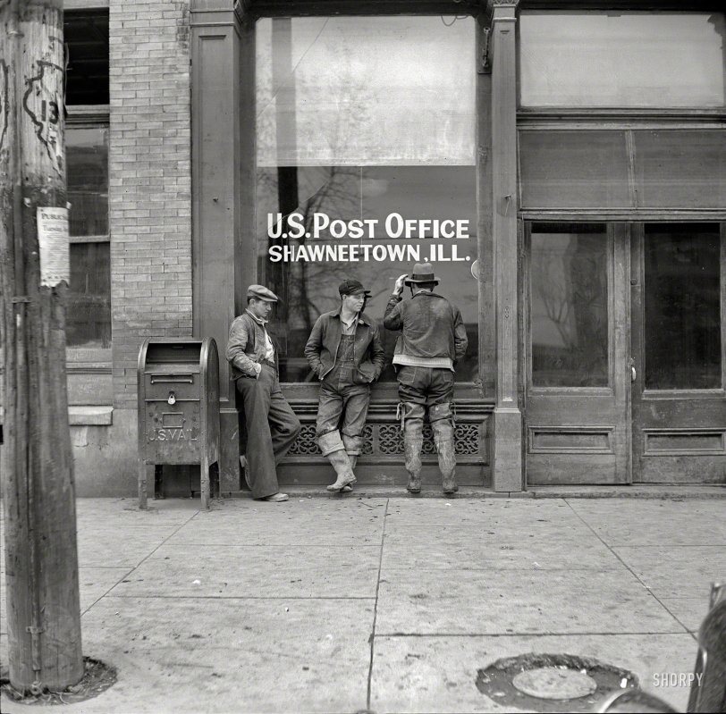
April 1937. "U.S. post office. Shawneetown, Illinois." Medium format negative by Russell Lee for the Resettlement Administration. View full size.
Exact match
Wow, JohnB wins the cigar! Even the seams in the concrete paving, and the circular utilities access match the photo.
High water mark?
Thank you, Shorpyites, for the history and significance of Shawnee. Without that, I might not have noticed this. But is that a high water mark about a foot or two up from the bottom of the post and the door next to it? Or would the flood of 1937 have left a much higher mark?
Hip waders
The Ohio River flooded in 1937 and the entire town was resettled to higher ground. An elderly neighbor entertained me as a boy with the stories of his helping move and rebuild the new Shawneetown.
1937 Flood Cleanup...
Shawneetown was wiped out by the Ohio River flood in January of 1937. Judging by the boots two of these fellows are wearing they could be part of a crew cleaning up some of the debris from the flood.
Old Shawneetown was located on the shores of the Ohio River and the devastation was so bad that the whole town was moved three miles inland.
This image shows what is now Old Shawneetown since it is only two months after the flood.
Google maps shows an interesting boundary line for the city probably as a result of the tent city that was set up for the refugees and the subsequent move of the whole town.
Here are a few more Russell Lee images from the same time period...
https://www.shorpy.com/node/14174
https://www.shorpy.com/node/14082
History of Shawneetown
Shawneetown was inundated when the Ohio River flooded at the beginning of 1937. Most of the town was moved to a safer location a few miles further from the river. The former riverside townsite is now called Old Shawneetown, and has only a couple hundred residents. This picture was taken a few months after the floods, apparently in a part of town that wasn't too heavily damaged.
If you look at Shawneetown in Google Maps' satellite view it's obvious that it is a planned community, and ironically enough there's some flooding visible in Old Shawneetown.
Notice the boots?
These guys may be part of this effort:
Old Shawneetown is a village in Gallatin County, Illinois, United States. As of the 2000 census, the village had a total population of 278. Located along the Ohio River, Shawneetown served as an important United States government administrative center for the Northwest Territory. The village was devastated by the Ohio River flood of 1937. The village's population was moved several miles inland to New Shawneetown. (from Wikipedia)
The Highway Sign
I've never seen highway signs painted on utility poles before. I suppose it would have been a cheap and simple approach in the Depression.
A few months after the Great Flood
And many years after any organized Shawnee presence had departed.
But the more important point: How could the USPS function without eight-digit Zip codes and two-letter state abbreviations?
With those boots
What are our subjects? Perhaps commercial fishermen, or farmers out in the muddy fields in spring planting, or, less likely, car wash workers just protecting precious shoes?
Anyone care to hazard an educated guess?







On Shorpy:
Today’s Top 5