


Framed or unframed, desk size to sofa size, printed by us in Arizona and Alabama since 2007. Explore now.
Shorpy is funded by you. Patreon contributors get an ad-free experience.
Learn more.

- Baldwin 62303
- Baldwin VO-1000
- Cold
- No expense spared
- Tough Guys
- Lost in Toyland
- And without gloves
- If I were a blindfolded time traveler
- Smoke Consumer Also Cooks
- Oh that stove!
- Possibly still there?
- What?!?
- $100 Reward
- Freeze Frame
- Texas Flyer wanted
- Just a Year Too Soon
- WWII -- Replacing men with women at the railroad crossing.
- Yes, Icing
- You kids drive me nuts!
- NOT An Easy Job
- I wonder
- Just add window boxes
- Icing Platform?
- Indiana Harbor Belt abides
- Freezing haze
- Corrections (for those who care)
- C&NW at Nelson
- Fallen Flags
- A dangerous job made worse
- Water Stop
Print Emporium
Bonus Army Bivouac: 1932
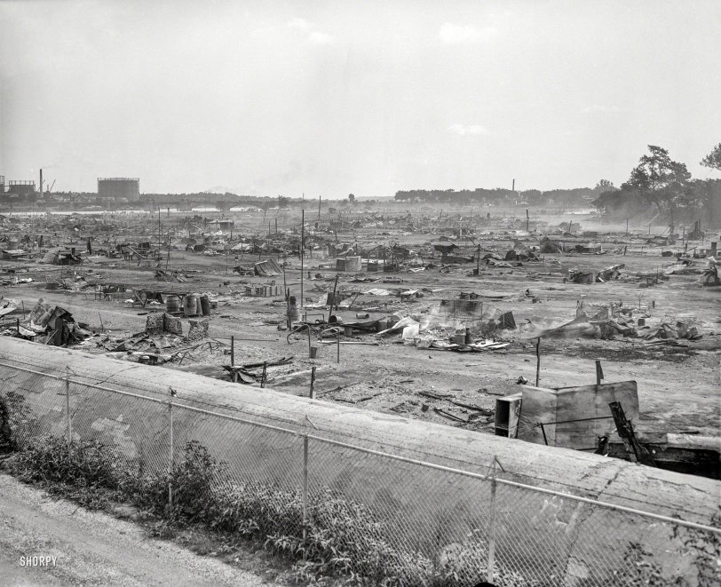
Washington, D.C., 1932. "Vacated 'Bonus Army' camp." Burned-out remnants of the Bonus marchers' camp in Anacostia Flats, with gas holders and what looks like a railroad bridge in the distance. And in the foreground, what we suppose might be conduit for the D.C. aqueduct. Harris & Ewing glass negative. View full size.
Poplar Point
That is the Poplar Point section of Anacostia Park looking east from the former greenhouses of the Architect of the Capitol toward the 11 Street SE bridge across what is now occupied by NACE HQ and AOC Park Police. The structure in the foreground is the Stickfoot Branch storm sewer relocated here in the teens when the "Anacostia Flats" were reclaimed.
Earthen Flood Contol Berm
The feature in the foreground is not a conduit but an earthen flood control berm. I found that in a pdf hard to link to called the Poplar Point RI Scoping Document, p. 2-5. The berm ties into a modern east-west flood wall along Anacostia Drive.
Makes sense that they'd want to defend against floods. All this land was fill using river channel dredgings.
Anacostia Bridge
The bridge was the Anacostia Bridge. Also known as the 11th Street Bridge. The streetlamps on the bridge are the clue it's a highway bridge and not a railroad bridge. The Bonus Army marched across that bridge everyday to rally on Capitol Hill and lobby Congress for their bonus.
This earlier photo on Shorpy also shows the ground surface conduit, but from a different angle.
Landscape features
The gasometers are likely those located in square 1025, just east of 12th St. SE, on the west bank of the Anacostia. (1921 Baist atlas extract below.)
As for that conduit in the foreground, it seems unlikely to be an aqueduct. My not-terribly-educated guess is that it's a sewer line running out to Poplar Point.
EDIT: The 1921 Baist atlas shows a labeled sewer line running southwest near the river & then bending west into the Anacostia Flats. Normally these atlases didn't label sewer lines -- instead, simply depicting them using black lines -- so there must have been something about this particular sewer line that made it different/worth noting. I'm guessing that in this case it was the line's above-ground siting.
We're the second largest city, man!
Yasgur's farm looked so much better before all those kids settled upon it. This devastation was left by the generation who brought the generation who complained about the waste left at Woodstock. The music may not have been as loud but I can hear humanity's wailing, moaning, and angst driven keening blaring in this image. Lets just hope the kids had something to eat and stayed off the brown acid.










On Shorpy:
Today’s Top 5