


Framed or unframed, desk size to sofa size, printed by us in Arizona and Alabama since 2007. Explore now.
Shorpy is funded by you. Patreon contributors get an ad-free experience.
Learn more.

- Freeze Frame
- Texas Flyer wanted
- Just a Year Too Soon
- WWII -- Replacing men with women at the railroad crossing.
- Yes, Icing
- You kids drive me nuts!
- NOT An Easy Job
- I wonder
- Just add window boxes
- Icing Platform?
- Indiana Harbor Belt abides
- Freezing haze
- Corrections (for those who care)
- C&NW at Nelson
- Fallen Flags
- A dangerous job made worse
- Water Stop
- Passenger trains have right of way over freights?
- Coal
- Never ceases to amaze me.
- Still chuggin' (in model form)
- Great shot
- Westerly Breeze
- For the men, a trapeze
- Tickled
- Sense of loneliness ...
- 2 cents
- Charm City
- What an Outrage
- Brighton Park
Print Emporium
No End in Sight: 1939
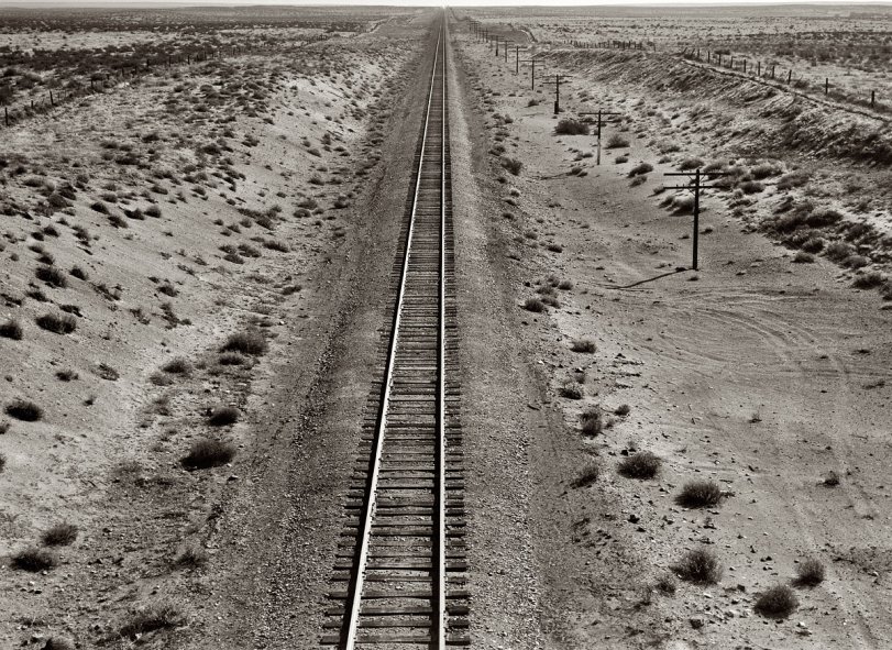
October 1939. Western Pacific tracks through the unclaimed desert of northern Oregon, 10 miles from the railroad station at Irrigon. View full size. 4x5 nitrate negative by Dorothea Lange for the Farm Security Administration.
Irrigon
Not that far from where I live, and it doesn't look that much different today.
[I drove across Oregon to Idaho in 2000. The high-desert part was gorgeous. - Dave]
Railroad at Irrigon
Irrigon is near Hinkle, almost on the banks of the Columbia River. Western Pacific never got to Oregon except by trackage rights on the Great Northern "Northern California Extension" from Klamath Falls, finished just in time (1931) for the depths of the Depression, but now possibly with its heaviest use ever. The track shown is now and has been for at least a century Union Pacific. Oops, wait a second -- depending on the actual location, that particular piece may have been lifted on account of river work, as Terraserver indicates a dead end at Irrigon. Perhaps it was originally Oregon Railway and Navigation, but the dog ate my homework.
From a bridge?
The pic was taken from some height over the tracks. I wonder if it was taken from a bridge.
Irrigon, Oregon
Can't be certain of the status of the rail line. It would be a Union Pacific line now and from Google Earth I do know that there is a rail line running east to west through the town of Irrigon, Oregon (what a great name), but I can't verify that this is it. In looking at the Google Earth images of this place I noticed these circular areas of presumably irrigated land along the rail line (Irrigon, Oregon, irrigation!) so it would seem that this area is being "reclaimed." I do know as someone who grew up and still lives in Saskatchewan the concept looks entirely foreign. Talk about crop circles!










On Shorpy:
Today’s Top 5