


Framed or unframed, desk size to sofa size, printed by us in Arizona and Alabama since 2007. Explore now.
Shorpy is funded by you. Patreon contributors get an ad-free experience.
Learn more.

- Lost in Toyland
- And without gloves
- If I were a blindfolded time traveler
- Smoke Consumer Also Cooks
- Oh that stove!
- Possibly still there?
- What?!?
- $100 Reward
- Freeze Frame
- Texas Flyer wanted
- Just a Year Too Soon
- WWII -- Replacing men with women at the railroad crossing.
- Yes, Icing
- You kids drive me nuts!
- NOT An Easy Job
- I wonder
- Just add window boxes
- Icing Platform?
- Indiana Harbor Belt abides
- Freezing haze
- Corrections (for those who care)
- C&NW at Nelson
- Fallen Flags
- A dangerous job made worse
- Water Stop
- Passenger trains have right of way over freights?
- Coal
- Never ceases to amaze me.
- Still chuggin' (in model form)
- Great shot
Print Emporium
Ashcans on Van Horn: 1935
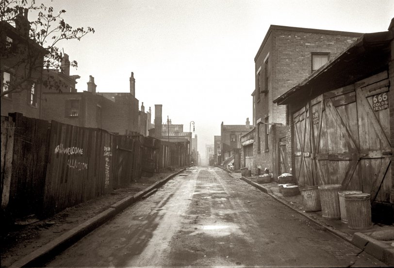
December 1935. Hamilton County, Ohio. Vicinity of Cincinnati. Dwellings on Van Horn Street. View full size. 35mm nitrate negative by Carl Mydans.
Price Hill
Can you tell me anything about who the Considine was whose name is found in Price Hill streets, Considine Ave, Considine Lane etc? Can you say whether the lower part down by the river and east toward the railroad slot was Irish in the 1870s-1880s? email: ryan90274@yahoo.com (that stomach is scary)
Van Horne Alley
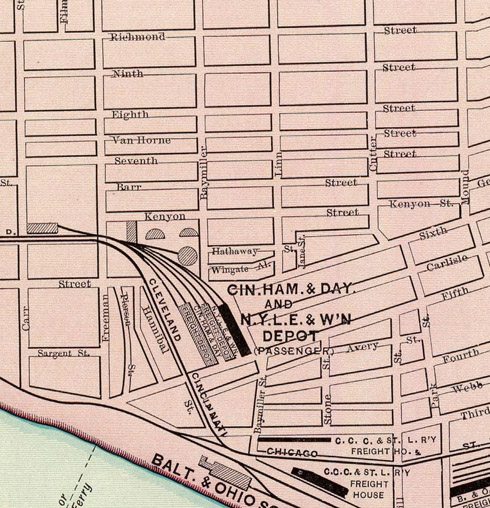
Van Horne Street was in what is now Queensgate. It ran east to west between Seventh and Eighth streets and between Carr and Mound. That area is now completely industrial and there seems to be no trace left of Van Horne Street's existence. I think it was right behind the buildings put up in the 1960's on the south side of what is now West Eighth. In the Hamilton County Auditor's website, a lot of these properties make reference "Vanhorne Alley."
666 For Colds & Fevers
I collect antique bottles, tins and other items and I just so happen to have an actual labeled, corked and sealed bottle of this medicine with the original contents. Yes, it is a strange name for a medicine, but many patent medicines back then had even stranger names as well as ingredients. 666 was made in Minneapolis, MN according to the (bright red and black, no less) label on my bottle. It supposedly cured colds, fevers, ague, catarrh, rheumatism and almost any other malady one could think of. Man, I would absolutely love to have one of those advertising signs for my collection! Another excellent photograph.
~ Boone H
Van Horn
If you draw an line from Carr at Dalton Street to Baymiller at Poplar, you might have an idea of the eastern boundary of the Ward/Precinct. Ninth Street was broken up to make room for the highway long ago - you can see a remnant of it if you search for Ninth Street West (9th St W) in 45203 on the map. That would be the southern boundary of the area. I assume Van Horn made up the northern part and the RR tracks the western. What we're looking at here is an area that time forgot - west of downtown/Over the Rhine and east of Price Hill. I don't know what they call that neighborhood now but I think the freeway killed it - not much there right now but a few factories/industries.
Van Horn Street
Thanks for the insights, links and pix.
Van Horn is Dutch, and there are some other Dutch named streets/alleys in that vicinity (east of Mill Creek).
The 1900 census shows Van Horn being part of the Ward 20, Precinct C boundary with Ninth, Baymiller and Carr...and part of the Ward 20, Precinct D boundary with Baymiller, Barr, RR, and Carr.
I know Ninth and Baymiller still exist...but haven't seen those others (except the railroad).
Price Hill
I made the comment on Price Hill. Sure, parts of Price Hill are fine, just like any town. But having worked there (near Considine, across from the police station), I can say with assurance that my viewpoint does not come from the media.
I have to concur with previous poster - this area is quite near the large train yard - on the edge of Price Hill, and was probably swallowed up sometime in the midcentury.
Price Hill
AT was a bit harsh on Price Hill. It's really not a poor gang infested slum that AT described. For some reason that's how too many people think of Price Hill. I'm not sure if it's learned from the media or something someone puts together in their own mind.
I'm not aware of a Van Horn St, but from the looks of the photo it could be taken from somewhere in East Price Hill. That's the part of Price Hill closest to downtown Cincinnati. If I had to guess, I would place it around Maryland Ave or near the bottom of Glenway Ave. Considering the street is so narrow and it looks like the the houses are not at street level on the left side, there are only a few places this could be. Maybe I'm not looking at the picture right?
There was a time in Cincinnati when a lot of street names were changed from their German names to more Anglo-Saxon sounding names. Not that Van Horn sounds German, but it's possible the street name no longer exists.
http://pricehillblog.com
Here's a good page of pictures of the historic Price Hill Incline.
And here are some photos I took recently from the other direction (looking down from the top of the hill, where the incline once stood).
Price Hill
I can share a bit of insight on Price Hill. Once upon a time was a nicer area, but now it's very rough - poor, violent and rundown. It's on the lower west side of the city, close to the river - a lot of cheap historic housing to be had, if you can stomach the crime and the overall depressed feel to the town.
One of the famed "Seven Hills" in Cincinnati. Inclines were a big thing back in the day.
Van Horn Street
Yes, sadly, I think so, Dave. This 1838 Bird's Eye Map of Cincinnati shows a Horne Street...but it likely predates Van Horn St, although it's in the general vicinity of Ward 20 (the 1900 census shows Van Horn in Precinct C and D of Ward 20). [Unfortunately, while nicely drawn, the 1900 Bird's Eye Map doesn't seem to include any names for streets, businesses, or points of interest.] The current Google satellite map indicates that there's an expressway about there...and major train tracks.
It also seems that it was possibly in the amazing-looking Price Hill area. Can some locals share insights into Price Hill?

Van Horn?
I live in Cincinnati and know the town well - however, I've never heard of Van Horn, nor can I find it online. It looks similar to some alleys I've been in, but I can't seem to place any landmarks. Any idea on how I could find it?
[It's probably long gone. A lot of these old neighborhoods and streets disappeared in the slum clearance projects of the 1950s and 60s. You look where they used to be and find expressways and overpasses. - Dave]
666
"666" is a medicine for colds and fever? Or a curse?
That's a very vivid picture, though. You can just imagine walking straight ahead, on down the hill.
[Cold medicine. - Dave]
Judging by the graffiti
At least the gangs seem friendly...











On Shorpy:
Today’s Top 5