


Framed or unframed, desk size to sofa size, printed by us in Arizona and Alabama since 2007. Explore now.
Shorpy is funded by you. Patreon contributors get an ad-free experience.
Learn more.


- Freeze Frame
- Texas Flyer wanted
- Just a Year Too Soon
- WWII -- Replacing men with women at the railroad crossing.
- Yes, Icing
- You kids drive me nuts!
- NOT An Easy Job
- I wonder
- Just add window boxes
- Icing Platform?
- Indiana Harbor Belt abides
- Freezing haze
- Corrections (for those who care)
- C&NW at Nelson
- Fallen Flags
- A dangerous job made worse
- Water Stop
- Passenger trains have right of way over freights?
- Coal
- Never ceases to amaze me.
- Still chuggin' (in model form)
- Great shot
- Westerly Breeze
- For the men, a trapeze
- Tickled
- Sense of loneliness ...
- 2 cents
- Charm City
- What an Outrage
- Brighton Park

Photos submitted by Shorpy members!
Print Emporium


Harpers Ferry: 1865

1865. "Harpers Ferry, West Virginia. View of Maryland Heights at confluence of Shenandoah and Potomac rivers." Wet plate glass negative (detail) by James Gardner. Civil War glass negative collection, Library of Congress. View full size.
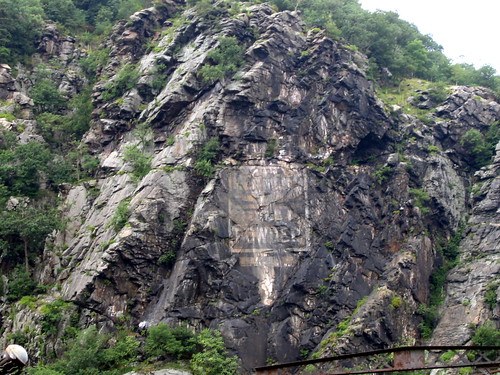
Powder Sign
According to the FAQ page on the NPS website for Harpers Ferry, the sign reads (or read) Mennen's Borated Talcum Toilet Powder, and it was painted some time between 1903 and 1906.
Last Trip Together
My husband Steve and his brother-in-law Jack visited Harpers Ferry in March of 1995. Steve, the shutterbug of the family, took along his camcorder and we have lots of footage. I've never been there and now, thanks to this photo, I'm going to "revisit" the area by viewing this footage again.
Steve and Jack will never know how poignant their vacation was. Jack passed away the very next month and Steve less than four years later. Both died in their 40's--both lives cut way too short.
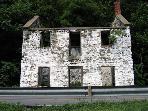
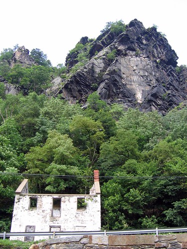
That House!!
Having visited Harper's Ferry several times, I started to search my photos to see if I had a modern comparable shot... but the thing that stood out most to me was that tiny white house on the left edge of the photo!! The structure is still there and people always stop to explore it!
There's also an old ad that seems to be painted into the side of the mountain, which I've never been able to figure out what it says... I see "powder"...
Harpers Ferry by Train
It's the Amtrak Capital Limited, train No. 29 west, and 30 east. Of course before Amtrak this town was served by the Baltimore and Ohio Railroad, and the original Capital Limited.
One of my favorite places on Earth!
I can remember stopping there on my way back to live in Kansas after graduating from high school and college in Maryland. I foolishly stood in the middle of the street and stared across the river at the tunnel. A horn honked and I turned and saw a beautiful long-haired blonde driving a huge red convertible. The world seemed rife with possiblities at that moment in a way that was different from anything that followed in later years!
Harpers Ferry Today
The C&O Canal Towpath, a national park, follows the Potomac River from Cumberland, Maryland, to Georgetown (D.C.). That makes it a 185-mile park, and the stretch through Harpers Ferry is among the most beautiful parts. Strongly recommended for anyone who can walk, bicycle or roll for a mile or two.
[There's also a nice footpath through the woods to Maryland Heights -- the top of the cliff to the left. The view is spectacular. - Dave]
Harpers Ferry
And Amtrak can take you right there on the spot. There's the train station on the west side of the rivers, which provides a great view as well. Amtrak train the Cardinal from NY to Chicago through Washington DC will take you there. It's a beautiful trip through the Adirondack mountains going west, been through there myself more than once.
Harpers Bridge Recent Views
Anyone interested in "current" views? 1974 from very roughly same location:

and 12/6/07 opposite direction,
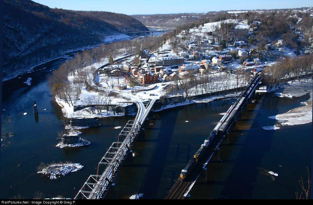
Bollman bridge piers remain in river at left, 1893 replacement bridge in center, 1930's replacement bridge at right as the railroad addressed the horrid original alignment here (look at those curves at span ends in the 1865 version).
The predecessors to the Bollman were blown up over and over again as the Civil War surged back and forth here.
Harpers Ferry Bridge
The bridge spans are some of the earliest examples of the Bollman truss, a hybrid truss/suspension design which originated on the B&O. The only surviving example is in Savage, Maryland.
Harpers Ferry
They've done a lot of restoration in the town over the past few years. It's always breezy because of the two rivers, so even on the hottest days it's usually pleasant. Plenty to see and learn, and the restaurants provide rest and excellent provender! Beautiful spot that we revisit often.
Anniversary of the Raid
Next year marks the 150th anniversary of the raid on Harpers Ferry. More info, including some very nice photos, here: http://www.harpersferryhistory.org/johnbrown/index.htm
Maryland Heights
This view looks downstream; the rocks on the far side are Maryland Heights. The bridge in the center is still represented by a line of piers adjacent to the present bridges.
Harpers Ferry
First saw a picture of Harpers Ferry in a 1950s National Geographic. Took the family to see it in 1958 and we climbed to the top of mountain where early pictures showed Union Troops. Now the National Park Service runs everything.
Bridge and Boat
That bridge is lovely! And it looks like there's a boat being drawn by horses in the canal on the left.
On Shorpy:
Today’s Top 5