

Framed or unframed, desk size to sofa size, printed by us in Arizona and Alabama since 2007. Explore now.
Shorpy is funded by you. Patreon contributors get an ad-free experience.
Learn more.

- Tough Guys
- Lost in Toyland
- And without gloves
- If I were a blindfolded time traveler
- Smoke Consumer Also Cooks
- Oh that stove!
- Possibly still there?
- What?!?
- $100 Reward
- Freeze Frame
- Texas Flyer wanted
- Just a Year Too Soon
- WWII -- Replacing men with women at the railroad crossing.
- Yes, Icing
- You kids drive me nuts!
- NOT An Easy Job
- I wonder
- Just add window boxes
- Icing Platform?
- Indiana Harbor Belt abides
- Freezing haze
- Corrections (for those who care)
- C&NW at Nelson
- Fallen Flags
- A dangerous job made worse
- Water Stop
- Passenger trains have right of way over freights?
- Coal
- Never ceases to amaze me.
- Still chuggin' (in model form)
Print Emporium
Ghosts of Atlanta: 1864
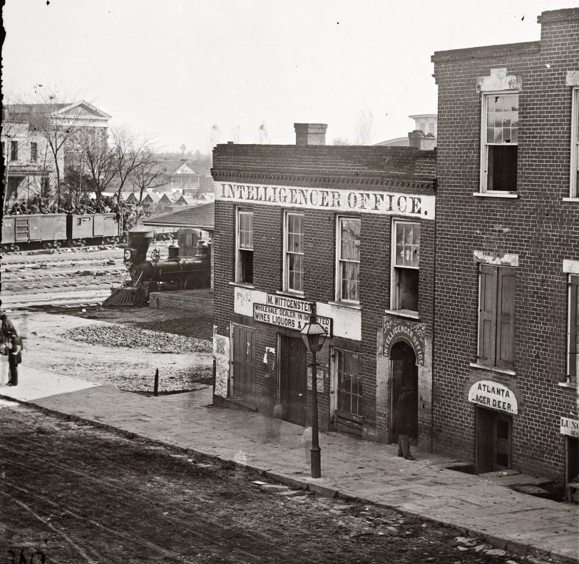
"The War in the West." 1864 photo (half of a stereograph) by George N. Barnard. Atlanta Intelligencer newspaper office by the railroad depot. Exposure times were so long that anyone walking appears only as an ectoplasmic blur. View full size. Note tents in background and troop train with soldiers atop the boxcars.
Location of this building
This building was located close to where the Peach Drop tower currently is, at Underground Atlanta. Because of the viaduct that created Underground Atlanta, it would have stood below the current street level. It was on Whitehall Street (now Peachtree).
Atlanta Intelligencer office
I have mapped many of Barnard's photographs on this interactive map. This picture is marked as Pushpin 10.
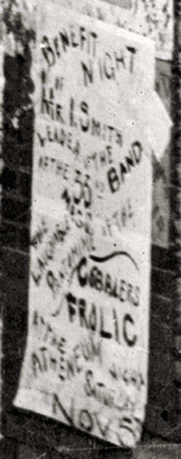
The playbill pasted to the building in the foreground advertises a stage show by Union troops to raise money for Mrs. Rebecca S. Welch, whose husband and son (Confederates) were both killed in Virginia.
The Bottom of the Playbill Reads:
Benefit Night / Maj(?) I. Smith / Leader of the Band / of the 33rd / Mass. / The Laughable Pantomime / The Cobbler’s Frolic / at the Atheneum / tonight / Saturday /Nov. 5th
Handbill
If you look on the corner of the building, you can just make out the word "frolic." Can't quite tell what comes before.
[Cobblers? Gobblers? - Dave]
Masonic Lodge
By the Masons' own records, the Lodge in the background stood on the corner of Lloyd (now Central Avenue) and Alabama Street, at south angle. So I would guess that if we're one block west it's on what is now Pryor Street or if two blocks Peachtree.
http://maps.google.com/maps?q=Alabama+Street+Atlanta&oe=&ie=UTF8&hl=en&h...
Atlanta Depot
Noticed that the same photographer walked a block or so to the right after taking this one. Does that help narrow the location down?
Whitehall & Alabama
My guess is the corner of Whitehall and Alabama Streets looking northeast. Currently Peachtree Street. Back then Peachtree changed to Whitehall south of Five Point.
Whitehall Street
WAR-TIME CAMP IN ATLANTA, GEORGIA, IN THE OLD CITY PARK
At the extreme left is the old Trout House, the principal hotel at the time; tracks of three of the chief railroads here crossed Whitehall Street, on which the "Intelligencer" office fronted.
http://docsouth.unc.edu/fpn/gordon/ill5.html
Underground Atlanta
My guess is that this was taken near the corner of Peachtree SW (then Whitehall) and Wall St. That would put it in what is now Underground Atlanta, I think.
Where was this in Atlanta? (answer)
I have been checking around and asking around about where this area in this photo might be, and a new friend on an Atlanta school site gave me this information...
Quote:
"Decatur Street is one of the main 5 roads that leads to Five Points, which basically is the center of downtown Atlanta, and was the center of town at that time. I think, but not sure, based on that picture and some of the other photos of the Union troop encampments, etc, that the Masonic Hall and Trout House were pretty close to what is now 5 Points. Most of that area of Decatur Street now has been renovated over the last 25 years and is where Georgia State University is located. I am fairly certain that neither of these structures is there any longer. When I went to GSU in the 1960's, I travelled almost the length of Decatur Street to get there. I do not recall ever seeing either of them, even back then, at that time, and to date, much of that area was torn down with Urban Renewal funds from the feds. It was mainly run down buildings and older businesses. It is possible that one of those run down buildings may have been one of the structures. However, Decatur Street runs east for a few miles, and they may have been futher east than I think. During the Civil War era, though, most of that area was rural. The actual Battle of Atlanta that is depicted in the Cyclorama painting took place away from the center of town out in the rural area of Decatur St/Road & what is now Dekalb Ave.(same road).
At least this clears up a little bit for us all.
sherri
Masonic Lodge (1864) in Atlanta
I have been researching, and it appears that the Masonic Lodge, and another building called The Trout House were on Decatur St. in Atlanta.
Click on this link http://memory.loc.gov/service/pnp/cwpb/03300/03304v.jpg (Trout house beside Masonic lodge.)
Here is a site with several images of Georgia during the Civil War...scroll down to 1864, and you will see the listing for this picture.
http://www.cviog.uga.edu/Projects/gainfo/cwphotos.htm
Now I am off to find out if this Masonic Lodge is still standing.
Try the main Peachtree
Try the main Peachtree Street / locate the address of the Atlanta terminal at the time / try Five Points area / could it be near Kennesaw? good luck--former Atlanta area resident and interested in knowing as well.
Masonic lodge
Perhaps the large masonic lodge in the background is still standing ... might be a clue.
where was this in Atlanta?
Anyone know where this was in Atlanta? Looking for an approximate street address.









On Shorpy:
Today’s Top 5