


Framed or unframed, desk size to sofa size, printed by us in Arizona and Alabama since 2007. Explore now.
Shorpy is funded by you. Patreon contributors get an ad-free experience.
Learn more.

- Lost in Toyland
- And without gloves
- If I were a blindfolded time traveler
- Smoke Consumer Also Cooks
- Oh that stove!
- Possibly still there?
- What?!?
- $100 Reward
- Freeze Frame
- Texas Flyer wanted
- Just a Year Too Soon
- WWII -- Replacing men with women at the railroad crossing.
- Yes, Icing
- You kids drive me nuts!
- NOT An Easy Job
- I wonder
- Just add window boxes
- Icing Platform?
- Indiana Harbor Belt abides
- Freezing haze
- Corrections (for those who care)
- C&NW at Nelson
- Fallen Flags
- A dangerous job made worse
- Water Stop
- Passenger trains have right of way over freights?
- Coal
- Never ceases to amaze me.
- Still chuggin' (in model form)
- Great shot
Print Emporium
Gasoline Plant: 1915
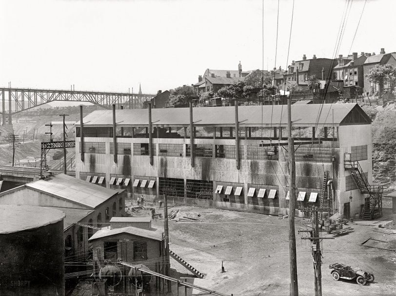
1915. "Dr. Walter F. Rittman. Gasoline plant at Pittsburg." Bureau of Mines chemical engineer Walter Rittman developed the "Rittman process" used in petroleum refining. Harris & Ewing Collection glass negative. View full size.
Skunk Hollow
The Anonymous Tipster before me is correct on all counts, regarding the location and landmarks in the picture. The site of the gas plant is now an intersection on the Martin Luther King Busway and North Neville Street. A careful inspection of the Bing bird's eye picture leads me to believe some of those houses on the hill are still there. The church peeking up from behind the Bloomfield Bridge is also still there, but no longer has its spire. I have no idea what the story is there.
It is indeed a natural feature. This hollow is the ancient (really ancient) channel cut by the Monongahela River. The Forks of the Ohio were about 1.25 miles west of the site (which is the direction the low B&O tracks are turning towards), and that's about 2.5 miles from the current Point. If you look at a map of Pittsburgh, you can easy see where the Mon makes one final turn west before forming the Ohio. At this point, the river once flowed north to this place. A topographic map makes this very easy to see, as the old channel hides in regular aerial photos. The PJRR/B&O/CSX/AVR tracks (hey I dont know how old your map is!) are the quickest way to trace it.
Incidentally, the University of Pittsburgh's historical photo archives has a picture of the Bloomfield Bridge facing the opposite direction down the hollow. The railroad overpass and accompanying signal bridge are visible, but this gasoline plant is obscured by another building. So who knows whether or not it survived until at least 1951, when that photo was taken.
Skunk Hollow
I believe this is in the "Skunk Hollow" section of Pittsburgh. That's the (old) Bloomfield Bridge. The tracks on the embankment to the left would be the Pennsylvania RR (Strip District ahead of us, Shadyside and East Liberty behind us). The tracks below, to the right, would be the B&O. Up on the hill to the right is Bloomfield.
The George Washington Bridge over Turtle Creek was a new structure; it didn't replace anything at that location.
Sole representative
The lone car in the right foreground is the only harbinger of the internal combustion revolution that will largely supplant all other modes of ground transport, and the reason for the gasoline refining technology.
George Westinghouse Bridge
Comparing with satellite, it appears the GW bridge was built right over the site of the gasoline plant, not where the high iron bridge was.
Turtle Creek Valley
Pretty sure it's the Turtle Creek Valley, East Pittsburgh. If so, the high bridge is on the current site of the George Westinghouse bridge, built 1932.
Bang!
I guess this plant was a rather dangerous place to work. There was another explosion there in 1918.
http://www.pittsburghlive.com/x/tribunereview/s_568139.html
http://www.rootsweb.ancestry.com/~pahsc/aetna.html
[There seem to have been several Aetna facilities around Pittsburgh. A munitions plant and a refinery (our photo) are not the same thing. - Dave]
Aetna Chemical Plant
I'm also curious as to where this is in Pittsburgh. The Aetna Chemical Company had a plant in Oakdale, 15 miles west of Pittsburgh but this appears more metropolitan than that. It is surprising how closely the residential neighborhood is located to this industrial setting. As the Anonymous Tipster pointed out, I expected to see water in the bottom of the large ravine (perhaps the mighty Monongahela!) - maybe the large confluence of rail tracks is a sufficient clue for a native Pittsburghian (Pittsburgher?) to figure out where this is.
Three Killed in Explosion
7 Others are Burned When
Superintendent Experiments With GasolinePiitsburgh, Pa., June 25. - Ten were burned, three fatally, late Friday by an explosion at the plant of the Aetna Chemical Company, where experiments are being made under government direction of a new process for the manufacture of gasoline. Among those who died was George Lobdell, superintendent of the plant.
Local representatives of the company maintained secrecy regarding the cause of the explosion, but according to the police, it resulted from an experiment being made by Supt. Lobdell.
Dr. Rittman, the government scientist whose processes are being experimented with, left the plant just before the explosion.
Washington Post, Jun 27, 1915
Chicken Coop
Between, and above the fourth and fifth smokestack from left, there appears to be a gravity defying chicken coop. Collect those eggs, and then scram!
Safety first
You think the catwalk between the buildings in the foreground is OSHA approved?
Geolocation
That enormous ravine looks rather wide and deep to be an excavated railroad cut, so I am assuming it is a natural geological feature, yet I don't see any stream that would have caused it. There has been excavating to lay the upper tier of tracks to the far left, perhaps on the same level as the tracks that run next to the factory (also a rock cut apparent in the far right). If the high bridge is also for rail traffic, this is quite a complex. Housing has made use of every foot of available real estate as far as the eye can see.










On Shorpy:
Today’s Top 5