

Framed or unframed, desk size to sofa size, printed by us in Arizona and Alabama since 2007. Explore now.
Shorpy is funded by you. Patreon contributors get an ad-free experience.
Learn more.

- Baldwin 62303
- Baldwin VO-1000
- Cold
- No expense spared
- Tough Guys
- Lost in Toyland
- And without gloves
- If I were a blindfolded time traveler
- Smoke Consumer Also Cooks
- Oh that stove!
- Possibly still there?
- What?!?
- $100 Reward
- Freeze Frame
- Texas Flyer wanted
- Just a Year Too Soon
- WWII -- Replacing men with women at the railroad crossing.
- Yes, Icing
- You kids drive me nuts!
- NOT An Easy Job
- I wonder
- Just add window boxes
- Icing Platform?
- Indiana Harbor Belt abides
- Freezing haze
- Corrections (for those who care)
- C&NW at Nelson
- Fallen Flags
- A dangerous job made worse
- Water Stop
Print Emporium
Lackawanna: 1900
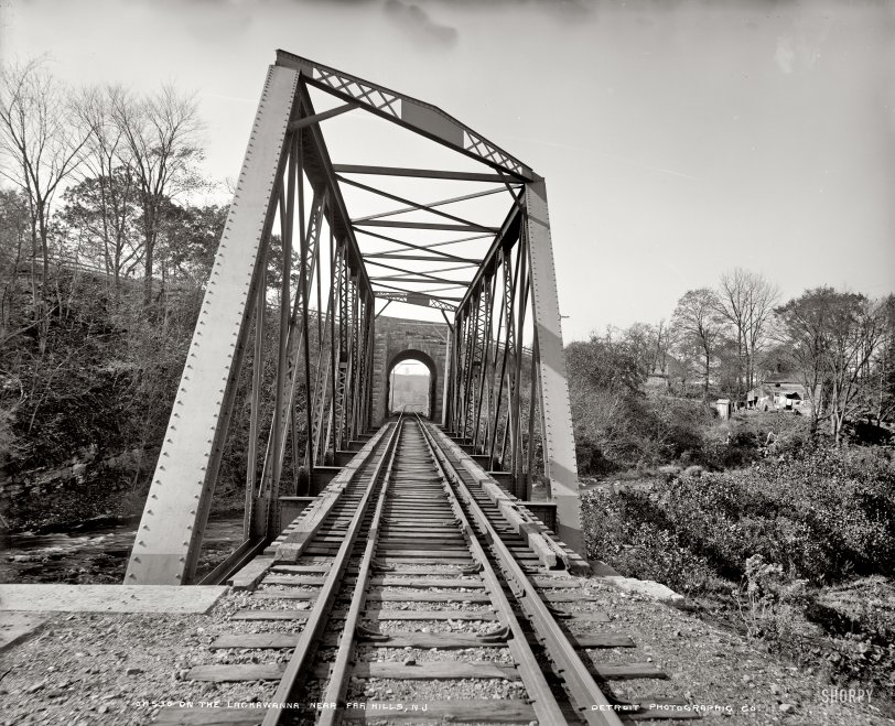
New Jersey circa 1900. "On the Lackawanna near Far Hills." With the bridge and little white house seen in the previous post. Detroit Publishing. View full size.
Hogback
The bridge angles seem strange because this is an example of a skewed truss. As another poster pointed out, a skew is a result of a bridge making a crossing at an angle other than 90°.
This bridge was known as the Hogback Bridge over the Raritan River and was replaced by NJ Transit in 2004 over the span of a single weekend. Its replacement is a non-skewed through truss. More info on the bridge and the replacement project can be found here.
No Calatrava
But it gets the job done, I suppose.
Telltales
Those are telltales hanging over the track to warn anyone riding top of car of upcoming low overhead. The bridge crosses the creek at an angle and therefore the abutments and trusses are staggered.
Oddly Angled
The trapezoidal footprint of the bridge probably reflects the engineers' desire for triangular, rather than square, bracing at the ends. Triangles being structurally much stronger than squares. We can also see a height gauge on either side of the tunnel, with hangers that would make a noise to indicate overheight locomotives. Wouldn't have much time to react, though.
There Goes My Vertigo!
I'm surprised no one has mentioned it previously, but do the angles of this bridge appear odd to anyone else? It's nearly enough to set off my vertigo. I'm sure the bridge was specifically engineered for this particular appication, but it almost gives the sense of just being slapped together.
Now this shot makes me wistful
I grew up on top of a hill about a mile or so to the right of the little white house in the first shot. We could look across the valley (which contained Main Street and the railroad tracks and the "stream", as we called it) at the Kate Macy Ladd Home (later Natirar, now some kind of resort).
The railroad trestle was exactly the same then, and we walked across it many times, always running as fast as we could through the tunnel. lest one of those old Erie-Lackawanna chuggers hit us. Peapack-Gladstone was the end stop on the spur, which had been built out that far to provide a NY connection for the residents of places like the Ladd house and Blairsden.
Years later, one of our large retrievers disappeared. We found him right at the spot in the photo, where he'd been hit by a train.
Like I said -- it makes me wistful. She was a very loving, if rather dumb, dog.
Double Tracks
Should a train derail here, the extra rails (guard rails) will keep the wheels trapped between the running rails and the guard rails and probably saving the bridge from being hit by the train or, worse yet, the train taking out the bridge.
Why we come.
I not only come here regularly for the cool old photos but the hilarious commentary and analysis are also worth the price of admission.
Twin Tracks
I should know this, since my grandfather was a railroad engineer on the IT, but why are there two sets of rails?
Absolutely fascinating.
I love finding the locations of the photos posted on Shorpy's using Google Earth. I could spend hours searching. I love this site.
180°
You're looking at this RR bridge from the other direction now. The road goes over the stone bridge at the other end, and the stucco house is over on the right, next to the road. And a stream or small river was only hinted at by the RR bridge as viewed in the previous Far Hills view.
To have a look abt. 2006 in Google Earth, here are the coordinates. 40.696909,-74.651628
Main Street changes to Peapack Road as it crosses over the RR tracks. The tracks then cross what's left of the river (Lackawanna?) which can barely be seen in Google maps as it meanders around in the wooded (green) areas. In Maps there is also a train headed up to the bridge from a mile south of the intersection. (Same coordinates, ya know)
But Dave already knew all this, right Dave?
[90°, not 180. The previous view was from the right, along the country lane that passes above the trestle seen here. The trestle is visible to the left in the previous photo. - Dave]
Given the camera angle from "Far Hills 1900" and the angle formed by the road and the RR tracks, the view in Lackawanna 1900 is, really Dave, 180° out. Pull out your protractor, please!
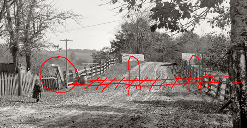
[To recap: This view is perpendicular, more or less, to the previous view. Below, the end of the trestle (circled) closest to the bridge, and the path of the tracks through the two stone arches whose headers bracket the road. - Dave]
Mystery Solved
Too cool that you found this photo!









On Shorpy:
Today’s Top 5