


Framed or unframed, desk size to sofa size, printed by us in Arizona and Alabama since 2007. Explore now.
Shorpy is funded by you. Patreon contributors get an ad-free experience.
Learn more.


- Texas Flyer wanted
- Just a Year Too Soon
- WWII -- Replacing men with women at the railroad crossing.
- Yes, Icing
- You kids drive me nuts!
- NOT An Easy Job
- I wonder
- Just add window boxes
- Icing Platform?
- Indiana Harbor Belt abides
- Freezing haze
- Corrections (for those who care)
- C&NW at Nelson
- Fallen Flags
- A dangerous job made worse
- Water Stop
- Passenger trains have right of way over freights?
- Coal
- Never ceases to amaze me.
- Still chuggin' (in model form)
- Great shot
- Westerly Breeze
- For the men, a trapeze
- Tickled
- Sense of loneliness ...
- 2 cents
- Charm City
- What an Outrage
- Brighton Park
- Catenary Supports

Photos submitted by Shorpy members!
Print Emporium


Picket Fences: 1903

Circa 1903. "A street in Yorktown, Virginia." 8x10 glass negative by none other than William Henry Jackson. Detroit Photographic Company. View full size.
+112
Below is the same view from April of 2015.

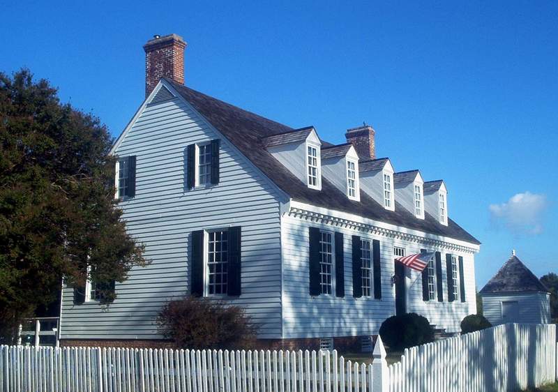
Sessions-Pope-Sheild House
The house adjacent to the Nelson House was built ca. 1692 on Lot 56 by local carpenter Thomas Sessions. It is of brick construction and not frame, as I erroneously noted below.
According to the York County Historic Resources Survey (2005 update; page 4):
"This one-and-a-half story brick dwelling is considered one of the finest examples of mid-eighteenth century colonial architecture. The building has remained intact for close to 300 years. During the Civil War, the building served as headquarters for Union General Henry M. Naglee following the abandonment of the town by the Confederates. The property has remained in the Sheild family since 1901, and has hosted Presidents Wilson, Harding, Hoover and Franklin D. Roosevelt."
If you look to your left
you will see the lovely Addams residence, to the right the is the beautiful home of the Munsters.
Digges Houses
The house in immediate foreground at right is the Dudley Digges House, built ca. 1760 (portico is a later addition, and has since been removed). It has a five-bay facade with interior end chimneys, and outbuildings that were reconstructed by the National Park Service in the 1970s.
The Cole Digges House (Dudley's father) is the white plaster house with the Bargain Store sign in the center background. It was built during the 1720s or later according to the historic structures report prepared by the architectural historians of Colonial Williamsburg. It is owned by the NPS and today houses a restaurant.
I am trying to find something about the house immediately in front of the Nelson House in this photo. It still survives today per Google Maps (along with the attached office), on the other side of Nelson Street at Main Street. Like the Dudley Digges House, it is five bays wide and of frame construction, but with a hipped roof and exterior brick chimneys.
Mud streets
As charming as this view is, it's hard to imagine what having dirt streets even on the main drag of town would have been like. Imagine just trying to walk down the road. And after a rain, the mixture of mud and horse manure must have been really ... quaint!
Google Street View Says
the three foreground homes are all still standing. The twin smokestacks at the left belong to the house at the NW corner of Main and Nelson. The house in front of it, obscured by the trees, is on the SW corner. The white foreground house on the right has five gables, three of which appear in the photo. It has lost its front porch. In this view the three chimneys on the left are in close alignment with the vintage photo.
Main Street between Smith and Read
The satellite view on Google Maps (alas there are no street views) shows that most of these structures are still standing. The impressive brick house on the left is the Nelson House, built ca. 1730 and home of Governor Thomas Nelson, signer of the Declaration of Independence. It faces Main St. and is located on the western corner of Main and Nelson Streets. A picture on Google Maps shows that there is a cannonball embedded between the windows in the pediment facing the camera in the photo above. The frame house with the hipped roof and the attached office on the left is across Nelson St. from the Nelson House.
The house in the immediate foreground at right is the ca. 1760 Dudley Digges House, which survives today sans portico at Main and Smith Streets.
The white house with 3 dormers and the "Bargain Store" sign is the Cole Digges House (father of Dudley), thought to be constructed ca. 1720ff. It is located at Main and Read Streets and now houses the Carrott Tree restaurant.
Main Street
This is Main Street at the intersection of Smith Street. The house on the right is the Cole Digges House and the Nelson House is down the street on the left. The Victory Monument is to the right and slightly behind the camera. A very nice place to visit today as it must have been 250 years ago.
Main Street in Yorktown
The house on the right has had the front porch removed and the shoddy looking addition to the beautiful brick house on the left is now gone as well. Both homes appear to have been beautifully preserved and most of the structures seen further down the street on the right no longer exist.
Signage
Can anyone read the sign hanging out from a building right down the middle of the road? Really surprised to see any signage in what I thought was a rural area.
[BARGAIN STORE J.R. Hillman & Co. General Merchandise - Dave]

What a challenge
I would be stunned if someone was able to pinpoint this location.
Twain Street
I'm looking to see Tom Sawyer painting the fence, or getting everyone else to paint it.
Ye Olde Main Street.
This is Main Street, Yorktown. The first building on the right after the picket fence is still there. Care has been taken to protect and preserve many of the old buildings in this area.
On Shorpy:
Today’s Top 5