


Framed or unframed, desk size to sofa size, printed by us in Arizona and Alabama since 2007. Explore now.
Shorpy is funded by you. Patreon contributors get an ad-free experience.
Learn more.


- Baldwin 62303
- Baldwin VO-1000
- Cold
- No expense spared
- Tough Guys
- Lost in Toyland
- And without gloves
- If I were a blindfolded time traveler
- Smoke Consumer Also Cooks
- Oh that stove!
- Possibly still there?
- What?!?
- $100 Reward
- Freeze Frame
- Texas Flyer wanted
- Just a Year Too Soon
- WWII -- Replacing men with women at the railroad crossing.
- Yes, Icing
- You kids drive me nuts!
- NOT An Easy Job
- I wonder
- Just add window boxes
- Icing Platform?
- Indiana Harbor Belt abides
- Freezing haze
- Corrections (for those who care)
- C&NW at Nelson
- Fallen Flags
- A dangerous job made worse
- Water Stop

Photos submitted by Shorpy members!
Print Emporium


C.U.: 1910

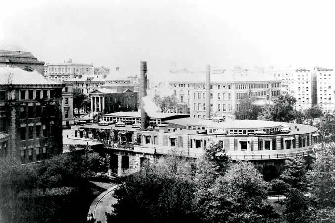
New York circa 1910. "The campus, Columbia University." 8x10 inch dry plate glass negative, Detroit Publishing Company. View full size.
Some corrections
I've been meaning to comment on this photo for over two years - finally got log-in credentials (thanks ken!)
In particular, I'd like to make same corrections to mgoldey's otherwise excellent comment.
This photo is actually taken at the base of University Hall, probably just west of the building, before the driveway passes into/under it. The shadow in the immediate foreground is of one of University Hall's steam chimneys (for the power plant located in its recesses). See e.g. here.
Judging by the fall of the shadow, it's in the morning with the sun in the east. The photographer is facing northwest. At the very left edge of the frame is just a little bit of the semi-circular rear of Havemeyer Hall (not University Hall). The famous lecture hall featured in so many movies (309 Havemeyer Hall) is located in this semi-circular portion of the building.
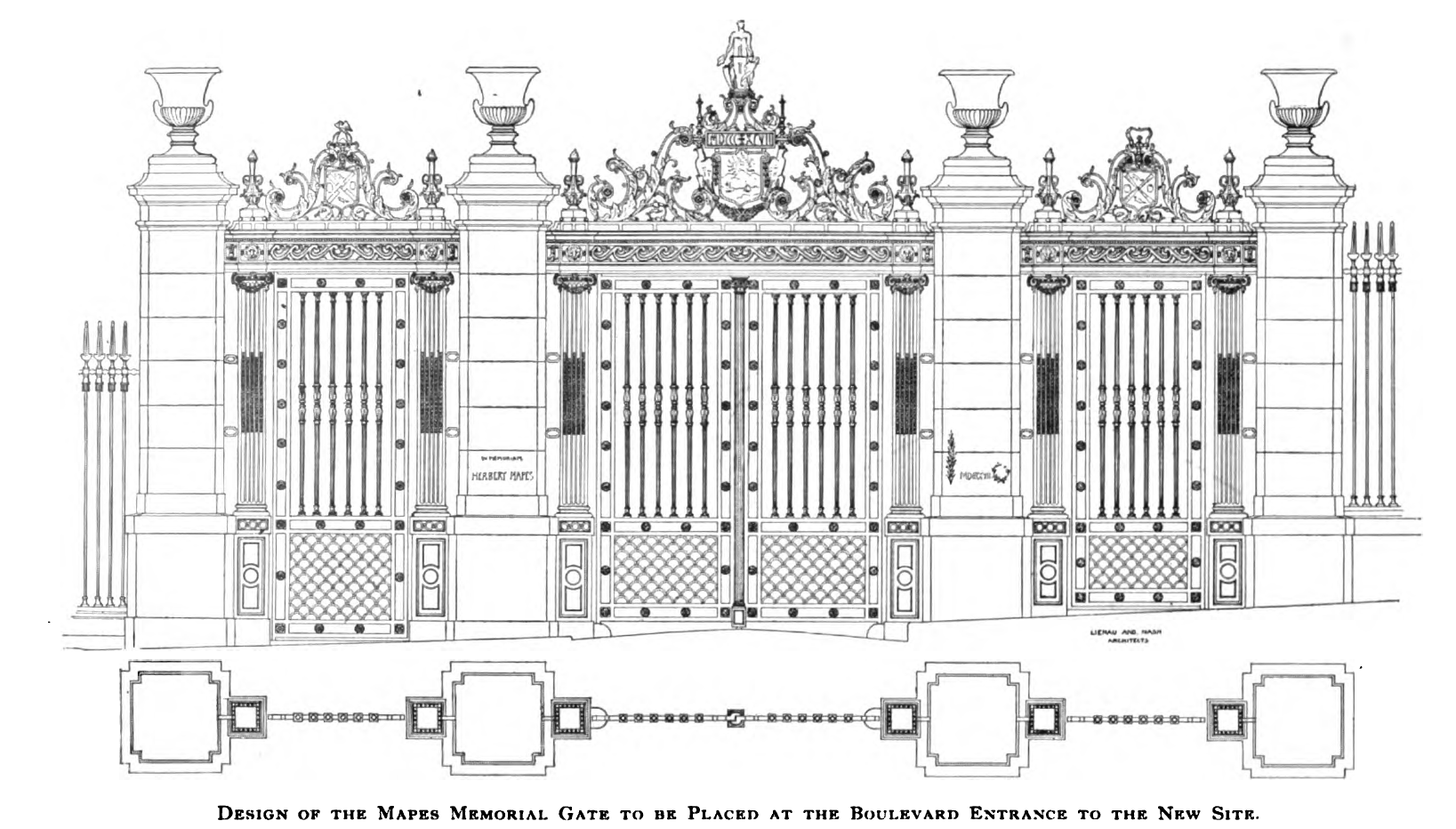
The elaborate gates at the end of the driveway are the Mapes Memorial Gate. They were torn down at some point that I've yet to determine. (See: this and this.)
Across Broadway from the Gate is, as correctly surmised by mgoldey, Milbank Hall of Barnard College. Milbank is actually three different joined buildings - visible in this photo are the east and west wings of the building, known as Brinkerhoff and Fiske Halls, respectively.
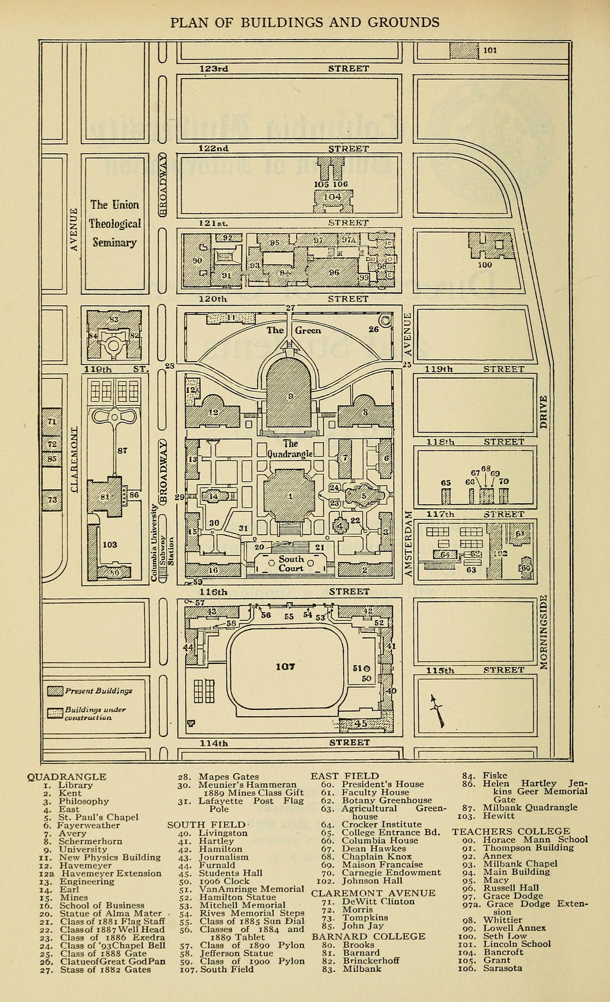
Where this photo was taken is now an "underground" service area of the campus. Chandler Labs stands immediately west of where the Gate is; Pupin Hall was built on the near side of 120th Street across from the Teachers College building visible on the right hand side of the frame. You can see both listed as under construction in this 1925 campus map.
Eventually Dodge Fitness Center would be constructed on the land north of the driveway, and Havemeyer Extension south of it. Eventually a platform and plaza would be constructed roughly four stories above what you see here, which would become a dark, dirty, service area.
The Grove
This area was called The Grove. It's mostly covered with buildings today, but there is still an open courtyard where they keep the dumpsters, called "The Grove."
How many man-hole covers do they need.
Was it normal to have a man-hole cover every 12 feet? There seems to be an awful lot on this short road.
The woman with the stroller isn't texting, that's a radio controlled stroller.
The North End of Campus
What an odd view! I believe that the picture was taken from a spot that is now beneath the surface of the campus, just north and a little east of University Hall.
The round building just peeking out on the left side is the back of the University Hall gym, the inside of which is shown here: https://www.shorpy.com/node/4893 In that picture, due left at the apex of the curve would be the north end of the building's curve that's visible in this image.
The open lawn to the north is now the the Shapiro Center and/or part of the Engineering School, and there is a huge plaza built up more or less level with the windows of the old gym, and a very long flight of stairs down to 120th Street. The gates, driveway, trees, etc., are long gone.
Across 120th Street is Teacher's College and, to the left, across Broadway, Union Theological Seminary.
The two boxy, red brick buildings, built in the McKim, Mead & White style of the rest of the campus, are a mystery to me. The farther one could be what lies beneath the skin of the Northwest Corner Science Building. The closer one sits in an open space in the plaza mentioned above, on top of the new, Dodge Gym. There is, today, a building parallel to 120th Street, called Pupin Hall, that is in the style of the original MM&W plan. The two chimneys visible over the roof of the closer building may be part of what is now Pupin Hall. The closer buildings may have been demolished. I just don't know.
Edit -- looking again, I think that the two red brick buildings are part of the Barnard campus, on the west side of Broadway.
Pay attention!
That lady by the gate might want to pay a bit more attention to her baby. There ought to be a law against texting while tending a stroller!
Things to come
Baby buggy in the sun, momma texting.
On Shorpy:
Today’s Top 5