


Framed or unframed, desk size to sofa size, printed by us in Arizona and Alabama since 2007. Explore now.
Shorpy is funded by you. Patreon contributors get an ad-free experience.
Learn more.

- Freeze Frame
- Texas Flyer wanted
- Just a Year Too Soon
- WWII -- Replacing men with women at the railroad crossing.
- Yes, Icing
- You kids drive me nuts!
- NOT An Easy Job
- I wonder
- Just add window boxes
- Icing Platform?
- Indiana Harbor Belt abides
- Freezing haze
- Corrections (for those who care)
- C&NW at Nelson
- Fallen Flags
- A dangerous job made worse
- Water Stop
- Passenger trains have right of way over freights?
- Coal
- Never ceases to amaze me.
- Still chuggin' (in model form)
- Great shot
- Westerly Breeze
- For the men, a trapeze
- Tickled
- Sense of loneliness ...
- 2 cents
- Charm City
- What an Outrage
- Brighton Park
Print Emporium
Chez Balberg: 1921
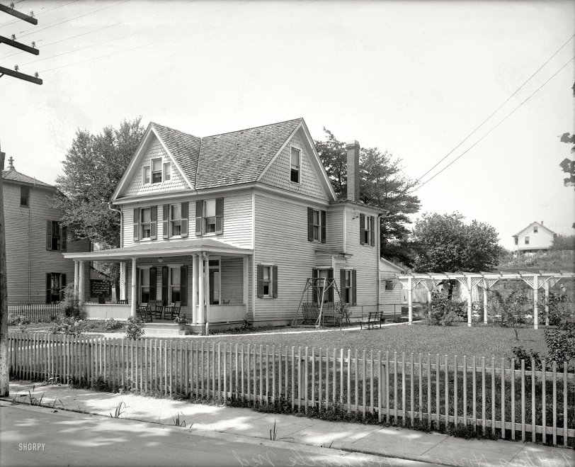
Prince George's County, Maryland, circa 1921. "Balberg house, Hyattsville." The address looks to be 137. Bonus points if you can find the street. View full size.
Teamwork!
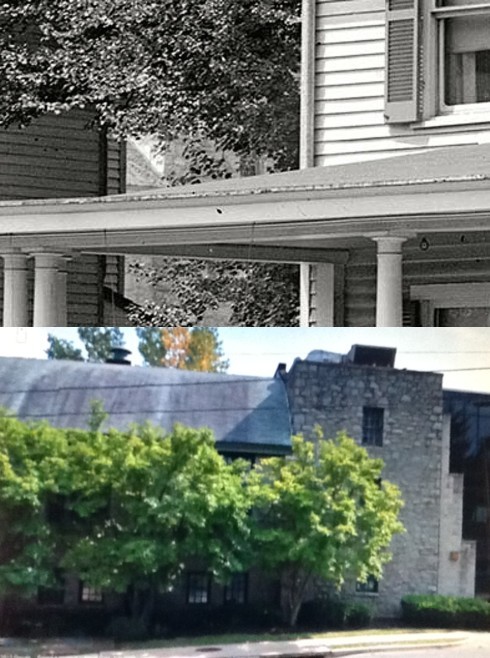
Thanks Groucho! The key was provided by Splunge when he noted that way back in 1921, Maryland Avenue was the only street with lot numbers as high as 137. A quick check of the 1922 Sanborn map showed houses on Lots 135 and 137 that resembled those in the photo. Drawing a line on the map along the photographer's line of sight passing between the two houses, it intersected the north wall of a large building across the street (Maryland National Guard Armory). The building is still there, although it's now owned by a church. A trip around the block on Google Street yielded the photo clearly showing the sloping roof, stone wall, and window!
Wow!
Jumbo, I think you're right but how in the world did you find it? I had to study your posted photos twice to see the similarities.
Found It!
The building visible between the two houses is the north wall of the Maryland National Guard Armory. That means the two houses occupied Lots 135 and 137 on Maryland Avenue (now Baltimore Avenue), and both were demolished in 1929 to make way for the new 'C & P Telephone Co.' building, which was built in 1930. It's now the Verizon building.
Riverdale Mayor
Excellent sleuthing by E Helliwell and jumbo501. Max Vollberg was councilman (ca 1925-30) and mayor (1930-32) of Riverdale, Md. - now Riverdale Park.
Detective Work
According to official Hyattsville records, in 1941 'Wingrest Avenue' was changed to the 4100 block of Decatur Street.
137 Wing Rest Avenue
This is the house of Max Vollberg, not Balberg. It is at 137 Wing Rest Avenue. The family is in the 1920 census of Hyattsville. Mr. Vollberg's 1922 US Passport application has pictures on the second page showing members of his family and one picture showing a part of the front porch beams of this house. All of this information can be found at ancestry.com.
Little bit of heaven
Oh, I can remember those old double swings. My grandmother had one of those!!!!
Bolberg?
I figured the easy path to locating this house would be the 1920 US Census. Appears there isn't even a Balberg living in Maryland (not the first time I've been wrong).
Also, having lived in the area I know that Hyattsville blends into adjacent communities, so the house could be as far north as College Park or south towards Bladensburg.
Maybe
I think I might have found the location. Based on the 1922 Sanborn Fire Insurance Map of Hyattsville, it appears that only one street had addresses going as high as 137 - that being Maryland Avenue, which is now Baltimore Avenue. What was once a far more residential area is now quite commercial, with only a few reminders of its not-so-distant past. The structures depicted on the 1922 map seem to align with the photograph that Dave posted. Here is where I believe the "Balberg House" once stood (note that the building that is visible on the Google map would have been obscured in the ca.1921 picture; the Sanford map suggests that it was standing at that time):
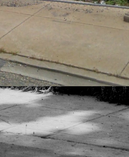
Further evidence: if you scoot Street View back a few feet (just to the south of Jefferson, say, about here), you'll note that the distinctive old "two-paned" sidewalk is still in place, barely protruding above street level:
Hello Hyattsville Historic District?
Street view may tell us, but my guess is either Farragut, Gallatin, or 42nd.
Trick question
I'm not sure if Dave knew it when he posted, but giving the house number from 1921 and asking for the street is a trick question. On 11 August 1941, Prince George's County (including Hyattsville) renamed and renumbered their streets to better match the scheme from neighboring Washington DC. Thus, today's Ingraham Street was Oak Street in 1921, Oglethorpe Street was Arundel Avenue; Locust, Park, Avon, and Adalyn Avenues were combined with Grove Street to create the modern-day 42nd Place, etc. The house numbers changed as well, so looking for a modern-day "137" will prove fruitless.
I am following a few leads to identify this house and its location (I need all the bonus points I can get). Question for Dave, in case my frustration level gets too high - do *you* know the street name and true location?
Yards are work spaces
This is seen nicely here. Laundry is hung in the back of the house and a very pretty pergola creates a formal decorative garden in the side yard, and it hides the vegetable garden which is located behind. Note the gardener wearing a straw hat.
Question
Please advise what a Shorpy addict can do with his or her "bonus points" which you occasionally offer, as in this photo?
Street name
It apperas that they painted the name of the street right on the pavement in the lower left corner of the picture, Shorpy Street. Nice houses way before they all got plastered w/Vinyl.
I found the street!
It's just past the fence and beyond the sidewalk.
You be the judge, Mr. Twain
Looks like Becky Thatcher's house and Tom Sawyer is about to come along with a stick to run along that wooden fence.








On Shorpy:
Today’s Top 5