


Framed or unframed, desk size to sofa size, printed by us in Arizona and Alabama since 2007. Explore now.
Shorpy is funded by you. Patreon contributors get an ad-free experience.
Learn more.


- Tough Guys
- Lost in Toyland
- And without gloves
- If I were a blindfolded time traveler
- Smoke Consumer Also Cooks
- Oh that stove!
- Possibly still there?
- What?!?
- $100 Reward
- Freeze Frame
- Texas Flyer wanted
- Just a Year Too Soon
- WWII -- Replacing men with women at the railroad crossing.
- Yes, Icing
- You kids drive me nuts!
- NOT An Easy Job
- I wonder
- Just add window boxes
- Icing Platform?
- Indiana Harbor Belt abides
- Freezing haze
- Corrections (for those who care)
- C&NW at Nelson
- Fallen Flags
- A dangerous job made worse
- Water Stop
- Passenger trains have right of way over freights?
- Coal
- Never ceases to amaze me.
- Still chuggin' (in model form)

Photos submitted by Shorpy members!
Print Emporium


Harlem River: 1890

The Washington Bridge and High Bridge over the Harlem River along the northern boundary of Manhattan, looking south. Circa 1890 albumen print from a photograph by William Henry Jackson. Detroit Publishing Co. View full size.
Historic slide show of the Harlem River
See a slideshow of historic images of the majestic Harlem River here.
Harlem River Speedway
Look through the Washington Bridge on the right side and see Highbridge water tower. It's still there, although the reservoir that was beneath it is now a park. The muddy shore on the right was later made into the Harlem Speedway for horse & buggy racing. Today the Speedway is a "Class A" bicycle path on the river side, and the Harlem River Drive inboard of that! The arches that stepped across the river (farthest bridge) were removed when they widened the Harlem River and created The Erie Ship Canal. Today the arch piers that touch the river are now one large arch like the Washington Bridge in the foreground of this photo. The NYC Parks Department "owns" Highbridge now and they are refitting it for a linear park and bike path. It should be open by 2009.
Beautiful
Nicely architected and nicely implemented! This gives the lie to my boyhood fantasy that nothing significant was accomplished before I was born.
High Bridge
It looks like an aqueduct because it was an aqueduct. The Croton Aqueduct carried water from Westchester county into Manhattan. Hidden by the Washington Bridge is the still-standing High Bridge tower. From the tower, water was gravity fed to the rest of Manhattan.
Graffiti on the rocks?
Beautiful picture! I never realized how beautiful the High Bridge had been -- it calls to mind a Roman aqueduct...
Hey, do you think the large rocks in the right foreground have graffiti on them? I thought first it was some natural geologic pattern, but it sure looks like an "A" on one of them. If so, I wonder what it says ...
Harlem River Bridges
The Washington bridge (at 181st Street) looks largely the same, but the Harlem High Bridge (at about 174th Street), once famously the prettiest bridge to Manhattan, has been significantly reworked. The entire middle section, over the water, has been replaced with a now-rusting metal structure. It is sadly ugly, but presumably provides easier passage for boats.
There is now a third bridge that sits between the two at about 178th Street.
Here is a view of the two northernmost bridges from the south:

That's the Harlem River Parkway on the left; it follows the route of the old Harlem Speedway, of which I am sure there are many photos in the archives, perhaps to be delivered to us by Shorpy in the future.
Here is an image of the High Bridge showing the replaced section in the middle:
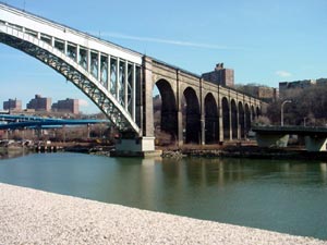
The High Bridge does not carry cars or trains; there is some kind of water pipe embedded under the roadway, and the surface has been closed since the 1960s. Supposedly, local kids used to walk out to the middle and drop rocks on tourist boats passing underneath. Personally, I do not believe this.
The city of New York has allocated money for repairing the surface of the bridge and it is scheduled to reopen as a pedestrian and bicycle route across the East River.
On Shorpy:
Today’s Top 5