

Framed or unframed, desk size to sofa size, printed by us in Arizona and Alabama since 2007. Explore now.
Shorpy is funded by you. Patreon contributors get an ad-free experience.
Learn more.

- Tough Guys
- Lost in Toyland
- And without gloves
- If I were a blindfolded time traveler
- Smoke Consumer Also Cooks
- Oh that stove!
- Possibly still there?
- What?!?
- $100 Reward
- Freeze Frame
- Texas Flyer wanted
- Just a Year Too Soon
- WWII -- Replacing men with women at the railroad crossing.
- Yes, Icing
- You kids drive me nuts!
- NOT An Easy Job
- I wonder
- Just add window boxes
- Icing Platform?
- Indiana Harbor Belt abides
- Freezing haze
- Corrections (for those who care)
- C&NW at Nelson
- Fallen Flags
- A dangerous job made worse
- Water Stop
- Passenger trains have right of way over freights?
- Coal
- Never ceases to amaze me.
- Still chuggin' (in model form)
Print Emporium
Wyoming: 1940
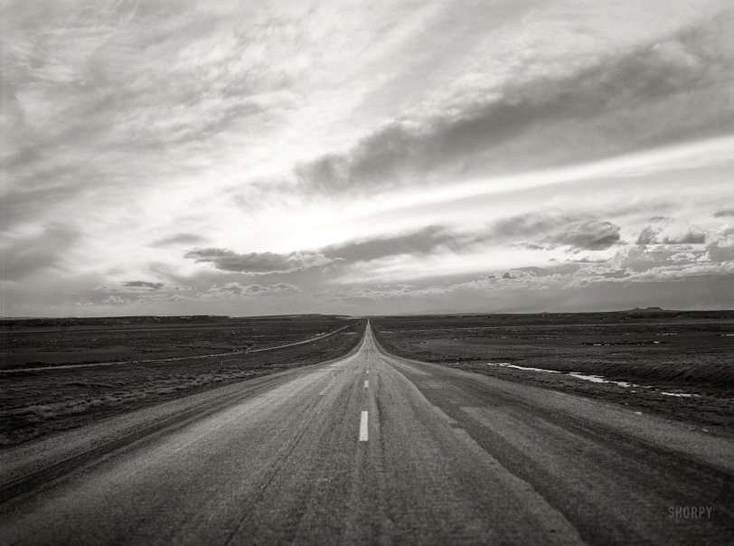
March 1940. "Highway U.S. 30. Sweetwater County, Wyoming." Photo by Arthur Rothstein for the Farm Security Administration. View full size.
Middle of Nowhere
Years ago, on a motorcycle ride in eastern Oregon on US 395 between Burns and John Day, I found a similar spot. Stopped, looked around to make sure of a lack of fences, telephone or power poles, or any human structure. I took a picture and sent it to family overseas with the statement "This is the middle of nowhere."
The above picture really does qualify, better than the one I took.
Route 30
I rode US 30 for the first half of a cross-country motorcycle trip about 15 years ago. Although much of it is now Interstate, a lot remains secondary and just a joy to ride on.
I-80 now
Only a small sliver of U.S. 30 in the far western part of the county now.
Just West of Wamsutter
Location is just west of Wamsutter, Wyoming. The rocky high point on the right is Eagle Nest Butte.
Vanishing Point
Here is a visual definition of "vanishing point" if ever I saw one...
On a clear day you can see forever
Certainly looks like the middle of nowhere. Great spot to hitchhike if you have the time.
Running On Empty
It almost looks like the background of the cover of Jackson Browne's album.










On Shorpy:
Today’s Top 5