

Framed or unframed, desk size to sofa size, printed by us in Arizona and Alabama since 2007. Explore now.
Shorpy is funded by you. Patreon contributors get an ad-free experience.
Learn more.

- Baldwin 62303
- Baldwin VO-1000
- Cold
- No expense spared
- Tough Guys
- Lost in Toyland
- And without gloves
- If I were a blindfolded time traveler
- Smoke Consumer Also Cooks
- Oh that stove!
- Possibly still there?
- What?!?
- $100 Reward
- Freeze Frame
- Texas Flyer wanted
- Just a Year Too Soon
- WWII -- Replacing men with women at the railroad crossing.
- Yes, Icing
- You kids drive me nuts!
- NOT An Easy Job
- I wonder
- Just add window boxes
- Icing Platform?
- Indiana Harbor Belt abides
- Freezing haze
- Corrections (for those who care)
- C&NW at Nelson
- Fallen Flags
- A dangerous job made worse
- Water Stop
Print Emporium
Under the El: 1940
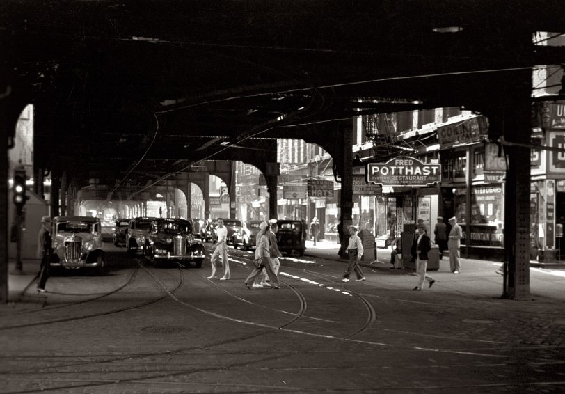
July 1940. Another view under the elevated tracks in Chicago. View full size. 35mm nitrate negative by John Vachon for the Farm Security Administration.
+77
Below is the same perspective from June of 2017 (minus the charm in the original).
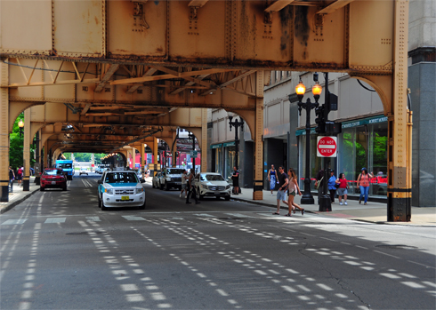
Looking west on West Van Buren from South State
The view is under the south perimeter of the Union Loop El, which straddles Van Buren Street from Wells Street to Wabash Avenue.
As has already been mentioned, there are two clues that show this view looks west on Van Buren at State. First is the Fred Potthast Restaurant. The low address number (4) indicates that we are looking west along the first block of West Van Buren, as State Street (in the foreground) is the dividing line for Chicago streets running east and west.
Second and even more telling is the track junction allowing the streetcars to operate eastbound on Van Buren and continue on State north or south.
Wells and Lake
I've studied this image and I really think that it was shot at Wells and Lake, the northern and western corner of the Loop. The image appears to be looking southward while standing on Wells.
Look at the buildings in this Google Map street view. Specifically, pan or slide to the right and notice the building with the "cut" or beveled corner. The doorway is where it should be, in the beveled corner. The other Loop corners don't have existing structures that come as close as this. Of course, the original structures in Vachon's image may no longer exist, and I could be wrong.
View Larger Mapcbp=12,178.12917418537864,,0,14.927384966794076
Anyway, it seems convincing. I'm going to check it out on foot soon if the temperature ever climbs above freezing. Perhaps this means I need a hobby.
The only thing left from 1940 ...
is the steel holding up the El and the location of a couple of manholes in the street. Streetview in maps.google is my friend when my memory is not.
The Streets
The photographer appears to be standing in the intersection of State Street (left to right) and Van Buren, looking Westward.
More recently this area was used in the remake of Ocean's Eleven, it's where Matt Damon pulls the business card out of his pocket that Danny Ocean swapped for the wallet Matt had just lifted from the unsuspected El rider.
Tables for Ladies
Not only the Table sign there was usually a Ladies Entrance which bypassed the bar and led directly to the table section.
I remember the local neighborhood taverns in Baltimore would have those signs and alternate entrances which no self respecting man would use no matter if it were pouring down rain and you had to walk an extra 20 to 50 feet for the Bar entrance.
State and Van Buren looking west
today there is a park on the right and the Washington Library on the left. The next street light is Plymouth Court
Fred Potthast
Oh Fred, thanks for having such a searchable name. Fred Potthast's restaurant was at 4 West Van Buren, per a 1933 Chicago Tribune article about Loop taverns reopening in the wake of Prohibition's repeal. "Below stairs Fred Potthast, the second generation of his name and occupation in that premises, has his license tucked away against the impending change, but won’t need to hire any carpenters to build him a brand new bar. He’s quite satisfied with the one that was installed there forty-four years ago [1889] by his father, famous for his sea food cuisine."
Even more significant: we are looking at the block on which Jake and Elwood blues lived in the SRO hotel in "The Blues Brothers"--the block ostensibly destroyed by a homicidal Carrie Fisher.
The space is now a vacant lot that was supposed to become a park when the library was built but never has. Lotta history dere though.
Under the El
It's Jewelers Row, all right, but I think you're shooting a bit too far to the north. The facade of the building does not match the second story of the Carson Pirie Scott building on that intersection. We should be thinking closer to Jackson Boulevard or Van Buren. I've seen the Schlitz marquees before.
The El intersection
It's one of the corners of the Loop ... my husband thinks the street going away from the viewer toward the vanishing point is Wabash, and the street crossing it is Lake. This is how it looks today. (Google Map Street View).
Tables for Ladies...
It's not every oysters/fish restaurant that can claim that.
["Table for Ladies" seems to have been a pretty common sign for restaurants. More so back toward the turn of the century. - Dave]







On Shorpy:
Today’s Top 5