


Framed or unframed, desk size to sofa size, printed by us in Arizona and Alabama since 2007. Explore now.
Shorpy is funded by you. Patreon contributors get an ad-free experience.
Learn more.

- Baldwin 62303
- Baldwin VO-1000
- Cold
- No expense spared
- Tough Guys
- Lost in Toyland
- And without gloves
- If I were a blindfolded time traveler
- Smoke Consumer Also Cooks
- Oh that stove!
- Possibly still there?
- What?!?
- $100 Reward
- Freeze Frame
- Texas Flyer wanted
- Just a Year Too Soon
- WWII -- Replacing men with women at the railroad crossing.
- Yes, Icing
- You kids drive me nuts!
- NOT An Easy Job
- I wonder
- Just add window boxes
- Icing Platform?
- Indiana Harbor Belt abides
- Freezing haze
- Corrections (for those who care)
- C&NW at Nelson
- Fallen Flags
- A dangerous job made worse
- Water Stop
Print Emporium
The Old Paxton Place: 1938
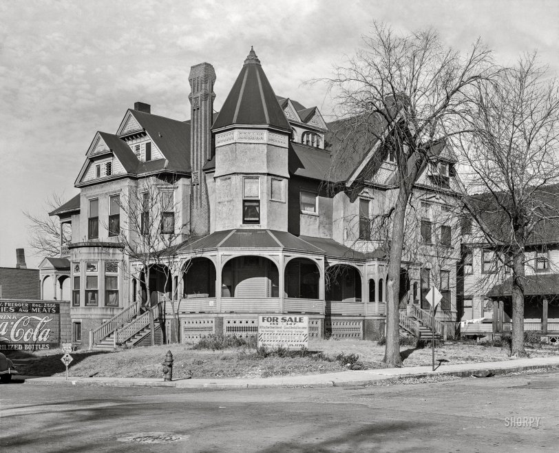
November 1938. "The old Paxton residence. Omaha, Nebraska." Medium format acetate negative by John Vachon for the Farm Security Administration. View full size.
Still there in 1955
Historic Aerials shows the old home still there in the 1955 imagery. The next newer imagery is 1969 and the lot looks to have been a parking lot by then.
Makes Sense To Me
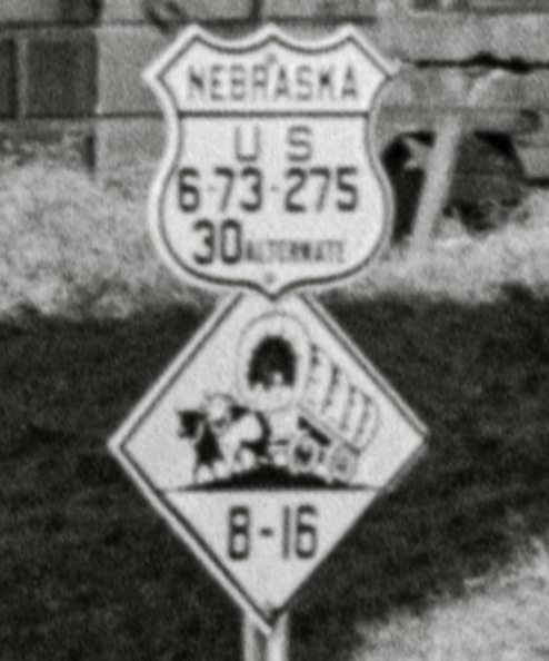
All four of those US highways are running "concurrent" through Omaha. They converged there, and will separate inside or out of the city. You don't need an arrow or turn instructions there because you have just passed through an intersection or junction and are now reading an "assurance" sign to let you know you are on the right path. Keep going and follow the signs. "Alt. 30" (or any other number) is nothing unusual in a city, even to this day.
It's All About Efficiency
It is commonplace in cities for numbered highway routes to converge and "run together" for a distance before separating. Nowadays in the USA, US routes have individual signs, sometimes resulting in dizzying arrays of 9 or 12 markers. Much more efficient to have one sign calling out four different routes, no? Similarly, the Nebraska state highway marker shows the conjunction of state routes 8 and 16.
Baffling signage
It seems strange to me, twelve years after state highway engineers came to some sort of consensus about nationwide standardized signage, that we had signs that were so illegible. We have a US route shield with four route numbers instead of one, and the word "alternate". We have a state route shield that looks like a caution sign, with an inexplicably graphic depiction of a covered wagon, and two barely-visible route numbers. And I don't understand how anyone ever thought it was a good idea to place route signage on a post so low that it could be obscured by a single parked car, and yet we see this repeatedly in pre-war photos.
Also, not shown here: the letters L or R, on a smaller US route shield beneath the numbered one, to indicate a left or right turn. Even if the engineers were that oblivious to non-English-speaking drivers, were arrows really that radical of an idea?
But I'm just barely old enough to remember the last few dozen miles of western highway not bypassed by Interstate, and I'll turn 52 tomorrow.
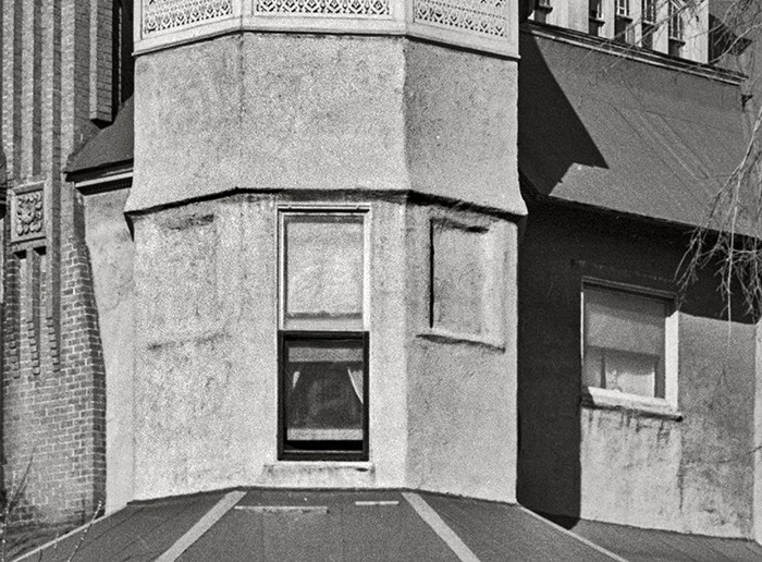
Budget Remodel
Need to get rid of some windows? Stucco 'em over!
Nebraska Highway
The sign with the covered wagon is a Nebraska state highway sign. The Oregon Trail wasn't even close. It ran west from Kansas City, crossed the Kansas River at Topeka, and then went northwest into Nebraska.
Brick art
That is one gorgeous chimney. It’s plenty of fun looking at the house, fantasizing about occupying it, but I keep coming back to that masterwork of brick.
Stae highway sign
The diamond shaped sign is a Nebraska state highway marker, which was adopted in 1926 and designed by state engineer Robert L. Cochran. The oxen-and-wagon symbol later became the official state symbol of Nebraska, according to Wikipedia. I can't tell however if the sign reads 8-16 or B-16 though.
Signs, signs, everywhere a sign
That has to be the busiest US Route sign I've seen. I learned A LOT about the US highway system running through Omaha figuring it out. With the wagon sign I am guessing the Oregon Trail ran very close by. Any idea on what "B-16" means? A position locator one could then reference?
Tough century
The 20th century was not kind to the Paxton family of Omaha. In July 1907, at the home at the corner of Douglas and South 25th Avenue, its patriarch William A. Paxton -- pioneer turned entrepreneur turned Gilded Age oligarch -- "was sitting in a great porch chair chatting and laughing in the best of spirits with his wife and the Misses Sharp, friends of the family" when "he gasped suddenly," nearly fell off the chair, and died of a heart attack. Their only son, William Paxton Jr., died unexpectedly of pneumonia less than three years later, in 1910. Son William left a wife (Georgia) and four-year-old adopted daughter, Prairie Paxton. His widow soon married a New York state senator, Martin Saxe, and in 1912 relocated with her young daughter to New York, leaving the great house and "many of her business interests" behind. Prairie Paxton married Randolph Day, gave birth to a daughter Georgia, suffered an illness for two years, and died in 1930 at age 24.
2556 Douglas Street
I can't tell if the Yeshia Fregger Grocery is incorporated into the house or in front of it, but either way, this would have been at the corner of Douglas and South 25th Avenue. Now an empty lot in a commercial area.









On Shorpy:
Today’s Top 5