

Framed or unframed, desk size to sofa size, printed by us in Arizona and Alabama since 2007. Explore now.
Shorpy is funded by you. Patreon contributors get an ad-free experience.
Learn more.

- Freeze Frame
- Texas Flyer wanted
- Just a Year Too Soon
- WWII -- Replacing men with women at the railroad crossing.
- Yes, Icing
- You kids drive me nuts!
- NOT An Easy Job
- I wonder
- Just add window boxes
- Icing Platform?
- Indiana Harbor Belt abides
- Freezing haze
- Corrections (for those who care)
- C&NW at Nelson
- Fallen Flags
- A dangerous job made worse
- Water Stop
- Passenger trains have right of way over freights?
- Coal
- Never ceases to amaze me.
- Still chuggin' (in model form)
- Great shot
- Westerly Breeze
- For the men, a trapeze
- Tickled
- Sense of loneliness ...
- 2 cents
- Charm City
- What an Outrage
- Brighton Park
Print Emporium
Going Back: 1942
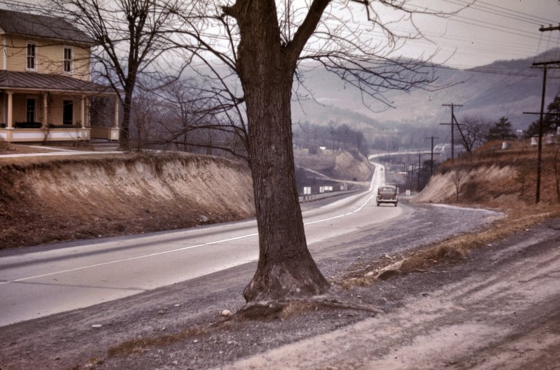
1942. "Road out of Romney, West Virginia." 35mm color transparency by John Vachon for the Office of War Information. View full size.
Romney, West Virginia: 1942
When I saw this photo, I could barely believe my eyes. In November of 1966, my 1964 Opal died at the bottom of the hill on this road. I was on my way from Colorado Springs to my Maryland home after serving a four-year hitch in the Air Force. I managed to coast to the side of the road. I walked back up to the house on the left to use the phone to call for help, but they didn’t have one. The next home up the road did. They called a garage a couple of miles away, and someone showed up a few minutes later. The guy said my points were defective, and that I would have to get the car fixed in Winchester, Virginia, where the nearest Buick/Opal dealer was. So I went back to the house and called the dealer, which was 50 miles away. They sent a tow truck out, and towed me and the car to Winchester. I stayed overnight in a motel. The dealer replaced the points the next day, and I headed home to Annapolis.
Then and Now
I have passed this scene many times over the years on our annual autumn trek to Blackwater Falls Park in West Virginia. In 2009, I stopped and spent about and hour reviewing this scene and comparing it to the Vachon photo. The scene today is almost identical to the Vachon view, with the following exceptions:
The bridge in the distance will soon be replaced by a modern one, but it remains in view;
The house on the left has collapsed, and nothing but rubble remains, hidden in the weeds;
And finally, the steep embankment on the right has been prettified by flowers and other plantings.
The roadway (Route 50) has never been widened or straightened out!
Almost Home
The bridge in the distance is over the South Branch of the Potomac River. I was born in the back room of a country store a few miles on down the road three years before this picture was taken.
The Yellow House
The satellite view from "Mountain Mama" (via Microsoft) is clearer than the Google version. It seems like that particular yellow house is gone, but it looks to me that the road is still two lanes - perhaps with a wider shoulder. And lots of homes still right along the road toward the center of town.
As posted in another thread, we need to setup a bounty service for a local to take a current photo!
I think I see it
I love Google Earth. I'm pretty sure that this is the bend in the road that we see in the photo. There is a bridge in the distance that also appears on the map, but the resolution is so low that I can't tell for sure if the house is still there. I couldn't figure out how to copy a link to the location on the Google Earth map, but here are the coordinates:
39°20'33.72"N
78°45'49.20"W
See if you agree.
dave
Indian Mound
This is the house seen here, across from the Indian Mound Cemetery. The houses are long gone. Route 50 was regraded, widened and straightened out many years ago. Satellite view.










On Shorpy:
Today’s Top 5