

Framed or unframed, desk size to sofa size, printed by us in Arizona and Alabama since 2007. Explore now.
Shorpy is funded by you. Patreon contributors get an ad-free experience.
Learn more.

- Freeze Frame
- Texas Flyer wanted
- Just a Year Too Soon
- WWII -- Replacing men with women at the railroad crossing.
- Yes, Icing
- You kids drive me nuts!
- NOT An Easy Job
- I wonder
- Just add window boxes
- Icing Platform?
- Indiana Harbor Belt abides
- Freezing haze
- Corrections (for those who care)
- C&NW at Nelson
- Fallen Flags
- A dangerous job made worse
- Water Stop
- Passenger trains have right of way over freights?
- Coal
- Never ceases to amaze me.
- Still chuggin' (in model form)
- Great shot
- Westerly Breeze
- For the men, a trapeze
- Tickled
- Sense of loneliness ...
- 2 cents
- Charm City
- What an Outrage
- Brighton Park
Print Emporium
C&O Canal (Colorized)c: 1925
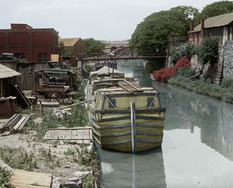
Glass Negative from the National Photo Company (Library Of Congress). View full size.
Correction to my previous comment and more information
I was wrong in identifying this as the Rock Creek Basin (as I did in a previous posting). It is indeed the canal in Georgetown upstream from the Wisconsin Avenue Bridge. However, the date is most likely 1923 as Key Bridge is in the background and appears to have been completed--it even has lamps on it. 1923 was the year that Key Bridge was completed. The canal was never opened to navigation in 1924 due to a late-March flood that hit before the boating season began, and a subsequent decision not to repair and reopen it. Thus 1923 was the last year for boating on the canal and the first year for Key Bridge, so the photograph would seem to be from 1923. It should be noted, however, that the 5-mile Georgetown level (from the Dam 1 Inlet beside Lock 5 to Rock Creek) was watered after the canal closed to navigation. That repair allowed the C&O Canal Co. to continue to sell water to the industries in Georgetown, which helped pay for the minimal employees retained until the canal was sold by receivers to the government in 1938. The canvas awning over the tiller deck and crew cabin, and the board for passing between the boat and the land, indicate that these boats were in use. So: It is not entirely impossible that they were in the canal in Georgetown in December, 1923, when it closed for the winter (no one knowing it would never reopen). Such boats could have been re-floated for some period of time in 1924 and subsequently until eventually broken up for salvage. It is known that some boats in the last decades of the canal were run by families too poor to have a winter residence and who resided year-around on their boat, Georgetown being one of the places they did so.
actual location and date
This is indeed a great picture. But, it is looking westbound and shows the Key Bridge in the background, not the Pa Ave bridge and everything else described previously by kmgrayphd.
This picture is taken from the footbridge over the canal that leads to the Dean & Deluca courtyard today. The footbridge in the foreground leads to 33rd street and the brick building on the right still exists today. A close look and you can see the 34th street footbridge as well. A small building at the left of the 34th street footbridge may be Henry Foxall's old "city house", or it may have been torn down already by this point and the building there just a brief intermediary.
Due to the existence of the Key Bridge, this photo is no earlier than 1924.
location and date
This is a great picture! It actually shows the Rock Creek basin for the C&O Canal. Note the Pennsylvania Ave. bridge over Rock Creek in the background. The canal proper begins at lock #1 which empties into Rock Creek a little ways down from the bridge (not visible upstream an on the left in this photo). The spit of land on the left was built by the C&O Canal Company and extended Rock Creek down to where the present mouth of the creek is. The original mouth was at K St. below Lock #1. At the new artificial mouth (behind the photographer) was tidelock and a low tumbling dam that created sufficient depth in the basin for the boats from the canal. The spit of land that now hosts the Thompson Boathouse was meant to be a transshipment point between boats using the Potomac and the canal boats. The canal was closed by a flood in March 1924 so I would date this photo c. 1920.










On Shorpy:
Today’s Top 5