

Framed or unframed, desk size to sofa size, printed by us in Arizona and Alabama since 2007. Explore now.
Shorpy is funded by you. Patreon contributors get an ad-free experience.
Learn more.

- Baldwin 62303
- Baldwin VO-1000
- Cold
- No expense spared
- Tough Guys
- Lost in Toyland
- And without gloves
- If I were a blindfolded time traveler
- Smoke Consumer Also Cooks
- Oh that stove!
- Possibly still there?
- What?!?
- $100 Reward
- Freeze Frame
- Texas Flyer wanted
- Just a Year Too Soon
- WWII -- Replacing men with women at the railroad crossing.
- Yes, Icing
- You kids drive me nuts!
- NOT An Easy Job
- I wonder
- Just add window boxes
- Icing Platform?
- Indiana Harbor Belt abides
- Freezing haze
- Corrections (for those who care)
- C&NW at Nelson
- Fallen Flags
- A dangerous job made worse
- Water Stop
Print Emporium
Mass. Transit: 1912
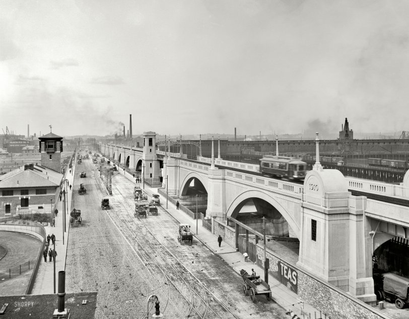
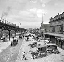
Boston circa 1912. "East Cambridge Bridge." A visual compendium of ways to get from here to there. 8x10 glass negative, Detroit Publishing Co. View full size.
The poles
The trolley viaduct opened in June 1912. The draw in the Cragie bridge is there, it is just hard to see. Those poles in the middle of the road are to lift the trolley wire when the bridge opens, and to realign it when span closes.
101 years and still on the move
The location is in Boston, at the old Charles River Dam, which is visible as an earth rampart at the left, behind the tower with the weathervane. The trolley viaduct is in current use as part of the MBTA Green Line service. At the viaduct's end, you can see the still-existing ramp down across the roadway to Lechmere station.
In the roadway below, currently known as Monsignor O'Brien Highway and Route 28, it looks like they haven't yet installed the Craigie Drawbridge (though they've installed the traffic control gates for the streetcar, the sidewalks look like they're still solid instead of part of a drawbridge). Also interesting is the high drawbridge built into the trolley viaduct, to accommodate sailboats entering the Charles River.
The Metropolitan District Commission building on the left (which now houses state police) has the control tower with the weathervane on top. The viaduct drawbridge is no longer operational (but the ironwork is still there), and the one in the roadway is being rebuilt right now, in a project running November 2010 through April 2011.
The two buildings at the left edge of the photo, just in front of Wellington-Wildwood Coal, are an MDC stable and boathouse. The stable is now used for work trucks by the Dept. of Conservation and Recreation, which is the renamed MDC, and the boathouse at far left is empty and deteriorating. The view of these buildings would now be blocked by the Museum of Science and its garage.
Behind the coal company building and a little to the right is the square tower (with peaked roof) of the Clerk of Courts building in Cambridge, with the main courthouse next door not visible.
Everything to the right of the viaduct is gone and changed, though there's still a major railroad crossing there for traffic to North Station.
"New" History
How cool it must have been to witness a construction project of this scope knowing that there probably isn't another of its type anywhere nearby. It reminds me of seeing I-75 south of Detroit being built at the end of my street in the mid 1960's where there was never a freeway before.
Five out of seven
possible methods of transportation shown here. Steam powered
rail, electric trolley, horse-drawn vehicles, motorized vehicles, and walking! Surprisingly, I couldn't spot anyone on a bicycle, nor could I see any boats in the water.
[Let us not forget the aeroplane. - Dave]
Bridge over the River Charles
I was surprised to see that the arches of this bridge were originally much narrower than they are today. (Although you can see the 1910 date has been retained.) Trolleys still run on that bridge, although it's now the only section left of a much longer elevated track that was mostly put underground during the Big Dig. There is also a drawbridge on the roadway now for boats to pass through, although it very rarely goes up these days -- mostly only on the Fourth of July when yachts come in from the harbor to watch the fireworks.
The building on the left is now a State Police outpost (perhaps it was then, too.) The Museum of Science now occupies the open space behind it.
Sensational!
Remarkably, much of what is depicted in this photograph, which looks from Boston back across the Charles River to Cambridge, remains in place. Most prominently, the poured concrete viaduct for the trolley (today, referred to as the Green Line) running along the right side of the photo, is still there. I have often looked at the "1910" date engraved on the arched pediment above the column at the far right, and wondered what this part of town must have looked like when this structure was new. There is currently a drawbridge in the location where the police officer is standing in the middle of the road, in order to let sail boats get through from the Charles River (to the left) out to the Boston Harbor (to the right). The drawbridge is currently being rebuilt, and this section of road is actually closed for traffic for the next several weeks. The buildings on the left are still there as well. The tower is used (I believe) to control the drawbridge, and the lower building serves as a State Police station. A few weeks ago, a car was passing underneath the archway at the far right of the photograph, and a large chunk of concrete fell from above and shattered the driver's rear windshield. The whole structure still has a wonderful look to it, but it does need some attention.
Beauty lost to time
Not much has changed
The trolley track viaduct is still there. The building on the left with the tower still exists. It overlooks the Charles River dam. It still has a drawbridge over the connection lock between the river and Boston Harbor. Farther up on the left past the tower is now the location of the Boston Museum of Science.










On Shorpy:
Today’s Top 5