


Framed or unframed, desk size to sofa size, printed by us in Arizona and Alabama since 2007. Explore now.
Shorpy is funded by you. Patreon contributors get an ad-free experience.
Learn more.

- Baldwin 62303
- Baldwin VO-1000
- Cold
- No expense spared
- Tough Guys
- Lost in Toyland
- And without gloves
- If I were a blindfolded time traveler
- Smoke Consumer Also Cooks
- Oh that stove!
- Possibly still there?
- What?!?
- $100 Reward
- Freeze Frame
- Texas Flyer wanted
- Just a Year Too Soon
- WWII -- Replacing men with women at the railroad crossing.
- Yes, Icing
- You kids drive me nuts!
- NOT An Easy Job
- I wonder
- Just add window boxes
- Icing Platform?
- Indiana Harbor Belt abides
- Freezing haze
- Corrections (for those who care)
- C&NW at Nelson
- Fallen Flags
- A dangerous job made worse
- Water Stop
Print Emporium
Smallville: 1937
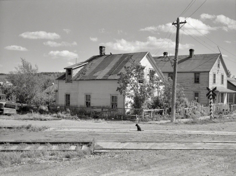
August 1937. "Houses in Winton, Minnesota -- lumber bust town." A two-house town, on a two-dog day. Another example of prolific shooter Russell Lee's work. Medium-format negative for the Resettlement Administration. View full size.
Dog on the line.
Russell Lee is more than simply prolific. He's one of the great American artists of the 20th century. What an eye! This photo is so rich in capturing the 1937 moment in far northern Minnesota.
Oops, I Goofed
After reading the comments by mdemming and RadioMattM. I rechecked myself.
I originally looked at the Historic Aerials 1939 Topo map which only showed a single line for the railroad. However, I have now looked at Topo maps for other years. On the Historic Aerials 1986 Topo map, it shows the double track railroad lines. The only diagonal street crossing was at where Main Street bisects East and West 3rd Avenues. In this new Google Map view, the first house stood at where the liquor store is now located. The second house in the original photo is still standing, adjacent to the liquor store.
RadioMattM, the shadows now match up in both the modern street view and the 1937 photo.
I apologize for my previous error.
JellyBelly
PS: Regarding the Winton depot, it was moved from it's original location. Which by logic would have been at 3rd and Main.
https://maps.google.com/maps?q=Winton,+Minn&hl=en&ll=47.927425,-91.80057...
Well maybe not
If you go here
http://www.historicaerials.com/
and type in Winton Minnesota you can see where the railroad is and it is about a block north of either map location. If you zoom out of street view you can see where the line used to go. Rail lines even when abandon and pulled up leave tell tail signs. Especially when you have done many years of research on old rail lines like I have.
If you are right
the road heads due north, meaning the wall facing the tracks faces due south -- but it is in a shadow.
A agree that the hill in the background looks right, and the mention of the pole is plausible, but I just can't figure out the shadow.
The significance of utility pole lines
"My experience from years of research have proven that utility pole lines very rarely change."
JellyBelly, thank you for mentioning that - it's extremely interesting. Yet another example of useful information just kind of casually passed on by a Shorpy member. What a wonderful site.
Do you think the pole lines stay the same because once utility easements are established changing them is difficult? My very limited experience with utility easements in San Diego was that getting the utility company to abandon one was essentially impossible even decades after they'd quit using it.
Smallville Today
This might be the spot: http://goo.gl/maps/0lzA9
The angled gravel drive in the foreground appears to follow the old railbed, and looks like the only place where the railroad might have crossed a street at an angle. Alas, our two handsome little houses are not there.
From west to east, the old railbed appears to angle into town along Amazon Drive, then straightens out at West Street between 2nd and 3rd. From there it proceeds to the depot on Lake Street, now the home of Fat Chicken Feed Store.
What It Looks Like Today
After consulting a Topo map dated 1939. This is the location of that photo. The dirt road to the left is the old right of way for the railroad. Also, note the light pole on the left. My experience from years of research have proven that utility pole lines very rarely change. Even after a railroad line or public road has been abandoned. The pole lines will still remain.










On Shorpy:
Today’s Top 5