


Framed or unframed, desk size to sofa size, printed by us in Arizona and Alabama since 2007. Explore now.
Shorpy is funded by you. Patreon contributors get an ad-free experience.
Learn more.

- Details, Details
- What's that building to the left of the tower?
- Coal Barges
- Bromo-Seltzer
- Inner harbor
- The Basin
- What a headache!
- Giant stepladder?
- Baldwin 62303
- Baldwin VO-1000
- Cold
- No expense spared
- Tough Guys
- Lost in Toyland
- And without gloves
- If I were a blindfolded time traveler
- Smoke Consumer Also Cooks
- Oh that stove!
- Possibly still there?
- What?!?
- $100 Reward
- Freeze Frame
- Texas Flyer wanted
- Just a Year Too Soon
- WWII -- Replacing men with women at the railroad crossing.
- Yes, Icing
- You kids drive me nuts!
- NOT An Easy Job
- I wonder
- Just add window boxes
Print Emporium
Ghosts of State Street: 1908
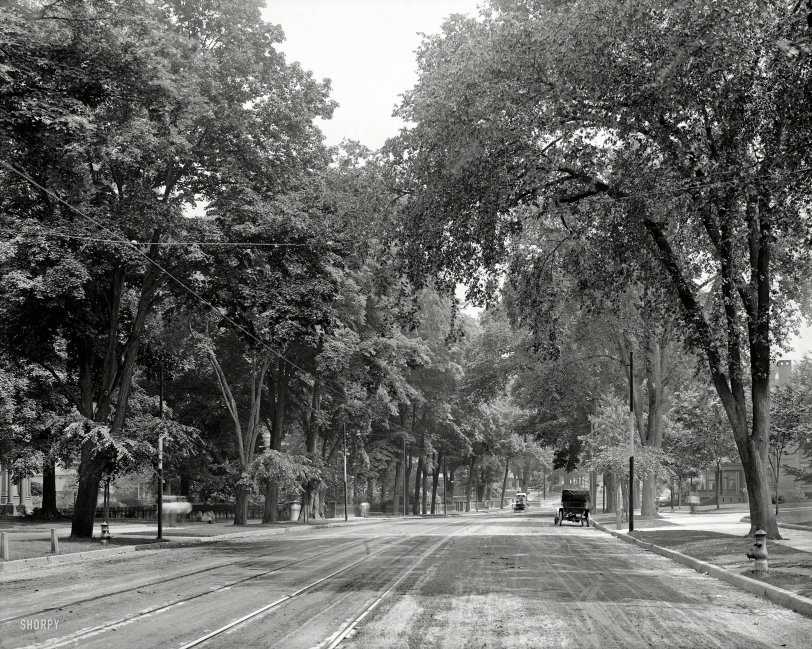
Circa 1908. "State Street -- Springfield, Massachusetts." The long-departed denizens of this leafy enclave can be seen going about their blurry business with ectoplasmic flair in this exposure lasting perhaps two or three seconds. 8x10 inch dry plate glass negative, Detroit Publishing Company. View full size.
More on Location
To build some more on what I suggested earlier and what Jeffery elaborated on, I think I have found something that may be proof of the location in the distance on the left as the Armory, which is next to the college today that I mentioned. I think we were only a block or so apart in our guesses. The two stone gate posts at the entrance to the armory can be found at 394 State St. on the left side of a Google street image today. There is only the right stone pillar in existance today, the left apparently demolished at some time. Their shape and appearance is the same. There is also clear evidence that the grade and width of State St. was modified considerably since the Shorpy photo.
Nice Detective Work, Jeffrey!
Kudos to Jeffrey Jakucyk! I was looking at topo maps and Google Maps trying to figure it out and I couldn't. So much has changed that the street now has hardly any curvature or slope. I did find the house with the pillars, but everything else was so different that I just didn't believe I was in the right place.
There was a discussion about Maple Place. I couldn't find that, but I did find that between the time of the topo map and Google Maps, Maple street had been extended. But it didn't seem to intersect State Street in the right place for the old photo.
If this had been the "Indiana Railroads Bull Session" forum, this photo would have been prime for a "Wherezitat?" post...
Telephoto Tricks
In the distance above the carriage on the left side of the street is the gated entrance to the armory at Byers Street. http://goo.gl/maps/bjo7h
If you look around you can see some of the other houses. On the extreme left there's two columns and a bay window. That would appear to be the house at the corner of Elliot Street (note the fence line running perpendicular to State). That's right next to St. Michael's Cathedral, maybe the rectory? http://goo.gl/maps/ZSfK0
On the right is a house with a porch that has three columns at each corner. In the current view there's still some of that funky curb along the edge of the sidewalk. It also shows that the already excessively wide street was widened even further at some point, removing the planting strip that supported the stately elm trees. http://goo.gl/maps/loL4V
So the photographer had to be back almost to Chestnut Street, some three or four blocks from Byers. The curve in the street and the change in grade is nearly imperceptible on the wide angle Google street view images. As for the street sign? Maybe an alley or small street that has since been abandoned and absorbed into the parking lot to the right of the house with the three columned porch.
Wide sidewalks
You know your neighborhood is upscale when your sidewalks have curbs.
Hydrants clue
Sanborn Fire Insurance Maps contain a lot of details like hydrants and street names and easements. Find out which Springfield library has the Sanborn maps to help identify this location.
Those beautiful elm trees.
Mostly gone now, thanks to Durtch elm disease. I can remember when the streets here in Milwaukee were lined with them, just like in the picture.
Elm Tunnel
Many cities had lovely elm trees with the distinctive vase shape creating leafy canopies over streets. The late 1920's saw the spreading of elm disease that sadly all but wiped out these beautiful trees.
Location Wild Guess
Emphasis on the "wild", but here goes. We all know that the affluent areas in most towns 100 years ago were on a main boulevard not too far from the city center as you left town. Based on that, the tree shadows showing we are looking NE, and the rightward bend in State St just beyond, I suspect this is near the current location of Springfield Technical Community College. Today, the college would dominate the left side of the photo, just prior to the rightward bend of State St.
Mystery location
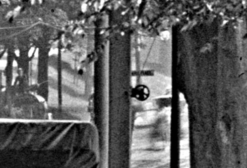
I'm puzzled. This view appears to contain a slight downhill grade and a slight bend to the right, which is a clue to its location. A better clue is the street sign near the car on the right (magnified and contrast-enhanced below) - it appears to be (something) Place, where (something) looks an awful lot like "Maple." Problem is, I've looked at maps of Springfield from 1870 through 1940 (and 1908-1909 in particular), and can find only one street crossing State that is designated "Place" - Hunter Place, which doesn't look right at all. (There may also have once been a "Courthouse Place" near the river, but if that even existed, it also looks completely wrong.) I've found a few stretches of State Street that have roughly the right topography, but I have yet to find any other corroborating clues. It's a head scratcher...
Hydrants
If anyone comes up with a general location of this photo, the fire hydrants may help in nailing down the specific spot. Hydrants are rarely relocated or removed once installed.
I wonder where
I grew up in Springfield in the 50s and early 60s and I sure can't fathom where on State Street that may have been taken. I can't think of any part of State Street where such an idyllic scene could have existed 50 years earlier.
We have lost so much in the past century...
I wish
There is something about the beauty of this street under these trees next to these gracious homes that makes me so want to transport myself there, if only for a brief moment. Has life ever been as peaceful and serene since?













On Shorpy:
Today’s Top 5