

Framed or unframed, desk size to sofa size, printed by us in Arizona and Alabama since 2007. Explore now.
Shorpy is funded by you. Patreon contributors get an ad-free experience.
Learn more.

- Baldwin 62303
- Baldwin VO-1000
- Cold
- No expense spared
- Tough Guys
- Lost in Toyland
- And without gloves
- If I were a blindfolded time traveler
- Smoke Consumer Also Cooks
- Oh that stove!
- Possibly still there?
- What?!?
- $100 Reward
- Freeze Frame
- Texas Flyer wanted
- Just a Year Too Soon
- WWII -- Replacing men with women at the railroad crossing.
- Yes, Icing
- You kids drive me nuts!
- NOT An Easy Job
- I wonder
- Just add window boxes
- Icing Platform?
- Indiana Harbor Belt abides
- Freezing haze
- Corrections (for those who care)
- C&NW at Nelson
- Fallen Flags
- A dangerous job made worse
- Water Stop
Print Emporium
Midcentury Manhattan: 1950
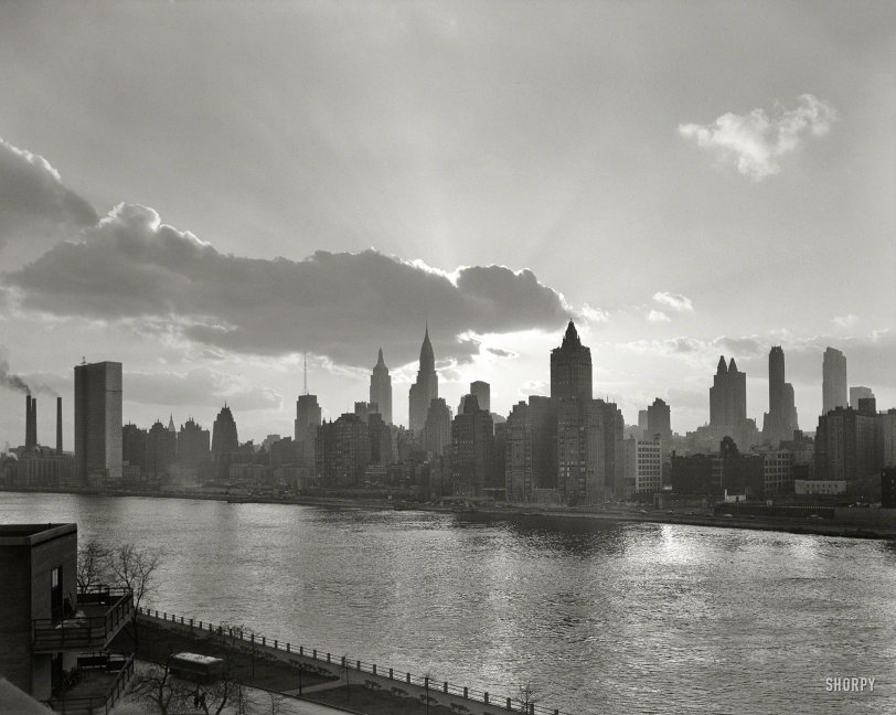
March 14, 1950. "New York City views. Manhattan skyline from City Hospital." Large-format acetate negative by Gottscho-Schleisner. View full size.
Quiet City
The piece of music that comes to my mind is Copland's Quiet City. http://www.youtube.com/watch?v=Gu06sqSIRdE
Gottscho
I try to figure out what it is that makes Gottscho's photos so instantly identifiable as his own: the lighting? the subject? the New York spirit that he captures so well and transmits in his own unmistakable style? All I know is that when I go to the always-open Shorpy tab and hit Refresh and see the Gottscho image appear, my pulse quickens and I embiggen the photo with slack-jawed wonderment. (Thanks to Peter, as well, for the very fine skyline guides.)
George Gershwin
I cannot look at this picture without hearing "Rhapsody In Blue" going through my head, even though that magnificent song was 26 years old in 1950. Seems like every movie I ever saw about N.Y. used that musical theme.
Some landmarks
At far left are the smokestacks of the electric power plant that occupied the east side of First Avenue between 38th and 40th street until just a few years ago. Next is the UN Secretariat, a couple years away from completion. At the time, the UN's temporary headquarters was just across the Nassau County line in Lake Success, in a former industrial building that's now an office park. Trivia: prior to the start of construction in 1947, the UN site shown here was occupied by a slaughterhouse.
A bit to the UN's right, among the buildings of the Tudor City apartment complex, the upper part of the Metropolitan Life tower can be glimpsed. Located a mile south of the UN, it was built in 1909 and had been the world's tallest building for a few years. Moving on to the right, the Empire State and Chrysler buildings are obvious. The building in the foreground with the rounded tower and two large wings facing the camera is a (very) luxurious apartment building with a 52nd Street address known as Riverhouse. It used to have its own yacht basin on the East River, but that was lost with the construction of the FDR Drive in the 1930's. The building with two towers further to the right is the Waldorf-Astoria Hotel.
One building that's a bit harder to identify is the squarish building slightly left of center with the huge antenna on top. I believe it is the 37-story Daily News building at 220 East 42nd Street, built in 1930, as it was one of the relatively few pre-1950's buildings in Midtown with a flat roofline, and the big antenna would make sense on a newspaper's headquarters. I'm not completely sure, however.
Welfare/Roosevelt Island lacked direct road access until a bridge from Queens opened in the early 1950's. The Queensboro Bridge (now known as the Ed Koch Queensboro Bridge) ran over the island starting in 1909, but was too high above the surface for a direct exit to be feasible. Instead, the trolleys which ran across the bridge stopped at a mid-span station called the "Upside Down House," from which elevators and stairs allowed people to descend to ground level on the island. In 1930 some of the elevators were modified to accommodate vehicles, enabling ambulances to bring patients to the island's hospitals. Trolley and elevator service ended when the bridge from Queens opened and the Upside Down House was demolished around 1970.
New Desktop Material
This is just an amazingly wonderful photo. Strangely enough, the nearly-completed United Nations Building off to the left looks incredibly out of place with the other gothic and art-deco structures in New York's skyline.
FDR
Was it still called Welfare Island in 1950? Look how light traffic was on the East River Drive!
[Renamed Roosevelt Island in 1973. -tterrace]
Exquisite
The man certainly knew how to make light work to improve the shot. Breathtaking.
East River Enclave
City Hospital, the site from which this was photographed, was on Welfare Island, sandwiched between Manhattan and Queens. The hospital was also known at one time as Penitentiary Hospital. It was closed in 1957 and was finally demolished in 1994. Welfare Island, formerly known as Blackwell Island finally morphed into Roosevelt Island, is a now a residential district with great view of Manhattan. It lobbied the city and was granted a Manhattan Zip Code, 10044 and area code, 212. It is connected to the Manhattan from the east by an aerial tram and from the Queens side by subway and bus.







On Shorpy:
Today’s Top 5