


Framed or unframed, desk size to sofa size, printed by us in Arizona and Alabama since 2007. Explore now.
Shorpy is funded by you. Patreon contributors get an ad-free experience.
Learn more.

- S&P
- 1940 Zenith radio model 6G601
- Quality goes in before the name goes on!
- Snazzy skirt
- Carbon Arc Lamps
- Illuminate us
- I remember it well
- I can't prove it
- Complicated then, forgotten now
- Bryan-Stevenson
- Skinny is as skinny does
- How do you rest in peace
- Riding the footboards
- Alas, hidden from view
- Baldwin Diesels
- Exclusive pump
- Bananas, Oysters and Smokey Joe
- Details, Details
- What's that building to the left of the tower?
- Coal Barges
- Bromo-Seltzer
- Inner harbor
- The Basin
- What a headache!
- Giant stepladder?
- Yeah, it was cold
- Love those coats
- Link & Pin Days Remnant
- Baldwin 62303
- Baldwin VO-1000
Print Emporium
Intimations of Autumn: 1952
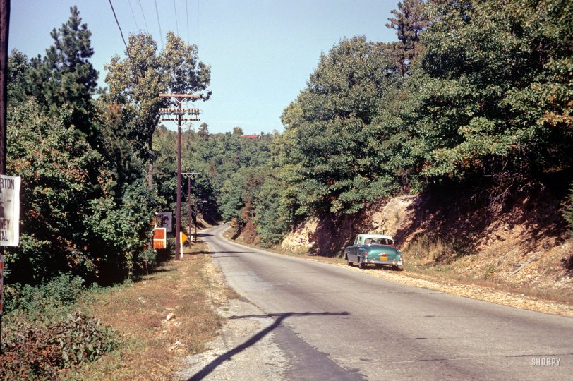
UPDATE: Shorpy member SteamBoomer has correctly identified the location as Eureka Springs, Arkansas. See the Comments for details.
"7 Oct. 1952 -- Entrance to ______ _______." Who can tell us where we are in this latest installment of Minnesota Kodachromes? (Hint: not Minnesota.) 35mm color slide by Hubert Tuttle, on the road with wife Grace. View full size.
Eureka Springs, 1904
Family outing, 110 years ago:
Eureka!
SteamBoomer seems to have nailed it. The irony for me is that I was originally convinced that this was one of the roads in the state I grew up in, California. Instead, it turns out to be in the one town in Arkansas that also figured in my childhood. I spent a few summers in Eureka Springs staying with relatives. I remember the beautiful buildings and houses of the town well, but I'd forgotten the wild look of the countryside around it.
They hit Iowa on the way home from the trip.
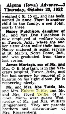
I was going to guess Iowa, due to this article which places them in Iowa not very long after this photo was taken:
[I suspect Iowa was on both both legs of their trip! - Dave]
Entrance to Eureka Springs
Hubert and Grace have turned north off US Hwy 62 onto Arkansas Hwy 23. The photo was taken somewhere around GPS coordinates 36.394231,-93.742166.
[Now that's what I call specific. And correct! How did you figure it out? - Dave]
I simply had a Eureka moment!
Ouachita
Could it be Ouachita National Forest in Arkansas?
Strange if California
The foliage definitely looks like California, but if that is a US Highway sign whose back we see things are a bit odd. My memory was, and checking the online 1952 highway map verified, that there were relatively few US Highways in California in 1952, none were designated Alternate, and all were relatively main roads. (Except for good old US 395 to Alturas, which had sections listed as oiled dirt or oiled gravel.) If it was a state or county road it's unlikely but possible that a stretch that long would not have a distance marker (we called them "paddle signs" in the rally game) showing. Nifty puzzle.
Warm Springs?
Going by your hints, is it Warm Springs, Georgia?
[Getting colder. Brrr! - Dave]
Reading the hints
Warm Springs, Georgia? It's on my mind.
My vote - not California
Two things I see, both road-related:
1. California's two auto clubs (and the Division of Highways beginning in 1948) were in charge of road signage and paid meticulous attention to detail in doing so. That yellow diamond sign would've been mounted to a post painted yellow to match with black at the base.
2. If this is indeed a US highway, there would likely be white striping down the center of the roadway, even if it wasn't quite wide enough for two full lanes.
Agree with Mbillard
As you suggested Dave, find the one who lost the election. Glib Barton fits the bill. As for the fill in the blanks, how about "Ozark Mountains"?
[Not quite. And Clib wasn't Glib. - Dave]
Hot Springs to Win
Yes, it must be Hot Springs. Hot Springs has had a horse track since 1905, Oaklawn Park.
[You're not even Warm. - Dave]
Route 120 in California
Based on the vegetation (the near pines are Ponderosa pine and there are a couple of digger pine along the horizon), the madrone near the electric pole of the near left. I guess it to be somewhere around Groveland, CA on the road to Yosemite Park.
Let's go to Hot Springs (Ark.)
Looks a lot like an Arkansas highway, plus the sign with the racehorse on it indicates they are on the way to Hot Springs which has a major thoroughbred race track and is on Highway 7.
Route 120 in California
There are ponderosa pine, digger pine, madrone and black oak (I believe) in the picture, all native to California. I'm going with Route 120 on the way to Yosemite Park out of Groveland, CA. 3500 foot elevation because everything is still green in October.
Glib Barton
ran for Attorney General in Arkansas in 1952, so I'm going to cast my vote for Arkansas, as well.
[Ahem. CLIB Barton. - Dave]
Folger Stable and Wunderlich Park
I think we are on what is now SR 84 North, Woodside Road, Redwood City, San Mateo County, California. The election poster seems to be for Atherton. The entrance to the left is for the Folger Stable, where one could hire a horse and take the equestrian trails through Wunderlich Park.
Florida?
Forgive me if this a stupid suggestion (I'm a Brit and have visted parts of the US but not Florida). Someone named L.Grady Burton stood for Attorney General in Florida in 1948*. If elections are every 4 years he may have stood again in 1952. Does this help?
*Daytona Beach Morning Journal - May 21, 1948.
Trees suggest not California
I'm pretty sure I see post oak, black oak and shortleaf pine. I could be wrong, but I'm going to go out "on a limb" and say its the entrance to "The Ozarks".
Wonder Spot
Lake Delton, Wisconsin, just south of the Wisconsin Dells.
US 12
Looking from the rocks and trees, could they be on US-12 south of Baraboo, WI on their way to Devil's Lake State Park?
Process of Elimination
If the election poster is for state Attorney General, then California can't be the state. Pat Brown was elected in 1950 and didn't run again until 1954. There was a State Attorney General elected in Oregon named Thornton in 1952, but the last four letters of the last name on the poster are definitely "RTON".
[Interesting, but knowing who got elected doesn't help you much if the guy on the poster lost. - Dave]
I'm going with California, somewhere.
The trees on the right look like Madrone or large Manzanita. There are some pines floating around in the trees as well as what could be a tallish live oak. The cut bank of dirt looks like the kind where I grew up. I'm going with North Central California. No idea as to the entrance.
Maybe not so far away
It's 1952 and these are our friends whose previous photos have always been in southern Minnesota. Not Minnesota? OK, how about western Wisconsin, someplace between the Twin Cities and Eau Claire?
California? Near a polo field?
Judging from the trees (is that a madrone on the near left?) I would say coastal California. It's a bit lush to be Southern California. My guess would be near Santa Cruz. The sign with the horse icon on the left looks to me like a sign for polo grounds, rather than horse riding or racing. The area around the Polo Grounds Park in Aptos looks similar, but I couldn't find a road that matched that topography.
Too green?
I think it may be too green for the photo to have been taken in New England in October. Farther south, I think. I would be tempted to say, "entrance to Blue Ridge Parkway" if there were three spaces.
Highway sign
Down the road a piece we see what looks like a shield-shaped US Highway number sign with an auxiliary above. The latter could be "NORTH," "SOUTH," "ALT(ernate)" etc. My guess is "alternate," specifically the earlier main route, based on the narrowness and the 1920s-1930s-era cement pavement, and since bypassed by a wider, straighter roadway.
Of course, this only narrows the location down to the entire United States. There's something about the nearest trees at the right that says California live oaks to me, but I can't quite make out the leaf shape.
If only we could see a little farther left
From the trees and the rocky terrain my best guess is that this is somewhere in Upstate New York or northern New England. What makes the guessing game especially tantalizing is the sign partly visible at far left. Someone named Horton or Morton or Norton was running for state attorney general in the 1952 election. Here's hoping Wikipedia has enough detail ...
[Edit: as another person helpfully noted, this could not be Upstate New York or northern New England in October. I should have known that.]
[Further edit: the suggestion of Florida is an intriguing one, and there are some areas north of Orlando that might be hilly enough, but the rocky outcroppings at the right wouldn't be found in the Sunshine State.]










On Shorpy:
Today’s Top 5