


Framed or unframed, desk size to sofa size, printed by us in Arizona and Alabama since 2007. Explore now.
Shorpy is funded by you. Patreon contributors get an ad-free experience.
Learn more.


- If You’re Like Me, Never
- U.S.A.
- S&P
- 1940 Zenith radio model 6G601
- Quality goes in before the name goes on!
- Snazzy skirt
- Carbon Arc Lamps
- Illuminate us
- I remember it well
- I can't prove it
- Complicated then, forgotten now
- Bryan-Stevenson
- Skinny is as skinny does
- How do you rest in peace
- Riding the footboards
- Alas, hidden from view
- Baldwin Diesels
- Exclusive pump
- Bananas, Oysters and Smokey Joe
- Details, Details
- What's that building to the left of the tower?
- Coal Barges
- Bromo-Seltzer
- Inner harbor
- The Basin
- What a headache!
- Giant stepladder?
- Yeah, it was cold
- Love those coats
- Link & Pin Days Remnant

Photos submitted by Shorpy members!
Print Emporium


Road Tripping: 1952

"6 Oct 1952. Clara & Grace at chenille & souvenir shop south of _______ ." We're back with Hubert and Grace on their road trip from Minnesota, the day before our previous photo was made at Eureka Springs, Arkansas. Where are we now? 35mm Kodachrome by Hubert Tuttle; paint by Dr. Seuss. View full size.
JCT A
Since the Missouri DOT doesn't have money to pave roads anymore, they have lots of time to do things like scan all of the old state highway maps. The '48/'49 and '53 maps confirm that there was never a Route T near Phillipsburg. In '49, Route T went all the way from Montreal (Missouri) to Route 66, but by '53, part of it was replaced by Missouri 35. The south end of that Route T being in Laclede County precludes there being another Route T in Laclede County that isn't connected to it.
My further guess would be that this is between Phillipsburg and Lebanon, because 1) the shadows say we are looking more or less north and 2) we can see the *backs* of signs that are advertising the wonders to be found to the south.
I spent a little time with Google Street View looking for that hill, but nothing jumped out at me. It's possible that the hill was eased when I-44 went through - the interstate would be pretty much right where Clara and Grace are standing.
Route 66 Novelty Merchant
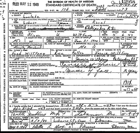
This is probably the home/business of Novelty Merchant Oliver U. Wiltfong in rural Lebanon area of Missouri.
Oliver (and wife Jessie) lived in rural Lebanon, Laclede County, Missouri, for about 2 years prior to Oliver's death from brain cancer on May 6, 1949.
They resided near Phillipsburg, a village of about 200 population southwest of Lebanon along U.S. Route 66 (now I-44). Postal address: Phillipsburg Rt I.
Assuming Jessie remained living in Phillipsburg after Oliver's death, at the time this photo was taken in 1952 I would venture to say this is probably the family home on Route 66 near Phillipsburg.
During the 1940/50s is was customary for folks living along Route 66 to sell novelties from their yards to passing travelers.
[The old Route 66, now State Highway W, parallels I-44 near Lebanon, Missouri, the town whose name fills in the blank in our caption. Below is Oliver's death certificate; click to enlarge. His address is given as Phillipsburg Route T, presumably State Highway T in the vicinity of Phillipsburg. - Dave]
[Dave - *Missouri T* is north of Lebanon. It runs south from Stoutland, MO to old Route 66 where it ends. Hence my conclusion the address on the Death Certificate is a U.S. Post Office mailing address (not a highway route). It's doubtful *Missouri T* ever ran all the way down to Phillipsburg, MO (unless since the 1940/50s the State renamed all the highways).
Common sense says to me that since Oliver sold novelties he would locate on old Route 66 for maximum traveler traffic. Few travelers ventured off of Route 66 particularly in rural areas (except to visit major attractions).
The building in the photo appears to be an old barn or shed dressed up a bit as a novelty shop by adding a false front and roof over hang. Notice the arched front vs. the pitched metal roof on the building; and, the double swinging barn type doors at the front of the building.
During the early to late 1950s my family traveled Route 66 annually from California to Missouri on vacations to visit family living in Missouri. The highway shown in the photo is what Route 66 was like most of the way from Chicago to California - a two lane concrete and/or asphalt highway.
The mail box with the name *O. Wiltfong* on it leads me to believe this is the property where Oliver and Jessie lived on old Route 66; and, that they converted an out building to a novelty shop.
All of this leads me to believe the photo was taken at the Wiltfong residence (and novelty shop) on old Route 66 in Phillipsburg, MO southwest of Lebanon, MO. - SilverfoxCo ]
Oliver!
Oliver Wiltfong, born in 1900, was living in Blue Springs, Missouri, in 1920. In 1940, he was in St. Louis. Perhaps Ollie ended up at this roadside oddity by the time this pic was taken.
I know where they are.
Just outside of Hooterville.
Country Roads
Back when I was a lad, American highway lanes were separated by a white line (broken or solid as appropriate), as shown here. Somewhere along the line, the white of those lines was replaced with yellow, and white was retained only for separating same-direction lanes on multiple-lane roads. Apparently this was a change I completely slept through, because I can't place the time when it took place.
I wonder if anyone out there can pinpoint when this change occurred. The reason I'd like to know is that I find it irksome when "period" movies show yellow lines on putatively vintage roads (much like showing red/blue mailboxes in an era when they should be green), and I'd like to know at what portrayed period I can relax in this regard and, therefore, not feel an oppressing need to get a life.
[That bugs me in period movies, too. The change from white to yellow began in 1971 when the Federal Highway Administration assumed responsibility for the Manual on Uniform Traffic Control Devices. Everything you ever wanted to know about it is in this document. -tterrace]
Not as rare a name as I thought
I had thought that Wiltfong was a very rare name that might provide a location clue, but an online search shows well over 100 people with that surname. While they're located all over the place, there are a number in Missouri, which ties in with a prior comment. Someplace to the north of Eureka Springs also would make sense given the way the trees have turned more in this picture.
[What about "O. Wiltfong" -- are there hundreds of them? -Dave]
[Edit: No O's that I could find. Probably wouldn't matter, as the O in this picture has likely been long since gathered to his/her ancestors.]
[It does matter, if you're trying to figure out where this is. - Dave]
How About This?
Back then, the way to get from Minnesota to Eureka Springs, Arkansas was along Highway 65. Given that people in 1952 didn't travel as far in a day as we do, I'm going to guess this is around Sedalia, Missouri.
On Shorpy:
Today’s Top 5