


Framed or unframed, desk size to sofa size, printed by us in Arizona and Alabama since 2007. Explore now.
Shorpy is funded by you. Patreon contributors get an ad-free experience.
Learn more.

- Details, Details
- What's that building to the left of the tower?
- Coal Barges
- Bromo-Seltzer
- Inner harbor
- The Basin
- What a headache!
- Giant stepladder?
- Baldwin 62303
- Baldwin VO-1000
- Cold
- No expense spared
- Tough Guys
- Lost in Toyland
- And without gloves
- If I were a blindfolded time traveler
- Smoke Consumer Also Cooks
- Oh that stove!
- Possibly still there?
- What?!?
- $100 Reward
- Freeze Frame
- Texas Flyer wanted
- Just a Year Too Soon
- WWII -- Replacing men with women at the railroad crossing.
- Yes, Icing
- You kids drive me nuts!
- NOT An Easy Job
- I wonder
- Just add window boxes
Print Emporium
Coal Hole: 1938
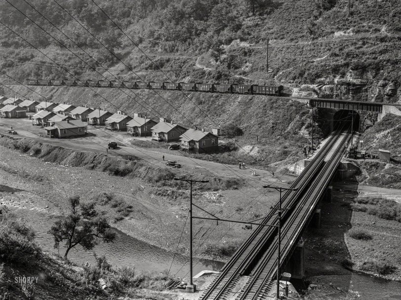
September 1938. "Coal mining community near Welch, West Virginia." Medium format negative by Marion Post Wolcott. View full size.
Hemphill
This picture is Hemphill Bottom near Welch, WV.
Bridge 894
He's right -- the bridge over the Tug Fork is at 37.4437N 81.5965W. It's bridge 894, as that marker says at the near end of the bridge. The current aerials show bridge piers that look a bit different, but it's got to be the one.
N&W was electrified Iaeger to Bluefield.
Shaft Bottom Road?
Did Kenorma mean Shaft Bottom Road rather than Mine Bottom Road? Unless I missed it, Google Maps doesn't show a Mine Bottom Road, but it does show Shaft Bottom Road NW of Welsh, WV.
N&W Electrification
The electrified line was part of Norfolk and Western's Elkhorn Grade electrification efforts on their Bluefield division, which was started in 1912 and subsequently decommissioned in 1950. At its fullest extent, 52 miles of the Bluefield division was electrified.
Found it.
At the intersection of River and Mine Bottom Roads northwest of Welch. The service track on the hillside is gone but you can still make out one of the abutments where it crossed over the main lines.
Electricity, but where?
I'm sure serious railroaders will weigh in, but I bet this line was electrified only through the tunnel. Lengthy tunnels and coal fired steam engines ain't a good combo. Has anyone pinned down the location of this image? Shouldn't be hard, what with the intersection of two rail lines, a road, and a rail bridge across the river. But I've chased all over Google maps without success.
Smokeless
It looks like the main line tracks were electrified. No coal burning engines in coal country!
One chimney on the houses
Single family dwellings makes life a little easier. Plus one outhouse apiece life of almost luxury in Welch.
Coal Miner's Daughter
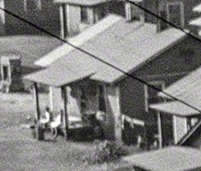
I found her and she's with a friend.
Yuck
River with who knows what coal runoff in it, no apparent city water, and an outhouse in the back of every house. Looks like a good business opportunity for the local doctor, if only they can pay.
Intrepid traveler
I have traveled the area covered by Ms. Wolcott in this series of photographs, and my experience has caused me to want to share this observation: Even with GPS, a modern automobile, readily available gas stations, well paved roads (and apps to warn when they’re not), etc., etc., traveling through this area can be quite an adventure. Then I imagine what it would have been like in the 1930s and I become quite impressed with this woman and her colleagues. I don’t think it’s too big of a stretch to suggest that what MPW did in the 1930s is more akin to the Lewis and Clark expedition than to what it would be to retrace her steps in 2019!









On Shorpy:
Today’s Top 5