


Framed or unframed, desk size to sofa size, printed by us in Arizona and Alabama since 2007. Explore now.
Shorpy is funded by you. Patreon contributors get an ad-free experience.
Learn more.


- I remember it well
- I can't prove it
- Complicated then, forgotten now
- Bryan-Stevenson
- Skinny is as skinny does
- How do you rest in peace
- Riding the footboards
- Alas, hidden from view
- Baldwin Diesels
- Exclusive pump
- Bananas, Oysters and Smokey Joe
- Details, Details
- What's that building to the left of the tower?
- Coal Barges
- Bromo-Seltzer
- Inner harbor
- The Basin
- What a headache!
- Giant stepladder?
- Yeah, it was cold
- Love those coats
- Link & Pin Days Remnant
- Baldwin 62303
- Baldwin VO-1000
- Cold
- No expense spared
- Tough Guys
- What's your hurry, where's your hat?
- Sheriff's Signature
- Relocated in the Eighties

Photos submitted by Shorpy members!
Print Emporium


Rainbo Is Good Bread: 1942

1942 or 1943. "Gilead, Ohio (?), possibly Mount Gilead" is the uncertain caption. Although the photo does provide a few clues. 35mm Kodachrome transparency by John Vachon for the Farm Security Administration. View full size.
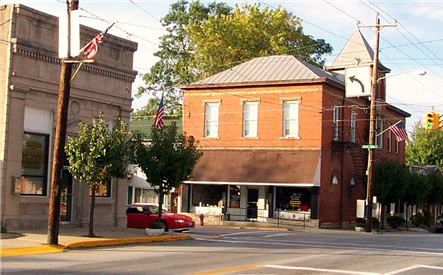
UPDATE: A couple of astute commenters have identified this as a building on Main Street in Mount Orab, Ohio. Google Street View gives a pretty good match. If there are any Shorpyite shutterbugs in Mount Orab, hie on over to the intersection of Main and High, send us some pics and help us lay to rest a mystery that's been bedeviling the Library of Congress for the past 65 years!
C.A. Long
C.A. Long was my great-grandfather. The building in the photo was constructed in 1896 for the International Order of Odd Fellows. The Lodge used the top story for its meetings and rented the ground floor. Charles Anderson Long (1859-1939) moved his grocery business from Williamsburg, Ohio, to Mount Orab in 1931.
The business before C.A. rented it in 1931 was a shop that assembled horse buggies (see second photo below). Charles rented the building for his grocery business. His son Julius Paul Long had taken over the grocery in 1939 after C.A.'s death. My father, J.P. Long Jr., bought the grocery in 1968 and continued the business on the corner of 74 & 68 until 1972, when it moved north of town on State Route 68. It closed in 1988.
The Marvel was the movie theater in town about one block south on Route 68. It is now being used as the local Masonic Lodge. Route 74 was renamed State Route 32 and then eventually Tri-County Road. The IOOF building was sold when the Lodge closed (1990s?) and is now being used as a women's clothing store.
Pictures-
C.A. Long calendar 1935
IOOF Building 1930
Long's Grocery 1968
C.A. and his wife Nellie Long


Grew up in Mount Orab
The Long family grocery store was indeed on the corner in question until the mid '70s, when it moved to a new supermarket-type store just up the road on US 68. I worked there in the late '70s. I don't know about C.A. Long. The patriarch of the family was J.P. "Sport" Long when I was there, and his son Paul ran the store.
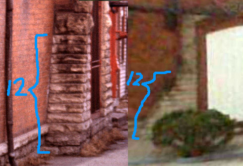
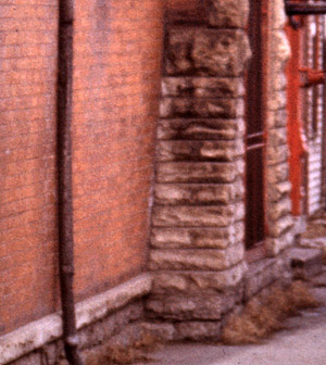
Stonework
If you "drive" by the side of the building on Google maps you can see that there is stonework in the same place as we see it in the picture. The fire escape is there too although the doorway has been boarded up.
[Yes, 12 rows in both the old and new photos. - Dave]
Question
All of this detective work makes me wonder if any of this information makes it back to the LOC. Do they ever update the photo information with the newfound information provided by this site?
[They do, for photos that are part of the Flickr Commons Project. Of which this is one. - Dave]
Cheers ATs
To the AT(s) that posted the current photo and street view - you along with this site are (and the rest who added clues) are poster children into the power of social networking (not the goofy mainstram media definition of it - but the real power) and worthy of an article in some prominent academic journal.
Plus...
...a gray hearse! We've only got black ones around these parts, so this is kinda exciting for me.
Route 74
Talk about ironies, I was just mentioning to someone at work about SR74 and its original routings today.
Route 74, according to the August 1929 Ohio Guide, passed through Cincinnati, Newtown, Batavia, Williamsburg, Mount Orab, Sardinia, Winchester, Seaman and Peebles.
Gone
All the beautiful woodwork has gone. That is a shame. "Modern" is not always better.
Wrong
Nope I think that you had this right the first time. I lived in Mount Gilead, and that is the corner that is right downtown. The porch has been removed but that is the location. Morrow County, Ohio. Sorry, and if you have traveled around Ohio any, you would know that every small town just about seemed to have the same layout. If you don't believe me go to Mount Vernon, Mount Gilead or Galion.
[The problem with your theory is that Route 74 never went through Mount Gilead. If you examine the details of the photos posted below (or travel to Mount Orab), you'll see that they are of building in our 1942 photo. - Dave]
Rainbo Bread
My dad had a small grocery store in western Kansas 50 years ago with a Rainbo Bread sign just like that one on the door. Brings back memories!
C.A. Lo__ Groceries & Hardware
My guess would be C.A. Long. Would the public library in Mount Orab have any local newspapers from the 1940s? An ad for this place would tie up that loose end. Also any ads for the Marvel Theatre or "Happyhour."
[A current photo of the stonework below, taken from the same angle, would also be helpful. - Dave]
Another view from Mount Orab
Update indeed
That "Update" is why you have to keep coming back! You never know what will be added or when!
Regnad Kcin worked here
Notice the sign on the door: "daerB dooG si obniaR"
A True Mystery
This picture is a true mystery. Ohio Route 74 was nowhere near Mount Gilead. It ran from Cincinnati southeast to Seamon and Peebles. That's about 140 miles south of Mount Gilead. If you want to read a really confusing history of Route 74, there's a Wikipedia page on it. Most of what's left of it today is known as Old State Route 32, renamed from SR 74 in 1962.The last SR 74 signs were taken down in 1963.
Or maybe not. In a period starting in 1938, the Columbia Parkway (Route 50) was built between downtown Cincinnati and Fairfax, and renamed SR 74.
Confused? Me, too.
Billy!
JUST WHERE DID YOU LEAVE YOUR NEW RED WAGON?
Rolling in dough
Peyton's Market in Moberly, Missouri, displayed the identical Rainbo slogan on the screen door in the early 1950s. The local radio station KNCM had call-in quiz shows, the winner being awarded seven loaves of Rainbo bread. As an elementary school student, I won the contest seven times. For a time, we had more bread than our family of five could eat!
Mount Orab
Route 74 went from near Cincinnati east about 50 miles to Peebles. It has since been rerouted and renamed Ohio Route 32, although you can still see a few "Old Route 74" sections on modern maps.
Route 74 passed through Mount Orab as Main Street, which is where this picture was taken.
The building pictured is still there.
Mount Orab, Ohio
A photographer who is going through multiple towns is going to have problems remembering where he took his picture. Fortunately, Wikipedia tells us that Ohio State 74 became Ohio State 32 in the early 60s. And using Google Street View in the town of Mount Orab (easy to confuse with Mount Gilead) brings us the above. Look at the side of the building in both pictures.
[Ding ding ding! I think we have a winner. - Dave]
Time warp
There are buildings that still exsist in Ohio that look the same as they did 40 or 50 years ago.
Rainbo is good bread...
and it looks like the onion sandwiches are very popular.
Rainbo bread
Thought Rainbo Bread decals might give a clue to location. Flicker has 61 photos labeled with this tag. This scene is the first in the list. Route 74 is an old sign that might be what is now Route 32. Southern Ohio in other words.
Route 74
Ohio Route 74 was renumbered 32 when Interstate 74 was built. It seems to be the same road as US50 in some places. A quick search shows a "Union Leader" newspaper in Toledo, a long way from Route 32 / US 50.
["Union Leader" was tobacco, not reading material. - Dave]
On Shorpy:
Today’s Top 5