

Framed or unframed, desk size to sofa size, printed by us in Arizona and Alabama since 2007. Explore now.
Shorpy is funded by you. Patreon contributors get an ad-free experience.
Learn more.

- Details, Details
- What's that building to the left of the tower?
- Coal Barges
- Bromo-Seltzer
- Inner harbor
- The Basin
- What a headache!
- Giant stepladder?
- Baldwin 62303
- Baldwin VO-1000
- Cold
- No expense spared
- Tough Guys
- Lost in Toyland
- And without gloves
- If I were a blindfolded time traveler
- Smoke Consumer Also Cooks
- Oh that stove!
- Possibly still there?
- What?!?
- $100 Reward
- Freeze Frame
- Texas Flyer wanted
- Just a Year Too Soon
- WWII -- Replacing men with women at the railroad crossing.
- Yes, Icing
- You kids drive me nuts!
- NOT An Easy Job
- I wonder
- Just add window boxes
Print Emporium
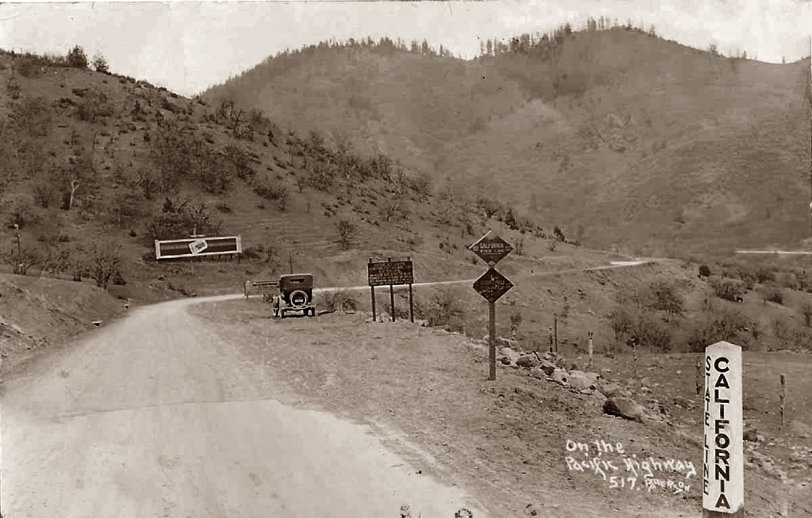
Pacific Highway
Another crossing
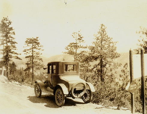
This is near the town of Hornbrook California. My father was traveling through this area in 1923 and his Model T burned out a clutch. He had the clutches replaced in Hornbrook. I am attaching a photo of where he crossed the state line and am not sure where it was. I know it must have been near here, or possibly down river near Happy Camp. He said he had to back up some hills in reverse to get to Hornbrook. The boarded-up garage was still there in 1970 when we drove through there.
Sign and Date
The sign to the right of the auto reads: "Visiting Motorists / the California State Automobile Assn. / Is At Your Service / Non-Resident Registration Certificates / Required by State Law. Tourist Map, General / Road Information and Digest of the State / Traffic Laws Supplied Without Charge."
I can only read the top line of the sign the auto is partly obscuring: "Non-Resident Motorists."
The earliest postmark I've found on this postcard is July 1926.
When the photo was taken the road was indeed gravel on the California side, but the Jackson County, Oregon segment had been paved for ten years. You can see the end of the pavement in the foreground.
Location
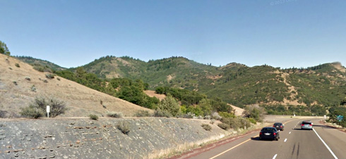
This may be the location where this photo was taken. It's on the Pacific Highway/Route 5 on the border of Oregon and California. The hills in the background look the same in both photos. The California/Oregon stateline sign is in approximately the same place as in the old photo. You can't see it in this new photo but it's on the right side, just out of the frame.
Pacific Highway
The old stage coach road is still visible as it crosses old Hwy 99 and I-5. This picture is probably that same road. I'll bet that sign next to the car tells you a list of things you aren't allowed to do or possess in California.
US 99
Looks to me like Jefferson Road, Old UD 99, that runs to the east of I-5 / SR 99.
Oops.
Pardon my conclusion jumping. Pacific Highway, it is, and that would make it Highway 99.
Don Hall
Yreka, CA
Re: Pacific Highway
Nobody said this was the Pacific Coast Highway. It's the Pacific Highway, a completely different route.
Please post a higher resolution image.
It's definitely not the Pacific Coast highway if it says Siskiyou County. Looks like it might be the border of old Highway 99, although the vegetation doesn't look quite right. Would love to see a higher resolution picture so I can check out the details.
Don Hall
Yreka, CA
Pacific Highway
Wikipedia article on the Pacific Highway.
Speaking of resolution, Kev, when you save your scans as jpegs you should choose "large file size" or "high image quality." Often this is shown as numerical scale from 1 (low quality) to 12 (high quality). All of your jpegs have a quality level of 3, which is why they are kind of fuzzy and pixelated.
pacific highway
It's not the pacific coast highway, anyway I don't think all the signs are readadle at the resolution that the photo is posted at but one of them says Siskiyou county.
Photo Location
If the photo was taken on the Pacific Highway would that not now be Highway 101 on the coast? I-5 is some distance inland. That would place the location about 4 0r 5 miles south of Brookings, Oregon








On Shorpy:
Today’s Top 5