


Framed or unframed, desk size to sofa size, printed by us in Arizona and Alabama since 2007. Explore now.
Shorpy is funded by you. Patreon contributors get an ad-free experience.
Learn more.

- Lofty addition
- In 1912
- Keenan Building
- Six years old
- Taken from the P.J. McArdle Roadway?
- It stood only 47 years
- Three track mind
- Incline to the right
- Reach for the sky, 1912 style
- No clean sweep
- Same Job Title, Same Face
- Sadly Lost
- Beautiful ...
- Where you get your kicks
- Aim High
- Pueblo Revival sisters
- Pueblo Neoclassicism
- Milk Man
- Regional dialect.
- Spielberg's inspiration
- Great Photo
- Loaf Story
- Do you still have the Rakes category?
- Could almost be a scene from the 1957 movie 'Hell Drivers'
- The Wages of Fear.
- Conspicuous by their absence
- Got Milk?
- All that aluminum
- No lefties
- Smoke 'em if you've got 'em
Print Emporium
Hyattsville: 1940
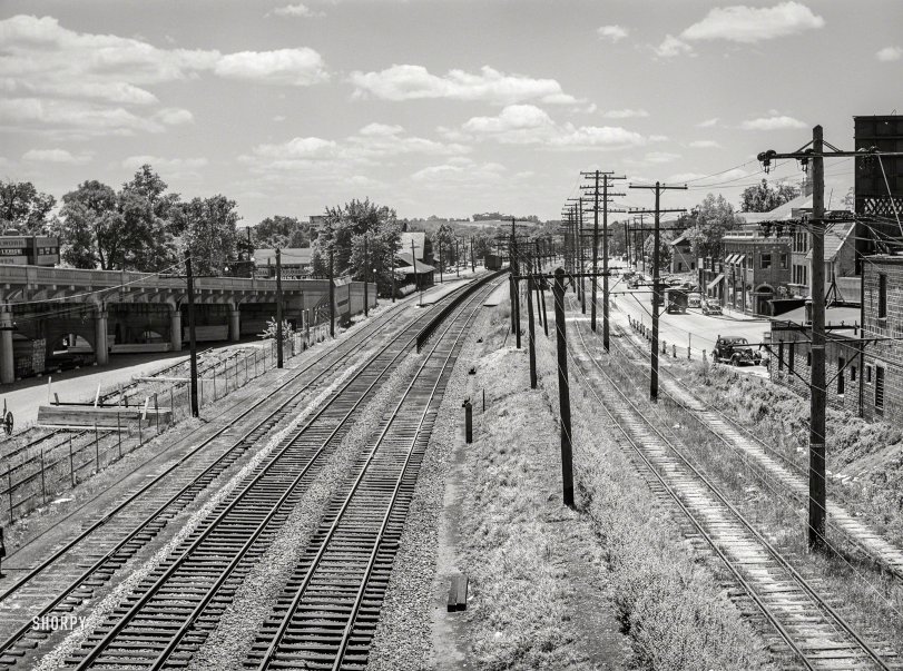
June 1940. "Railroad tracks along U.S. Route 1 at Hyattsville, Maryland." Acetate negative by Jack Delano for the Farm Security Administration. View full size.
Custard’s Past Stand
I lived no more three miles from Hyattsville in the 1940s and 1950s. It was famous for the Polar Bear frozen custard stand, which was a small chain in the DC area. It was the coolest looking stucco building with a statue of a polar bear out front. You can find it on Google Images.
I Stand Corrected
eugenegant - it appears you are correct. In my haste to ID the location, I failed to note the comparison of windows in the building I noted - they are different. The location of the road bend appears to correspond with your location as well.
US 1 and Farragut Street
Agree that we are looking south down Route 1, but believe that this is showing the intersection with Farragut Street, a block south of Gallatin Street. It would appear that many of these buildings have been demolished, leaving park space behind, but note the cupola and roof line of the current County Services Building in the background. Note also the stepped roof line of the building on the NW corner of the Farragut intersection, as that building still stands.
5100 Block of Baltimore Avenue
The view is looking south down Baltimore Avenue / Route 1 - the intersection on the right is Gallatin Street. The building on the corner still stands.
Old stomping grounds
I piloted more than a few trains through here, both freight and commuter.
Right to left we have U.S. Route 1 (Rhode Island Avenue), the main drag here, even today. The first two tracks to the right are the double track streetcar from Washington. They just came off of Rhode Island Avenue and are now on private right of way to Beltsville and Branchville. At one time they ran to Laurel. The line was cut back to Beltsville, but lasted to the end of DC trolley service (1961, I think).
The next two tracks to the left are the Baltimore & Ohio Washington Branch, opened in the 1830s. Note the fence between the tracks in the distance and the passenger platform for Hyattsville station, visible behind that clump of trees. The station here was a beautiful brick structure designed by E. Francis Baldwin; I don't know what happened to it, but in my time it had been replaced by an ugly utilitarian structure.
Hyattsville is passed by numerous commuter trains each day, but none have stopped here in many years. I suspect the total lack of parking has something to do with it.
Another main track, not visible here, swung behind the depot and turned south, connecting with a track from Baltimore to lead to the Alexandria Branch to Virginia. That branch today is a vital part of CSX's operations to the south.
The fifth track from the right is a station track. There are two more tracks to the left that appear to be freight sidings that were gone in my day.
I should mention that we are looking south (RR west) toward D.C.









On Shorpy:
Today’s Top 5