


Framed or unframed, desk size to sofa size, printed by us in Arizona and Alabama since 2007. Explore now.
Shorpy is funded by you. Patreon contributors get an ad-free experience.
Learn more.

- Lofty addition
- In 1912
- Keenan Building
- Six years old
- Taken from the P.J. McArdle Roadway?
- It stood only 47 years
- Three track mind
- Incline to the right
- Reach for the sky, 1912 style
- No clean sweep
- Same Job Title, Same Face
- Sadly Lost
- Beautiful ...
- Where you get your kicks
- Aim High
- Pueblo Revival sisters
- Pueblo Neoclassicism
- Milk Man
- Regional dialect.
- Spielberg's inspiration
- Great Photo
- Loaf Story
- Do you still have the Rakes category?
- Could almost be a scene from the 1957 movie 'Hell Drivers'
- The Wages of Fear.
- Conspicuous by their absence
- Got Milk?
- All that aluminum
- No lefties
- Smoke 'em if you've got 'em
Print Emporium
The Waste Land: 1939
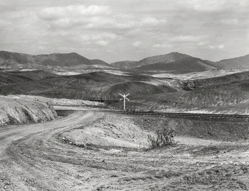
September 1939. "Ducktown, Tennessee. Fumes from smelting copper for sulfuric acid have destroyed all vegetation and eroded the land." Medium format acetate negative by Marion Post Wolcott for the Farm Security Administration. View full size.
East by Northeast
I believe the photographer's vantage point is just northeast of the intersection of Main Street and Hiwassee Street in Ducktown, the camera pointing east-northeast. If this is correct, the barren region pinpointed by our friend RGMBill in the Google image below corresponds to the lighter-valued patch of land seen in the photograph at 2 o'clock from the railroad crossing sign.
I searched through online historic map imagery to locate the snaking rail lines seen in the photograph. Upon discovery of a map showing rail lines that compare favorably with elements of the photograph, it did not take long to formulate my end-of-Main Street theory.
Today, it appears, Main Street ends at or just northeast of Hiwassee Street, but old maps show a road extending from Main Street across the railroad (as seen in the photograph), then down and out into the Ducktown hinterland.
Copperhill smelter
This is one time when Wikipedia really does summarize things well:
https://en.wikipedia.org/wiki/Burra_Burra_Mine_(Tennessee)
The mine itself is located below the marker in RGMBill's image, where there are a couple of small ponds. That's part of the mine's collapse. A larger collapse can be seen closer to the center of Ducktown. The mine buildings were located on the east end of town, the Ducktown Museum building being one of them (with a large mine collapse pond nearby). The name "Citiservices" is also associated with this mine on the map, if you're poking around.
About this picture, though: The smelter was located in Copperhill (formerly McCay), next to the Ocoee River, which is how ore was initially shipped out, and where train lines were built starting in the 1850s. The old smelter site is clearly visible from Google Maps or Earth.
Although copper mining began in the 1840s, the large-scale industrial smelting and sulfuric acid problems probably began in 1899. A good summary is here: https://web.archive.org/web/20120211230436/http://www.gamineral.org/copp...
I could not figure out where the image was taken, but the rail line followed the river north toward Ducktown, passing it on the west and continuing northward through Postelle, TN, skirting the foothills to its west. This would be about two miles west of the lake in RGMBill's image. I suspect the image was taken somewhere near Postelle.
The land is poisoned, but
Someone took great care to hand-letter that railroad crossing sign with the entirety of pre-automotive verbiage, complete with serifs.
Still appears to be almost a wasteland
The Verdant hills of Tennessee are marred by a scar in that area, and one of the areas close specifically calls out a tailings retention pond.
So I think this may be the place:
Sorry I'm having a problem embedding a Google Map; maybe Dave can figure out what I can't?
[Click "Share", click "Embed a Map." - Dave]









On Shorpy:
Today’s Top 5