

Framed or unframed, desk size to sofa size, printed by us in Arizona and Alabama since 2007. Explore now.
Shorpy is funded by you. Patreon contributors get an ad-free experience.
Learn more.

- Details, Details
- What's that building to the left of the tower?
- Coal Barges
- Bromo-Seltzer
- Inner harbor
- The Basin
- What a headache!
- Giant stepladder?
- Baldwin 62303
- Baldwin VO-1000
- Cold
- No expense spared
- Tough Guys
- Lost in Toyland
- And without gloves
- If I were a blindfolded time traveler
- Smoke Consumer Also Cooks
- Oh that stove!
- Possibly still there?
- What?!?
- $100 Reward
- Freeze Frame
- Texas Flyer wanted
- Just a Year Too Soon
- WWII -- Replacing men with women at the railroad crossing.
- Yes, Icing
- You kids drive me nuts!
- NOT An Easy Job
- I wonder
- Just add window boxes
Print Emporium
Blind Curve: 1941
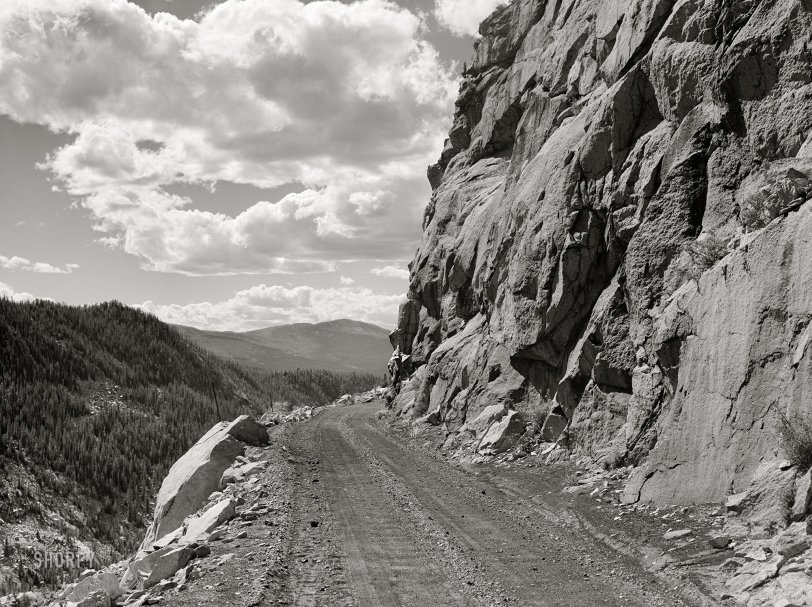
September 1941. "Road leading out of Carlton Tunnel along bed of old narrow gauge railroad on the west side of the Rocky Mountains from Leadville, Colorado." Medium format acetate negative by Marion Post Wolcott for the Farm Security Administration. View full size.
Leadville memory
I was in Leadville a few years ago and saw an old photo in an antique shop of a buggy with two local women in it going up a steep road with only a foot or so of dirt separating them from a fall to eternity. This reminded me of that and made me shiver all over again.
Lucy and Desi
may have made this drive in "The Long, Long Trailer."
Look where
This is one of those roads where my wife would be yelling "Look where you're driving, don't drive where you're looking" at me.
Hell Gate!
The Carlton Tunnel was formerly the Busk-Ivanhoe Tunnel of the late lamented Colorado Midland Railway, maintained for many years as a toll tunnel business by the last owner of the railroad, A.E Carlton, a Cripple Creek banker.
The tunnel itself would have been a couple of miles in the rear; this vista was known in railroad days as Hell Gate, although I have never seen what it looked like without rails. It was a very popular scene for advertising photos, and L.C. McClure and W.H. Jackson both photographed it. MPW must have been on her way to Aspen (still a mining town in those days). I never knew she passed this way. The river to the left is the Frying Pan.
You can still drive this route, although the Carlton Tunnel is sealed, and the road diverges from the railbed and crosses the divide via an adjacent saddle. The Busk-Ivanhoe Tunnel replaces a much higher bore, which is still open, and the roadbed up to the east portal is now a nice hiking trail.







On Shorpy:
Today’s Top 5