


Framed or unframed, desk size to sofa size, printed by us in Arizona and Alabama since 2007. Explore now.
Shorpy is funded by you. Patreon contributors get an ad-free experience.
Learn more.


- Baldwin 62303
- Baldwin VO-1000
- Cold
- No expense spared
- Tough Guys
- Lost in Toyland
- And without gloves
- If I were a blindfolded time traveler
- Smoke Consumer Also Cooks
- Oh that stove!
- Possibly still there?
- What?!?
- $100 Reward
- Freeze Frame
- Texas Flyer wanted
- Just a Year Too Soon
- WWII -- Replacing men with women at the railroad crossing.
- Yes, Icing
- You kids drive me nuts!
- NOT An Easy Job
- I wonder
- Just add window boxes
- Icing Platform?
- Indiana Harbor Belt abides
- Freezing haze
- Corrections (for those who care)
- C&NW at Nelson
- Fallen Flags
- A dangerous job made worse
- Water Stop

Photos submitted by Shorpy members!
Print Emporium


Lewiston Hill: 1941

July 1941. "Idaho wheat country -- extensive rolling fields. Lewiston Hill, north of Lewiston." Acetate negative by Russell Lee for the Farm Security Administration. View full size.
Good crop of houses
Here's another view, from the Lewiston Hill Overlook, that shows the ridge, with the river and bridge in the distance. Someone stuck a house on that ridge. It doesn't look like much wheat is cultivated here lately.
The Famous, or Infamous, Lewiston Grade
It's not quite so twisty these days. My mother went to nearish-by Washington State College (now University--go Cougs!) in the 1940s and she told me about a classmate, who was a pilot in the war, who wrecked his car going down the grade. He apparently got confused, thought he was in an airplane, and tried to bank the plane around a curve. When I asked how someone could get confused between a car and an airplane, she allowed as to how he might have been a bit tipsy.
The Southern Edge of the Palouse
A region that attracts photographers from all around the world. When I tell WSU and UI alum that, they look at me like I'm nuts.
Drove my '63 VW Beetle
in 1964 down this hill at night, I think I had to replace my brakes the next day, what a nightmare drive.
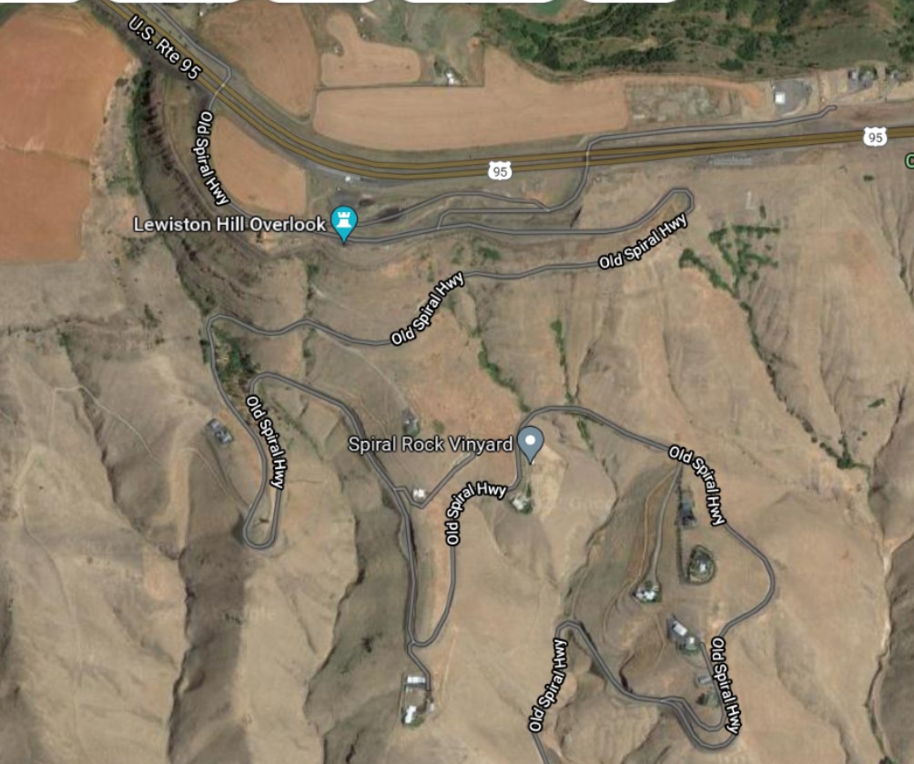
Old Spiral Highway indeed
No surprise that US Route 95 has replaced what is now called Old Spiral Highway. Here is what it looks like from above. Click to embiggen.
Google Street view from the old highway is grainy, so here is roughly the same angle as the 1941 photo but from US-95. You can see Old Spiral Highway between the guardrail posts.
Nice view from a motel
There is now a motel about where this photo was taken, above the appropriately named Old Spiral Highway. That's the Clearwater River in the distance, right before it joins the Snake River just out of frame to the right.
Lewiston is a twin city with Clarkston, Washington, on the other side of the Snake and which is home to the Lewis & Clark Discovery Center.
On Shorpy:
Today’s Top 5