


Framed or unframed, desk size to sofa size, printed by us in Arizona and Alabama since 2007. Explore now.
Shorpy is funded by you. Patreon contributors get an ad-free experience.
Learn more.


- Roll your own
- Rugged and real!
- A Charles Purcell - Mama Cass Connection
- Uncle SAAM
- Obfuscation
- One Chocolate Soldier rode away
- Victor Marquis de la Roche
- The Little House Across Way ...
- Vanderbilt Gates
- Vanderbilt Mansion
- You can still see that gate
- Withering heights for me
- So Jim,
- Top Heavy
- Re: Can't Place It.
- Bus ID
- Since you mention it
- The White Pages ?
- Moonlight Tower
- 1907?
- Fire(men) and Water
- Can't Place It
- Can anyone
- Wings
- Where's Claudette and Clark?
- Overbuilt Rolodex
- One song
- Give Me Wings Please!
- PRR
- Pinball Wizards

Photos submitted by Shorpy members!
Printporium


Kennett: 1942

July 1942. "U.S. Rural Electrification Services. Miscellaneous scenes in Dunklin County, Missouri. Kennett, seat of Dunklin County, at election time. Courthouse square." Acetate negative by Arthur Rothstein for the Office of War Information. View full size.
Better or worse?
After looking at Doug Floor Plan's post with how that portion of Kennett looks today, it got me to wondering if there are any small American towns that have improved their look since the 1930s/1940s. I would say that the Google Maps street view comes up short compared with the Shorpy photo every single time.
Stop 25-84
Intrigued by the "25-84" on the Stop sign, I did some searching. Missouri Routes 25 and 84 meet in Kennett, but not at the pictured intersection, unless Route 25 has changed between 1942 and now.
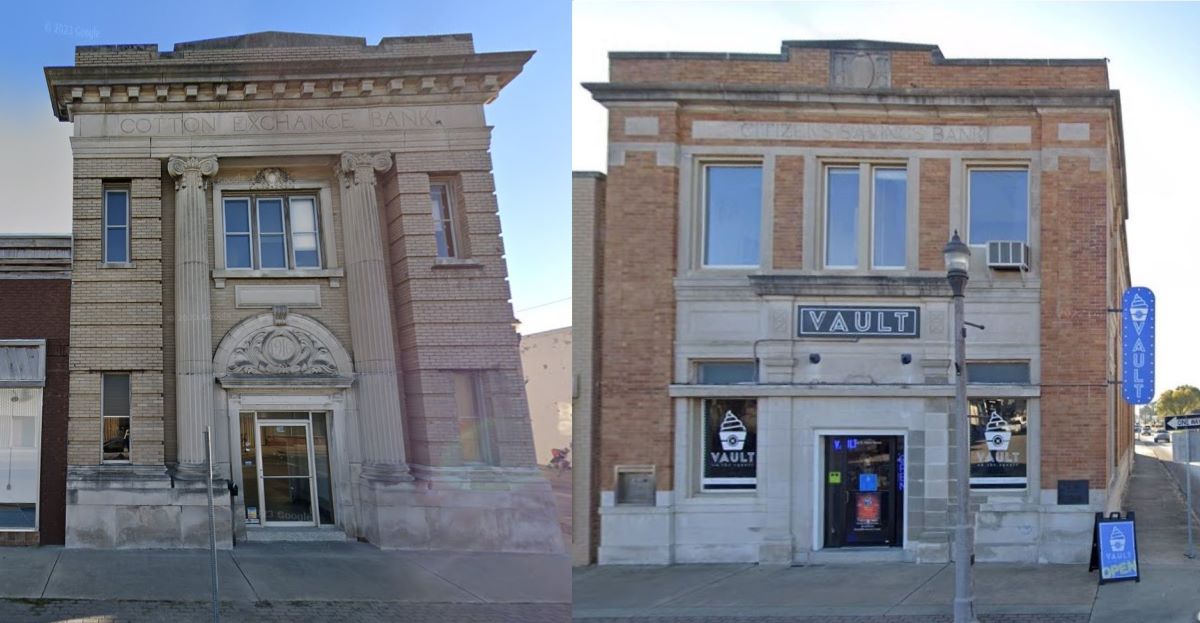
In Google Maps, this Shorpy image appears to be the intersection of east/west Missouri Route 84 (aka 1st Street) and offset College Avenue (along the Square) and Kennett Street (alongside the still-standing Cotton Exchange Bank building), both running north/south.
Missouri Route 25 (aka Independence Avenue) in Google maps runs north/south, and makes a T-intersection Missouri Route 84, approximately one mile east of the Square. There's a McDonalds conveniently locate at the T.
Can't make-out the writing on the Stop sign under "25-84", so not clear if Route 25 was relocated or renamed or what, in the intervening decades. Or maybe the sign says "in 1 mile".
Kennett Square has kept up its tradition of not providing street-name signs. None visible in the Shorpy image, and none visible in Google Maps (even with some swiveling around).
To kreriver's point, in the Shorpy image the Cotton Exchange Bank has a banner up top proclaiming "Remember Pearl Harbor" on what looks like a War Bonds effort.
Dueling banks
This is the best Street View I could get. If you move into the parking lot at right, the view loses clarity. The 1942 photo was, no doubt, taken from the second floor of the Dunklin County courthouse. Almost all retail on the square has been reduced to one story. However, the two-story Cotton Exchange Bank is extant (construction date in cartouche over door - 1916). Not sure what its current purpose is. If you travel to the right, to the next corner of the square, you'll see a remarkably similar two-story brick building, the old Citizens Savings Bank (date in cartouche in parapet - 1923), now an eating establishment. You can stand at the front door of one bank and clearly see the other. I'm sure the competition was fierce. I don't believe Citizens Savings had an outside clock (as did Cotton Exchange), but they did have a night deposit drop box and a metal marque over their front door. Did they also have a Remember Pearl Harbor banner atop their bank, or did they go one better?
The one degree of Shorpy
Kennett, home to none other than Higginbotham Family Dental

It really is a small world, isn't it ?
Mostly Intact
Courthouse square is mostly intact although most buildings have newer façades.
Watermelon capital
Home of the best Charleston Grey watermelons in the world!
Serious stuff
As of July 1942, declarations of war on America by Japan and Germany, Pearl Harbor, the Doolittle raid and battles of Coral Sea and Midway were recent history. There’s little doubt those events were the topic of at least some of the group conversations.
On Shorpy:
Today’s Top 5