


Framed or unframed, desk size to sofa size, printed by us in Arizona and Alabama since 2007. Explore now.
Shorpy is funded by you. Patreon contributors get an ad-free experience.
Learn more.

- Baldwin 62303
- Baldwin VO-1000
- Cold
- No expense spared
- Tough Guys
- Lost in Toyland
- And without gloves
- If I were a blindfolded time traveler
- Smoke Consumer Also Cooks
- Oh that stove!
- Possibly still there?
- What?!?
- $100 Reward
- Freeze Frame
- Texas Flyer wanted
- Just a Year Too Soon
- WWII -- Replacing men with women at the railroad crossing.
- Yes, Icing
- You kids drive me nuts!
- NOT An Easy Job
- I wonder
- Just add window boxes
- Icing Platform?
- Indiana Harbor Belt abides
- Freezing haze
- Corrections (for those who care)
- C&NW at Nelson
- Fallen Flags
- A dangerous job made worse
- Water Stop
Print Emporium
428 San Francisco Portland 275
![428 San Francisco Portland 275 U.S. 99 in Josephine County, Oregon. August 1939. Sign in service station window advertising for hop pickers three weeks before opening season. View full size. Photograph by Dorothea Lange. What city is this? [Answer: Grants Pass]](https://www.shorpy.com/files/images/8b34278u.preview.jpg)
U.S. 99 in Josephine County, Oregon. August 1939. Sign in service station window advertising for hop pickers three weeks before opening season. View full size. Photograph by Dorothea Lange. What city is this? [Answer: Grants Pass]
Grants Pass
This is Sixth Street looking down G Street. All the shops still have businesses in them. The structure on the right is not there anymore. That corner has a small building for the Grants Pass Chamber of Commerce.
Tarzan Movie Poster in Window
For those interested in such things:
Highways
It is Hwy 199 the connects Grants Pass with Crescent City California. I've driven it many times. The mileage is probably as near correct as any of the mileage signs in those days. The freeways shortened travel considerably. During WWII the highway over Mt. Sexton, just north of Grants Pass was rebuilt, almost to today's freeway standards because the army convoys couldn't handle the hairpin curves. I think the same thing happened to the Siskiyou pass. Prior to the freeway the highway passed through 32 towns between Portland and Medford using old 99E, a few less if you went 99W.
Prior to construction of 505 in California you had to go clear into Sacramento to get to San Francisco. I've driven all of these highways many times.
Lebanon and Corvallis
Lebanon is well east of old hwy 99E, almost to the foothills of the Cascades. Corvallis is on the west side of the Willamette valley on old hwy 99W
Grants Pass
Our son just emailed this link to me. The City Market in the picture was owned by my Grandfather. My Uncle that worked there is still living. He is an active 97 year old that refuses to grow old. If someone goes to the Wayside Inn at Alamo Lake, Arizona, he has many stories of the Grants Pass area, life in general, and a "few" biased opinions. I can still recall playing in the building during the early 1950's, while my Dad worked there.
Grants Pass
I should have read through the other comments before I started digging for info. :)
Another clue
... would be the sign that says GRANTS PASS BAKERY. Doy. (Not legible in the full size jpeg but I should have looked a little closer at the hi-res tiff.)
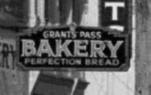
Definitely Grants Pass
The movie poster says "Rogue" and a quick Google search shows the Rogue Theatre is still a going concern in Grants Pass.
Chet Eide
For what it's worth, a death records search shows a Charles Eide born in 1920 and died 2001 in Lebanon, Oregon. Which is not far from the old Route 99. Up near Corvallis. Maybe the son of Chet?
I agree with the commenter
I agree with the commenter below. I can't read the lightpost base, but it's about 70 miles to Roseburg and 30 miles to Medford from Grants Pass, and I-5 was built along the old Highway 99 in that part of the state. The Portland distance is probably less right, since I-5 and 99 split north of Eugene.
The San Francisco route probably took the old HIghway 101 down the coast rather than 99, which would explain the extra mileage I didn't expect. The inland route ought to be 375-385 miles, not the 435 miles the sign says. Highway 135, which connects Grants Pass to Crescent City, would've been pretty new then.
Grants Pass
Bingo. It says BUILT BY GRANTS PASS IRON AND STEEL. Good work!
SFO-PDX
I believe in the Full-Size I can make out the words "City of Grants Pass" on the base of the street lamp. This would make sense as 99 (not a US highway anymore) passes through the city and the mileage makes sense.











On Shorpy:
Today’s Top 5