


Framed or unframed, desk size to sofa size, printed by us in Arizona and Alabama since 2007. Explore now.
Shorpy is funded by you. Patreon contributors get an ad-free experience.
Learn more.

- Details, Details
- What's that building to the left of the tower?
- Coal Barges
- Bromo-Seltzer
- Inner harbor
- The Basin
- What a headache!
- Giant stepladder?
- Baldwin 62303
- Baldwin VO-1000
- Cold
- No expense spared
- Tough Guys
- Lost in Toyland
- And without gloves
- If I were a blindfolded time traveler
- Smoke Consumer Also Cooks
- Oh that stove!
- Possibly still there?
- What?!?
- $100 Reward
- Freeze Frame
- Texas Flyer wanted
- Just a Year Too Soon
- WWII -- Replacing men with women at the railroad crossing.
- Yes, Icing
- You kids drive me nuts!
- NOT An Easy Job
- I wonder
- Just add window boxes
Print Emporium
Farmville: 1952
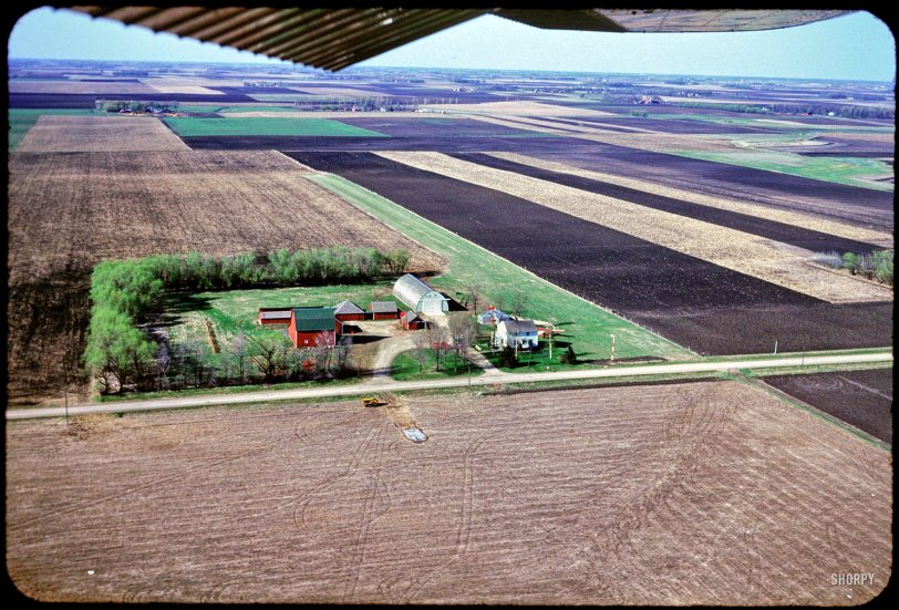
"Air view of Claude's farm -- April 27 1952." 35mm Kodachrome by Hubert Tuttle, traveling in Leslie's plane somewhere over Minnesota. View full size.
Leslie
Anyone have an idea of how Leslie came to be a pilot. Was he a pilot in WWII?
Minnesota DNR Landview
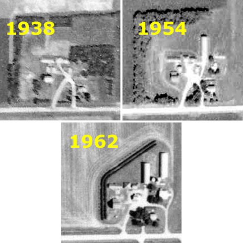
The Minnesota Dept. of Natural Resources and the U.S. Dept. of Agriculture shoot aerial photos of pretty much the whole state from time to time, going back in some cases to 1938. The farm is located about 2 miles south and 5 miles east of the city of Truman, Minnesota, on county road 148.
In 1938, the landing strip, T hanger, and metal building were not there yet.
In the photo taken in 1954, the T hanger and landing strip are plainly there.
By 1962 a second metal building had been added and the shelter trees had been torn up and new ones planted closer in to make more land available for farming. The air strip is gone.
The MNDNR site has a wealth of historic aerial photos of Minnesota and the immediate border areas.
The DeSoto is long gone
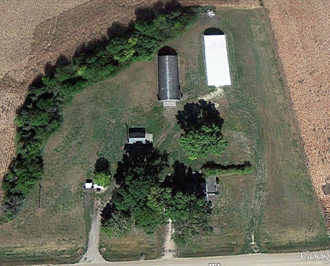
Using the clues provided by jsmakbkr I believe this is what's left of Claude's Farm. The driveway is the correct shape, the house and long metal building are still there but not much else. The runway strip is a slightly different color than the rest of the grass.
I was really hoping to see an old two tone green car up on blocks in the outback but no such luck.
Seasonal clues
It must be early spring because the willows are turning green and the remains of the snow pile are still melting in the field across the road. I'll bet the bulldozer makes a heck of a snow plow.
[Another clue is where it says "April 27" in the caption. -Dave]
Behind the House
I see a Tee-shaped building and was wondering what it could be. Then while looking though an aviation magazine from the late 1940s, I saw plans for a rural single-plane hangar. I enjoy it when several seemingly unrelated things come together to give a clearer picture of something.
W half of SW quadrant of Section 16
A 1940 plat map of Nashville Township in Martin County, Minnesota, shows the adjacent parcels then owned by A.C. (Claude) Boler, Hugh Boler, A.M. Boler, and Merrill Boler. Claude's 80-acre parcel with the farmstead and the airstrip is the western half of the southwest quadrant of section 16. Claude also owned the 40-acre parcel just across the road from his farmstead, in the immediate foreground (the northwest quadrant of the northwest quadrant of section 21). Google Earth shows that cost-effective farming has displaced most of the beauty of the farmstead. Some, but not all, of the old farmstead site is now cultivated, and there is a livestock containment facility across the road on the old south 40.
A Class Act!
Everything from this excellent Kodachrome batch was done with taste, class and simplicity. Even their plot of land!
The other airplane
The red airplane from the earlier image is also visible too. It appears to be still parked where it was in the other image.
It also looks like the green DeSoto car from the previous image is visible through the trees.
The Runway
I would assume the strip of green on the right is the airfield.
Corrugated iron.
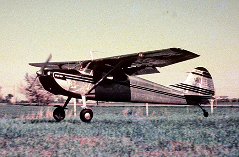
What is he flying? From the artifact in the top right it looks like a storage shed.
[Top right, or top left? Here's the plane. - Dave]
I think the DeSoto is making a cameo.
I'm seeing a pretty distinctive splotch of green behind those trees in the driveway.
[Yes, it's right where they left it in this photo. - Dave]

What A Shot
Dave, this was one of your better acquisitions. The quality of this group of Kodachromes just keep getting better.












On Shorpy:
Today’s Top 5