


Framed or unframed, desk size to sofa size, printed by us in Arizona and Alabama since 2007. Explore now.
Shorpy is funded by you. Patreon contributors get an ad-free experience.
Learn more.

- Lofty addition
- In 1912
- Keenan Building
- Six years old
- Taken from the P.J. McArdle Roadway?
- It stood only 47 years
- Three track mind
- Incline to the right
- Reach for the sky, 1912 style
- No clean sweep
- Same Job Title, Same Face
- Sadly Lost
- Beautiful ...
- Where you get your kicks
- Aim High
- Pueblo Revival sisters
- Pueblo Neoclassicism
- Milk Man
- Regional dialect.
- Spielberg's inspiration
- Great Photo
- Loaf Story
- Do you still have the Rakes category?
- Could almost be a scene from the 1957 movie 'Hell Drivers'
- The Wages of Fear.
- Conspicuous by their absence
- Got Milk?
- All that aluminum
- No lefties
- Smoke 'em if you've got 'em
Print Emporium
Up in Ohio: 1910
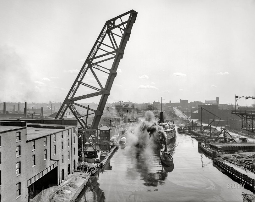
Cleveland circa 1910. "Superior Viaduct lift bridge and Cuyahoga River." Another bridge, another flour mill! 8x10 inch glass negative, Detroit Publishing Company. View full size.
On up the river a ways
For a diametrically opposed perspective of this rather oleaginous, riparian scene, reference 'Factoryville: 1910': https://www.shorpy.com/node/15037
(You may notice the Henkel's Flour sign in reverse.)
+110
So much going on!
Here is streetview of the same viewing angle, but you would need to be in the middle of the river straight ahead, and 100 feet up, standing on the now-gone east half of the Superior Viaduct:
https://www.google.com/maps/@41.4974805,-81.7013251,3a,75y,175.33h,90.65t/data=!3m6!1e1!3m4!1sLHH4ydcGMpLr0bHoYR914g!2e0!7i16384!8i8192
The end of the open Superior viaduct swing bridge is visible at the right edge of the old photo. Beyond the end of the swing span you can very faintly see the still extant stone arches of the west end of the viaduct thru the smoky haze. It looks like it doesn't line up, but it had a sharp kink to get onto the swing span.
The double track B+O rolling lift bridge was later replaced by the single track Strauss bascule bridge on the opposite side of the river, seen in streetview. The B+O line to their docks and the NYC connection has been abandoned for many years, but both lift bridges on the line are still there. In the distance of the old photo is the tapered Center Street swing bridge, still in use, and beyond that, the still active grain elevator, and the Erie RR coal dumper on the west side of the river.
The west half of the stone arch Superior viaduct is still there, as seen here from the old Center St. swing bridge, which still works, and is busy:
https://www.google.com/maps/@41.4942047,-81.7029803,3a,75y,336.85h,91.69t/data=!3m6!1e1!3m4!1sbrYKLhAsVvwj1A7mu96IBg!2e0!7i16384!8i8192
The steamboat's name is obscured by smoke, but the tug is Great Lakes Towing's brand-new in 1910 Dunkirk.
I spent a lot of time exploring the "Flats" in the early 1960's, when both the Erie and B+O lines were still in use.
[This might be a good time to learn how to embed a Google Street View! - Dave]









On Shorpy:
Today’s Top 5