


Framed or unframed, desk size to sofa size, printed by us in Arizona and Alabama since 2007. Explore now.
Shorpy is funded by you. Patreon contributors get an ad-free experience.
Learn more.

- Lofty addition
- In 1912
- Keenan Building
- Six years old
- Taken from the P.J. McArdle Roadway?
- It stood only 47 years
- Three track mind
- Incline to the right
- Reach for the sky, 1912 style
- No clean sweep
- Same Job Title, Same Face
- Sadly Lost
- Beautiful ...
- Where you get your kicks
- Aim High
- Pueblo Revival sisters
- Pueblo Neoclassicism
- Milk Man
- Regional dialect.
- Spielberg's inspiration
- Great Photo
- Loaf Story
- Do you still have the Rakes category?
- Could almost be a scene from the 1957 movie 'Hell Drivers'
- The Wages of Fear.
- Conspicuous by their absence
- Got Milk?
- All that aluminum
- No lefties
- Smoke 'em if you've got 'em
Print Emporium
Mississota: 1905
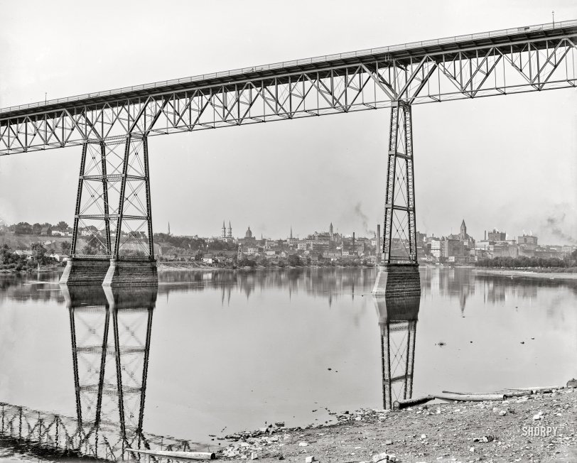
1905. "St. Paul and Mississippi River from under High Bridge." 8x10 inch dry plate glass negative, Detroit Photographic Company. View full size.
Actually
There are three horses shown in this photo. At least.
High Bridge Folly
I drove an empty school bus over that bridge in 1978. I was a 21 year old
student at the time and took the job because it paid $3.75 an hour as opposed
to the $2.10 I was making scrubbing pots in Coffman Union at the U of M.
I remember thinking 'Oh s--- this is the bridge that's crossed out in red on the wall map at the garage' as I entered it going from right to left in the photo. Fortunately
got over it without incident although those iron fences lining the road were no taller than chain link yard fences and not much stronger.
The weight restriction had gone into effect only a year or so earlier so until then trucks were using it, but still embarrassing.
Incidentally I've lived in St. Paul for 30 years, about 4 blocks from the left end of the bridge as pictured, and I've never heard the new bridge called anything but
the High Bridge. The Smith Avenue Bridge may well be its official name for all I
know, but no one around here calls it that.
Capitol comment
The dome is the former State Capitol, abandoned upon completion of the current one a few years after the pic was taken.
This photo reminds me a lot of the opening to Sinclair Lewis' novel 'Main Street': "On a hill by the Mississippi she saw the blinking windows of the skyscrapers in Minneapolis and St. Paul."
Dome is earlier iteration of state capitol
The dome is the second state capitol, built in 1883 after the first capitol burned. Current state capitol opened in 1905.
Dome ID
The domed building just right of the Church of the Assumption's twin spires is the second State Capitol building. This iteration of the State Capitol was completed in 1883, and demolished in 1937. It served as the capitol building only through 1905 (22 years), as the third State Capitol structure had been completed by then.
In fact, if you zoom in on the larger, left bridge pier--at treetop level--one can see a bit of the (then) new State Capitol's white dome. Having crossed the Smith Avenue Bridge (the eventual successor to the High Bridge) on more than one occasion, I knew the current Capitol dome had to be in this picture somewhere!
Dome in the middle
I think that dome in the middle was the 2nd state Capitol of Minnesota. 3rd & present one was finished in 1905. 2nd state Capitol on same grounds until it was torn down in 1937. Wikipedia has a photo of the 2nd which matches that dome.
Smith Avenue Bridge today
I'm pretty sure the twin towers belong to the Church of the Assumption and the square tower to the right is Landmark Center. Don't know what the dome in-between belonged to. If I'm correct -- here is the view today from atop the bridge:












On Shorpy:
Today’s Top 5