


Framed or unframed, desk size to sofa size, printed by us in Arizona and Alabama since 2007. Explore now.
Shorpy is funded by you. Patreon contributors get an ad-free experience.
Learn more.


- Baldwin 62303
- Baldwin VO-1000
- Cold
- No expense spared
- Tough Guys
- Lost in Toyland
- And without gloves
- If I were a blindfolded time traveler
- Smoke Consumer Also Cooks
- Oh that stove!
- Possibly still there?
- What?!?
- $100 Reward
- Freeze Frame
- Texas Flyer wanted
- Just a Year Too Soon
- WWII -- Replacing men with women at the railroad crossing.
- Yes, Icing
- You kids drive me nuts!
- NOT An Easy Job
- I wonder
- Just add window boxes
- Icing Platform?
- Indiana Harbor Belt abides
- Freezing haze
- Corrections (for those who care)
- C&NW at Nelson
- Fallen Flags
- A dangerous job made worse
- Water Stop

Photos submitted by Shorpy members!
Print Emporium


Far Hills: 1900

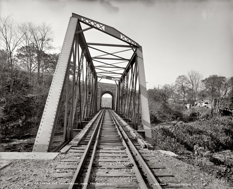
Far Hills, New Jersey, circa 1900. "Old country road." Probably not in Google Street View. (Update: How wrong I was!) Detroit Publishing Co. View full size.
WOW
I crossed that bridge many many times on the way to Bernards High. Used to live in Peapack. We all took the Erie Lackawanna train to school, ages ago. Wish to see a lot more pictures people. Bring them on. Thanks! Art
Far Hillsian
This is awesome! I live in Far Hills and take NJ transit into the city on that train line over that bridge. It is indeed the gatehouse to Natirar, soon to be Richard Branson's Virgin Spa, but through part of the leasing agreement, plain folks like us can walk around the grounds. The train trestle in the first picture is down behind the white house. It takes you over the Peapack brook which runs through Natirar. The tracks run under that dirt road and alongside the brook before terminating in Gladstone.
Supposedly during the Revolutionary War a tunnel was dug under this road and it's still supposed to be there. If I can find more on that I will post.
This is a really picturesque area and the train line (the old Erie Lackawanna) was used often in movies. Gladstone station doubles for Tuscumbia, Alabama, and Boston in the opening of the Patty Duke movie "Miracle Worker" (although they use a Black River train). Thank you for this!
Home Makeover
In the "Bird's Eye View" in Bing Maps, there is what appears to be a large dumpster behind the house. Perhaps some renovation work was ongoing at the time.
Definitely a raiload
I checked "10 Main Street, Far Hills NJ" on MapQuest and it clearly shows a railroad crossing the street a little southeast of the address. It really isn't very unusual for a rail line to be below the grade of another road (or house) in hilly country. And, as Dave from MN commented, you can definitely see the old truss bridge for the rail line, and possibly part of a signal post, just to the left of the bridge.
[You are maybe a little late to the party. The next post shows the rail crossing. - Dave]
Thanks Dave! LOL, I was a tad late and did see the photo of the trestle bridge after I had posted this.
Time of the year
I would also like to estimate the season (as Dave said, it cannot be around midsummer):
1. There are freshly fallen leaves on the ground, also on the road. It is Autumn.
2. In the photo sun shines from South-West. The shadows are in 35-40 degrees. Now I must estimate the angle at noon: It would be about 45-50 degrees, which is a bit less than the angle at the time of equinoxes (50 deg).
1 and 2: The photo is taken slightly after autumnal equinox (23.9.), let's say, 30th of September.
Sleuthing...
I just love hunting down some of these places!
I had just found it when I checked back and found I was right!
There are a number of historical markers, one just shy of the location (for the Peapack Brook Rural Industrial Historic District). The longitude and latitude brought me within a short distance of the spot.
http://www.hmdb.org/marker.asp?marker=18574
"The confluence of Peapack Brook and the North Branch of the Raritan River became a rural industrial center during the 18th century when a saw mill, grist mill, tannery and bark mill were located nearby. The Peapack Brook Rural Industrial Historic District includes five houses, several outbuildings and mill structures that reflect the industrial and agricultural development of the area, ca. 1750 - 1900."
Hot Day
I guess is it's quite a hot day in June or July. There's haze out in the field and they have a warmish look on their faces. The side window is open to get some air.
[Leaves on ground, bare branches, etc., do not say June or July. - Dave]
The well-dressed boy
Add me to those that think this is a fantastic photo. The multiple buggy tracks in the road drew me into it, but the child apart from the three girls caught my eye. Looks like a boy in a dress. I have a photo of my grandfather, born 1911, with long curls and wearing a dress. Couldn't believe that they dressed boys that way, but since have seen many photos of it. Strange custom. Anyway, great find!
Punto de vista.
Google hace las fotos desde un punto de vista bastante más alto (desde el techo de una furgoneta) aproximadamente a la altura de los antepechos de la planta primera, que aparecen en una línea casi horizontal.
En la imagen antigua el fotógrafo intencionadamente, para resaltar el barro del camino, quizás, puso la cámara mucho más baja, aproximadamente a la altura de los ojos de las niñas y, para captar las copas de los árboles, inclinó ligeramente la cámara hacia arriba.
Magnífico, gracias a todos.
Una cosa más, lo que se ve a la izquierda de las niñas ¿es una señal del ferrocarril?
Michael L found it
I grew up in Far Hills -- this is Main Street, which runs between Far Hills and Peapack.
Did we make her a Saint yet?
Beginning in 1908, Mrs. Ladd had provided a convalescent facility on the Natirar estate, originally at “Maple Cottage,” a large residence that once stood along Peapack Road where “deserving gentlewomen who are compelled to depend upon their own exertions for support shall be entertained, without charge, for periods of time while convalescing from illness, recuperating from impaired health, or otherwise in need of rest.”
Changed
Far Hills looks mighty hardscrabble in this photo, a far cry from the hoity-toity zip code it has developed into over the years.
The stone abutment
The truss bridge for the rail line has been replaced, but one of the stone abutments for the overpass is still there and looks as good as new. Quite a tribute to some long-gone stonemason. Wow wow wow!
Natirar gatehouse
I believe this is the gatehouse to the Natirar estate.
[Natirar -- "Raritan" spelled backward! - Dave]
Evocative
This strikes me as one of the most evocative photographs I have seen on Shorpy. It would take me the proverbial thousand words to explain why. They are spinning around in my head: about all the unseen creatures and things whose existence is so evident, including the world beyond the bridge.
Definitely a railroad
The raise in the road is tall for the time period. Also note the narrow, single track, truss bridge to the left. It is a rail line. Now for the New Jersey folks to ID it.
There's a muddy road ahead...
The hooves of draft animals and the wheels of the buggies or wagons they pulled have cut into the dirt road when it was wet. Looks like it's drying up a little now.
The house is only about a dozen feet off the road. I'll bet it caught a lot of road-dust when the weather was dry.
Stucco
The first thing I noticed was the stucco on the house. When the house was new, it must have looked really nice but it just seems kind of upscale for a country house which appears to be out in the middle of nowhere. Maybe Papa had something to do with the railroad?
Hey! There it is!
The hint that it is a railroad, not a stream, helped mightily. This seems to be the place:
[Kudos to Michael and the half-dozen others who managed to find this place. Color me impressed and amazed! - Dave]
I failed
I spent a few minutes trying to find this place in Google. Far Hills, New Jersey is a small burg, with few streets, most of which are covered in Street View. The apparent stone bridge in the background should narrow it down to just a few possible locations. Sadly, no success for this tipster, but hopefully someone more resourceful can take on the challenge and win.
Hills
The bridge doesn't look high enough for a RR, and anyway they'd just have a level grade crossing. There's no great traffic on the local line as it dead-ends a few miles north.
A better cue is the hill, probably, but I don't remember the topography well enough at a distance of 30 years. I used to bike through Far Hills every weekend as part of my regular century route.
Railroad Crossing
A couple of clues lead me to believe that the little stone bridge in the background goes over a railroad right of way. Any idea whose line it might have been?
[You just might be on the right "track." Stay tuned. - Dave]
Girl power
Looks like young ladies rule that roost. I would hate to be the little boy that had to tell them otherwise.

Nothing looks plumb in this photo...
but the trees.
Yes I know, trees are plum.
On Shorpy:
Today’s Top 5