

Framed or unframed, desk size to sofa size, printed by us in Arizona and Alabama since 2007. Explore now.
Shorpy is funded by you. Patreon contributors get an ad-free experience.
Learn more.

- Lofty addition
- In 1912
- Keenan Building
- Six years old
- Taken from the P.J. McArdle Roadway?
- It stood only 47 years
- Three track mind
- Incline to the right
- Reach for the sky, 1912 style
- No clean sweep
- Same Job Title, Same Face
- Sadly Lost
- Beautiful ...
- Where you get your kicks
- Aim High
- Pueblo Revival sisters
- Pueblo Neoclassicism
- Milk Man
- Regional dialect.
- Spielberg's inspiration
- Great Photo
- Loaf Story
- Do you still have the Rakes category?
- Could almost be a scene from the 1957 movie 'Hell Drivers'
- The Wages of Fear.
- Conspicuous by their absence
- Got Milk?
- All that aluminum
- No lefties
- Smoke 'em if you've got 'em
Print Emporium
Frisco Alfresco: 1906
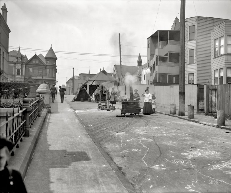
San Francisco, April 1906, after the earthquake and fire that leveled much of the city. "Cooking in the street." Detroit Publishing glass negative. View full size.
Living on the Edge
John Martini's identification of the photo to this block of Myrtle Street reveals just how narrow an escape these residents had. In this neighborhood, the fire was halted along Van Ness, which was the next street directly behind the photographer when he took this view. The red area in this detail of a 1907 San Francisco map shows the portion of the city that was destroyed by the fire. The small bright green rectangle indicates the location of this block of Myrtle Street, adjacent to the fire zone.
Mystery Box
I wonder what Charlie Chaplin is carrying up the street?
About street cooking
Kaboom
These people were afraid that cooking indoors with their coal or wood (or gas) stoves might ignite any gas leaking from broken supply lines. Which of course is why much of the city burned after the earthquake.
Am I Warm?
They're cooking in the street for a Cinco de Mayo festival.
Street cooking
Bonus question: Who can guess why, in a part of town where the buildings are still intact, people are cooking on the street?
Tiny Pirates
The lady swinging her fist is protecting the identity of the tiny pirate hiding behind her.
Re: Radical, dude!
Sure he will - right on top of the stove!!
Radical, dude!
That's a gnarly skateboard ramp man. You're never gonna land that one.
Myrtle Street
Took a bit of hunting but I found the location of this photo: Myrtle Street (or Alley) between Van Ness Avenue and Franklin Street. View is to the west, with the spire of the old First Unitarian Church just visible over the buildings at right. The Unitarian Church is still there but hidden from view. About the only survivor from the 1906 photo is the granite newel post.
La Marelle Ronde (Round Hopscotch)
Those "astrology charts" look very much like hopscotch spirals, similar to the French Escargot hopscotch -- La Marelle Ronde.
Snail hopscotch
The "horoscope" on the road is a version of Snail Hopscotch. Instead of a T shape, you draw a spiral, then start at the outside on 1, hopping toward the centre, switch feet and hop out.
Played it endlessly as a kid, amongst other schoolyard games.
Virgo rising
Looks like someone drew an astrology chart on the pavement.
On the level
Evidently there's more of a hill on this street than meets the eye, judging by how the back legs of each kitchen range are shimmed.
Post no bills
Nor Freds or Jims or Kens either.










On Shorpy:
Today’s Top 5