MAY CONTAIN NUTS
HOME

Search Shorpy

SEARCH TIP: Click the tags above a photo to find more of same:
Mandatory field.

Search results -- 30 results per page


Erie Canal: 1904
"1904. Erie Canal at Salina Street, Syracuse, New York." Detroit Publishing Company glass ... always tell your pal, If you've ever navigated On the Erie Canal. -- "Low Bridge" by Thomas S. Allen Clinton Square ... 
 
Posted by Dave - 08/01/2012 - 1:34pm -

"1904. Erie Canal at Salina Street, Syracuse, New York." Detroit Publishing Company glass negative, Library of Congress. View full size.
Watch Yer HeadLow bridge, everybody down.
For it's low bridge,
We're coming to a town!
You can always tell your neighbor,
You can always tell your pal,
If you've ever navigated
On the Erie Canal.
-- "Low Bridge" by Thomas S. Allen
Clinton SquareLooks like this is now a large public fountain if, as it appears, this current shot is taken from almost the exact same angle. 
http://www.panoramio.com/photo/12595565
(Click the photo for Shorpyesque "Hi-Def Image")
Stone GorgeousAll the elaborate stonework of the buildings along the canal makes the scene look something like Venice. Was that intentional, or not? I'd say that it was.
I once spent a summer in Venice,
And I had a yen to play tennis,
But those darn canals were a menace,
So I didn't play tennis in Venice.
-- Frank Crumit (1931)
Horse PowerIn 1904 I would have expected real horse or mule power to pull the barges but it appears there is no path on one side and, to the left, it stops.  Is this a terminus or are they perhaps using coal?  
Stairway to HeavenLove the stairs to nowhere. But wait! Not to nowhere. The stairs become very valuable when the bridge is up. While up, canal boats can pass underneath and pedestrians can use the stairs to cross without having to wait for the bridge to come back down. I've never seen a bridge like that. 
Path to somewhereI live in Syracuse, the path on the left stops in Albany.  They do have some steamers in this shot though.  Behind the photographer, the canal split, the Erie to Buffalo, the Oswego Canal to, well, Oswego a port city on Lake Ontario.  This scene lasted only 12 more years until the Barge Canal opened. Then the Erie thru Syracuse was filled in (with garbage)and became Erie Boulevard, one of Syracuse's main thoroughfares .
The grassy knoll was replaced by the Soldiers and Sailors monument and the City of Syracuse recently place park at this same spot.

Clinton SquareThe old Erie Canal as it ran through downtown Syracuse has been paved over (now Erie Boulevard). There is a small pond-like area in the view you see, also used for winter ice-skating and outside concerts when drained. In the Shorpy view to the left and right of the canal were unloading docks and an outdoor market. To the right is the beautiful old Onondaga Bank Building, in the middle the Gridley Building and to the left the old Syracuse Savings Bank. All of these buildings remain and form what is today known as Clinton Square.
Syracuse Savings Bank"Main Street, U.S.A." notes that the 1876 Syracuse Savings Bank on the left is a steel-framed "textbook example" of High Victorian Gothic designed by Joseph Lyman Silsbee. A graduate of the first American school of architecture (the Massachusetts Institute of Technology), Silsbee is noted as mentor to to a generation of architects including Frank Lloyd Wright.
Steam PowerBy 1904 they were probably using steam-powered barges on the Erie, as they were doing then on the canals here in Illinois.
[News clips mention Erie barges being moved by tugboats -- electric and steam-powered. - Dave]
Beautiful city and canal.I do like this area of New York. The money used to build the Erie Canal was well spent and then some. 
Erie CanalI have lived in Syracuse since 1933.  Although the Erie Canal as it went through the center of Syracuse has been filled in, the essence of the canal remains.  The circa 1845 Weigh Lock Building two blocks East of the photograph is a museum, and many of the engineering marvels of the Erie Canal still remain as mini parks and hiking trails along the towpaths, like the "water over water over water" display in the park on Butternut Drive in DeWitt. The citizens in the communities all along  of the Erie Canal have done a great job preserving it and encouraging tourism.
The 'Ear-I-Ee' CanalWell, someone had to say it!
(The Gallery, Boats & Bridges, DPC, Syracuse)

Erie Canal: 1910
Utica, New York, circa 1910. "Erie Canal at Utica." 8x10 inch dry plate glass negative, Detroit Publishing ... of where it intersects with Broad. The route of the old Erie through Utica was filled in and is now Oriskany St. That's ... 
 
Posted by Dave - 09/29/2012 - 10:20am -
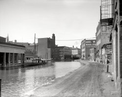
Utica, New York, circa 1910. "Erie Canal at Utica." 8x10 inch dry plate glass negative, Detroit Publishing Company. View full size.
Possible location..The George W.Head Flour, Grain, Feed (on the right in the photo) is listed on a 1906 billhead as being at the corner of Broad and John streets.  I can't seem to find any buildings today that appear in the photo minus the possible spire of the St. Johns Catholic church which sits 2 to the 3 blocks south on John st.  
Great photo.
George M. Cohans The Honeymooners.It was a 1907 Play so the sign is a few years old.
Starring George, Jerry and Nellie Cohan, it ran for 72 Performances.
Source: Musicals101.com 
LocationThe trolley is crossing the John St. bridge, so the spire is Grace Episcopal a bit south of the canal.  St. John's, which has twin spires,  would be out of the photo at left, since, it too is on John St., south of where it intersects with Broad.   The route of the old Erie through Utica was filled in and is now Oriskany St.  
That's pretty coolDoes any of that survive? Did the canal go through the heart of Utica? I live outside Boston and you can still see the remnants of the old Middlesex Canal. Sad though, as the suburbs fill up more and more of it has been lost to history. 
Could that be...the remains of the Squire Whipple designed Utica weigh lock on the left, which hadn't been used since tolls were abolished on the canal in 1882, after the construction bonds/loans had been paid off? Those were the days!
weighlockThe building on the left is a weighlock. I don't think it still exists in Utica (or at least I didn't see it the last time I was there). But the one in Syracuse is still standing, and has been turned into the Erie Canal Museum. Picture from the museum's website below.
What about now?I would love for some Utica NY Shorpy expert to figure out what this shot looks like now,if it even exists.  The Erie canal was the most financially successful canal venture ever built in this country. First proposed over 100 years before it actually opened, and taking nearly 20 years to build at a staggering cost both financially and politically for those that opposed and supported it.
The Erie canal forever changed the makeup of this nation in terms of east to west migration and allowed the "middle" to reach the east coast and ultimately Europe with both agricultural and manufactured goods and also allowed the vast manufacturing of the East to move West, cheaply. Ohio, Indiana, Michigan, Illinois and many other states went from wilderness frontiers to viable economies because of this canal.
The Railroads rendered almost every canal in the nation useless overnight. The Erie, while greatly diminished in tonnage after 1850 remained very important to New York, and the Eastern Great Lakes Region almost into the 20th century.
Oriskany StreetAbout the time this photo was taken the New York State Barge Canal was being built to handle larger barges.  In some places the Erie Canal was simply widened, but in cities like Utica, Syracuse and Rochester a new canal was built.  In Utica, the new canal was about a half-mile north of the Erie Canal.  
This map shows the Weigh Lock.  It is where Oriskany St. turns into the East-West Arterial Highway at the intersection of Broad St.  None of the buildings in the photo are still there. 
Mr. Rogers Was HereLooks like an open-sided trolley or street car is on the cusp of crossing the bridge from left to right (gauging by the angle of the trolley pole), while a couple of men-folk are crossing on the bridge's pedestrian walkway. A bucolic urban scene for yesteryear. Lovely shot. Thanks for posting it.
Singing "Erie Canal"I was in the 4th grade in 1950 in Cincinnati and our music teacher always had us sing "Erie Canal".  I still know the words as that song always stuck with me:
I got a mule her name is Sal,
Fifteen miles on the Erie Canal,
She's a good old worker and a good old pal,
Fifteen miles on the Erie Canal.
We've hauled some barges in our day,
full of lumber, coal and hay,
and we know every inch of the way,
15 miles on the Erie Canal.....
Low bridge, everybody down;
Low bridge 'cause we're comin' to a town.
And you'll always know your neighbor,
You'll always know your pal; if you ever navigated on the Erie Canal.
SUCH SWEET MEMORIES!
LocationTo set the record straight, the street in the background is Genesee Street. The vantage point appears to be from the John St. bridge. The canal is now Oriskany St. By the time this photo was taken, the State had stopped collecting canal tolls, so the building had no use aside from office space. You can see by the broken windows that this building appears to be empty. There were once five of these weighlocks, the only one left is in Syracuse. The State DOT, which had control of the canals up to the 1990's used the Syracuse building as office space until the late 1950's or early 1960's. It was then purchased by the city of Syracuse and turned into a museum.
(The Gallery, Boats & Bridges, DPC, Utica)

Syracuse Panorama: 1901
... Syracuse, New York, circa 1901, in a panoramic view of the Erie Canal combining three 8x10 inch glass plates. Detroit Publishing Company. ... 
 
Posted by Dave - 07/28/2012 - 4:16pm -

Syracuse, New York, circa 1901, in a panoramic view of the Erie Canal combining three 8x10 inch glass plates. Detroit Publishing Company. View full size.
Jerry Rescue BlockThe building dead center (left of the lift bridge) is the Jerry Rescue Block.
Wrote my Masters Thesis on the Rescue, too much to share, but the wiki entry is a decent if incomplete thumbnail:
http://en.wikipedia.org/wiki/Jerry_Rescue
Onondaga Coarse Salt AssociationWikipedia has a wealth of interesting detail on the Syracuse salt industry in general, and mentions the OCSA headquartered at No. 1 Clinton Block - 'Manufacturers and Dealers in all kinds of Coarse or Solar Salt." (Mid-frame, on the immediate right of the canal).
Today in SyracuseView Larger Map
The post office at the center is where the "Clinton Block" on the right side of the picture once stood. The canal itself has been filled in long ago and is now Erie Boulevard, which runs along the left side of the post office.
Gone but not forgotten All of these buildings are long gone. The one on the left with the tower and long shed is the old New York Central station.
The pre-concrete Erie CanalFor those not familiar with this area, the waterway with the bridge over it is the Erie Canal as it passed through downtown Syracuse (before it was paved over). You're looking essentially West. The bottom of the photo not seen is now "Clinton Square" (named for Dewitt, not Bill) where several majestic old buildings still survive. See https://www.shorpy.com/node/5501
Bridge explanation?That bridge across the canal has me puzzled.  Did it raise with some sort of mechanism to the position seen in the photo, for passage of boats?  It looks like there's nothing to keep a person from falling off the ends of the nearest walkway (can't tell about the one on the other side).  
At least one  building is still there. Center of the picture to left of canal. The first building is gone (with white walls) but the middle building still stands.
View Larger Map
Lift bridge sidewalksThe far side of the lift bridge has stairs that connect to the sidewalk on that side when the bridge is in the up position. The gents apparently decided to take a ride on the side that has no up connection, which although frowned on, is still considered fun by some. Several bridges of this type have survived to this day on the Erie Canal:
http://bridgehunter.com/ny/orleans/knowlesville-road/
http://bridgehunter.com/ny/monroe/washington-street/
http://bridgehunter.com/ny/niagara/adam-street/
Canals are so coolI think they should dig up the Erie Canal and open it to traffic again.  Traveling around England and Europe on the canals is a fantastic way to see the countryside.
A world of bikes at the end of the golden age of bikingIn the lower right hand corner, you can see what looks like a bike rack on the sidewalk.  Of course the 1890s had been the golden age of bikes, and the Model T was still 8 years away from sale to the public.  The world of the car was about to emerge, but not yet, not in 1901.   When it did, sidewalk bike racks probably wouldn't come back for, oh, about 100 years, until about yesterday afternoon.
Throughout the image I count 7 bikes, 2 with riders, 5 parked, although there may be more than 2 under the awnings of the bike store.  And of course there is a bike store in the middle, on a prominent commercial corner, because bikes were still a bigger deal than they were about to become as auto production began to double every few years of the early 20th century.
Peeking LiftThere's another lift bridge peeking out one street west ("up picture"). It is just barely visible on the north (far) side of the canal, in the up position. Look somewhat below the "Greenways" sign for it.
A bridge in actionHere is a video of the same type of bridge in action. This bridge is located in Brockport, NY.

Summer TrolleyThere's a very unusual double deck entirely open summer trolley car on the dead end tracks on Clinton St. that don't connect with the main tracks on Genesee St., lower right of the photo.
Is the "one on the left with the tower and long shed" actually the New York, West Shore & Buffalo depot?  Back then, New York Central passenger trains ran in the street downtown.  Technically, both lines were under common ownership.
Wish grantedThis photograph almost fulfills my wish to have lived in that great era just to feel, smell, and see our great city. I've been trying to piece together how the railroads ran through the city and this answers so many questions. Absolutely beautiful!
(Panoramas, Boats & Bridges, DPC, Railroads, Syracuse)

Barge Wife: 1941
... October 1941. "This barge wife is painting up the ship. Erie Canal, New York." Medium-format nitrate negative by John Collier. View full ... 
 
Posted by Dave - 11/01/2012 - 2:40pm -
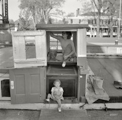
October 1941. "This barge wife is painting up the ship. Erie Canal, New York." Medium-format nitrate negative by John Collier. View full size.
Guy Park in Amsterdam NYThis looks to be Guy Park Manor in Amsterdam NY.  I spent a lot of time there when my children were little. Tropical storm Irene about destroyed the place.
Adjustable?It appears that the second story is designed to slide on the first floor.  Not only is the visible wall somewhat keyed, the door is also dutched.  I would think this can't be the only access to a cargo hold or below deck.
The Old Erie CanalThere's a great old movie called "The Farmer Takes a Wife", from 1935, (Henry Fonda's first film) that depicts Erie Canal life in its earliest days.  Looks like thing changed very little in one hundred years, other that clothing styles.  The house in the background is a very classic example of Greek Revival architecture, typical of the Erie Canal era.
(The Gallery, Boats & Bridges, John Collier, Kids)

Syracuse Bids You Welcome: 1904
... Holy Schnikes! What a fortress! On the Erie Canal City Hall was built about 50 yards off the old Erie Canal, which ran ... 
 
Posted by Dave - 07/29/2012 - 10:08am -
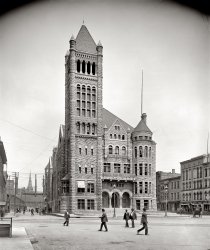
Circa 1904. "City Hall, Syracuse, New York." An electric welcome to the Salt City. 8x10 inch dry plate glass negative, Detroit Publishing Company. View full size.
Paint jobIt looks like they also painted over the original natural stone; not an improvement but at least the building is still standing.
And TodayThe electric sign is gone. But they've added color!

Not painted.  Just cleaned.The old photo shows stone as it looked when the air was full of coal dust, which turned facades dark after a few years. These days the stone can be cleaned and it stays pretty bright for years.
Blue skyThank you for the latter-day picture. That's the first thing I look for in the comments accompanying old images of landmark buildings.
Revival SurvivalThis Romanesque Revival gem has survived surprisingly intact in spite of the fact that the surrounding buildings from 1904 have all been destroyed (as seen on Google Street View).  It appears that the turrets on the main tower (and those flanking the center gable) have had their tiny conical roofs lopped off, and that in addition to the electric sign, the only other major losses are the rooftop flagpole and patch of lawn in front (after all of the awnings this week I'll not shed a tear over their absence).  Even the varnished wooden doors are the same. Amazing!  It's great to see something this eccentric come down through time retaining its integrity!
Holy Schnikes!What a fortress!
On the Erie CanalCity Hall was built about 50 yards off the old Erie Canal,  which ran through downtown Syracuse until it was covered over in 1925 by Erie Boulevard. You can see the City Hall turret tower on the right side of this old postcard featuring the "Weighlock" building on the Erie Canal (which also remains now as a Canal museum).

Also a great picture taken from the Canal side: 
Hello CentralOne of the reasons Syracuse bid you welcome was that the the New York Central main passenger line passed right in front of this building until 1936. The speed limit was 15 mph. All of the Central's mightiest trains got this welcome.
(The Gallery, DPC, Syracuse)

Unloading: 1900
... Terminal Facilities for Ore and Coal Traffic on Lake Erie. Buffalo, N.Y. Delaware, Lackawanna & Western ... Look at all of those barges waiting to go back up the Erie Canal. Steam or electric? I'd say steam from the steam plant on the ... 
 
Posted by Dave - 08/08/2012 - 7:36pm -
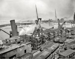
Buffalo, New York, circa 1900. "Thornberger hoist unloading ore at Lackawanna docks." 8x10 inch glass negative, Detroit Publishing Company. View full size.
 18440I hope those 2 guys standing in that open boxcar were getting hazardous duty pay.
Janey Couplers & BrakesIt is interesting to note that all the freight cars (drop bottom gondola type) are equipped with Janey style knuckle couplers.  Car 18440 is marked as having air brakes but the others are not and do not show any air hoses next to the couplers.  These cars must have been assembled into very interesting trains with air brakes on some cars and hand brakes on others.  This picture was taken during that transition time.  I think air brakes were required by law on all interchange cars (those cars passed from one railroad to another) by 1906.
Flat bottom gondolasI never thought about how the unloaded those cars -- hole in the middle, so men have to push the coal to the opening, eh? I had wondered. Labor was all American back then.
The American Flyer train set I had as a kid had cars that tilted to dump.
That's a load?Note the gondolas with a pile of ore in each end of the car. These cars are loaded. Ore is much heavier, by volume, than coal. To load one of these cars with ore like the coal load in the foreground, would cause the car to collapse. Coal hoppers are loaded with iron ore exactly the same way today.
Also note the old boxcar sitting on the ground at right. It has been demoted to yard shanty status. This car is about 34 feet long, and was likely built in the 1880's.
Six-Rig Thornburg HoistI believe the correct spelling is Thornburg, though their are several variants: Thornberg, Thornburgh, and Thornberger. A reverse view of the same machines is at Hydra: 1901. An earlier year of the Blue Book referred to them as   Excelsior Hoists. I can't find out much information on either Thornburg or Excelsior Hoists and whether they were one and the same. Also, I still can't figure out how these things were powered: electric or steam?  


Blue Book of American Shipping, 1909.

Railway Terminal Facilities for Ore and Coal Traffic on Lake Erie.


Buffalo, N.Y.


Delaware, Lackawanna & Western Railroad Co., (Docks in Erie Basin), W. E. Dowle, assistant general freight agent — Six-rig Thornburg hoist, capable of unloading 1,500 gross tons in ten hours. All rigs can be worked on any vessel having hatches of 24 feet centers or less. No storage room.
Medieval ore loadersLooks like a bunch of trebuchets to me.  Look at all of those barges waiting to go back up the Erie Canal.
Steam or electric?I'd say steam from the steam plant on the left. the venting out the top is a tell tale of steam pressure venting from an engine.  I imagine the steam is produced there and vented there (no venting on the rig itself it seems) and supplied under the track it traverses on. I just wonder if they had some kind of flexible piping to allow the thing to move or if they hooked it up after setting it in place.. it doesn't look like it has to travel far.
One more possibility is that they were powered hydrolically from the steam plant. that would solve a lot of problems bringing steam out to the units. the other post mentions 2000t over 10 hours so I don't imagine each of the units had to deal with a lot or weight in a shovel full. I think it was built for speed over capacity and hydrolic would make sense and is about right for it to be tried in 1900 for a job like this
Electric or steamThe building in the foreground with the large stack and the 2 smaller stacks appears to be a stationary steam plant. I do not see any wires or typical electric infrastructure going to the hoists. On the other hand I also do not see any evidence of steam operation on the hoist mechanism. If they were in operation at the time of the photo you would see exhaust steam coming off of the steam powered winches. 
A Powerful IdeaThe power to these hoists perhaps is provided by a line shaft from the shed on the left, which happens to be inline with the hoists.  There appear to be two steam exhaust stacks from the roof, which could indicate a large twin cylinder or tandem steam engine with a boiler elsewhere.  A line shaft could exit the end of the shed and run through near the base of each hoist much like an old time machine shop providing power to each hoist, and each of course being individually controlled by an operator.  Also note, the counter balance weights on each hoist that look like lumber planks stacked three or four, hooked to cable running over pulleys and guided by round bar.  I think rather than wood planks, they are large steel flat bar counterweights to assist in moving and/or balancing the load of the booms as they swing back and forth.  A second set of weights are certainly on the other side of each hoist out of view.  A line shaft providing power to the cable lifts for the ore buckets and also the booms, which being relieved by the counter weights would require less power.
ShaftsOn the link kindly provided by stanton_square showing the other end of these hoists, one can see a shaft extending from the last hoist and being supported by a sawhorse and a bearing block being positioned by tapered wedges or shims.  Such a block, probably wooden, properly oiled provides a surprisingly good bearing surface and placed to keep the shaft from whipping and damaging the inboard bearing.  This shaft extension leads me to believe that indeed this set of hoists is powered by a line shaft from the shed.  All of the hoists probably have these shaft extensions for connection to each other and rather than cut off the last one, it is usually left in place for future expansion or to move to another position should one hoist be destroyed or go out of service.
Other unloading cranes Here's a link to the development and photos of much larger buckets and cranes as the industry evolved. Visit each of the sites in the left navigation page for a overall history.
Unloading Iron ore
http://www.clevelandmemory.org/glihc/oretrade.html 
Alva Sunk 1895According to Great Lakes Maritime History Vol 1. Chapter 41
http://www.linkstothepast.com/marine/chapt41.php
(1895) "August:  Steamer Alva sunk by collision with whaleback barge 117 at the Sault." Unless the ship being unloaded is a different Alva, this picture has to have been taken before then.
(The Gallery, Boats & Bridges, Buffalo NY, DPC)

City of Angles: 1915
... at the bottom of the photo is a remnant of the Miami and Erie Canal. Ten locks were required to descend the 3/4 mile distance to the Ohio ... 
 
Posted by Dave - 04/14/2023 - 10:44am -
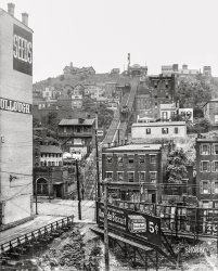
Circa 1915. "Mount Adams incline, Cincinnati, Ohio." One of five "Cincinnati incline" railway elevators serving that city's hillside suburbs. 8x10 inch glass negative. View full size.
Sadly goneAll of Cincinnati's inclines are long gone. The Mount Adams was noteworthy in that it carried streetcars up the incline, and traces of the right-of-way can still be discerned today.  But any hopes of reconstructing it are but a dream, since the area at the foot of the incline is now a tangle of limited-access highways.
A second coming (and going)in HO scale: maybe only 1/87th the size, but definitely a lot more than 1/87th as exciting!


The view todayRookwood Pottery is still visible on the left on the mountain.

So InclinedThe Mount Adams Incline wasn't noteworthy for carrying streetcars, since four of Cincinnati's five inclines did that. The exception was Price Hill, which had a separate passenger-only plane and open platform freight plane.  Mount Adams was noteworthy, however, for being the only incline to carry city trolleybuses and motor buses in its waning years (Price Hill did occasionally carry private motor buses on its freight plane in the 1920s).
https://www.jjakucyk.com/transit/streetcarinfo.html 
Also at the bottom of the photo is a remnant of the Miami and Erie Canal.  Ten locks were required to descend the 3/4 mile distance to the Ohio River now occupied by Eggleston Avenue.  Since canal barges can't navigate the river, and the numerous locks made this a tedious section to traverse, it was abandoned in about 1863. After that time the canal terminated on higher ground near today's county courthouse.
(The Gallery, Cincinnati Photos, DPC, Railroads, Streetcars)

This Smoky Eden: 1905
Circa 1905. "Erie Canal and Mohawk Valley, Utica, N.Y." Panorama of two 8x10 inch glass ... Detroit Publishing Company. View full size. Canal Boat Carl T. Seibel There is a town about 10 miles up canal from this ... 
 
Posted by Dave - 01/03/2018 - 10:13pm -
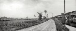
Circa 1905. "Erie Canal and Mohawk Valley, Utica, N.Y." Panorama of two 8x10 inch glass negatives, Detroit Publishing Company. View full size.
Canal Boat Carl T. SeibelThere is a town about 10 miles up canal from this location by the name of Verona, where boats were built as well and its supervisor from 1886 to 1889 was named Carl T. Seibel. Seems a fair guess that he either owned this vessel or that it was named/renamed for him.
Try again2150 NY 5A is a building located in Yorkville, N.Y.
The Skenandoa Cotton Company according to the 1910 city directory was located on Broad Street at the end of Wetmore Street or in approximately the 1200 block of Broad Street.  The building has been modified some and the smokestacks are now gone. The canal would have run right along the north side of the building. The newest Google maps shows a Diva Farms and Casa imports businesses also sharing the building.
112 Years Later
The Skenandoa Cotton Company  Took a bit of searching.  The building still partially stands today as part of the Pepsi warehouse in Utica. After Skenandoa Cotton,  Beaunit Rayon took over the building till the 1960's.   The canal was moved and the old canal along these buildings was filled in. 
CompetitionThis photo nicely captures two competing technologies for transportation -- canals and railroads. I believe the battle had already been won by this time.
Plus ça changeTwenty five years ago I brought my folks' boat down through this area of the canal. Then it ran down the Mohawk with the Thruway to starboard, the train to port. In pouring rain first the trucks on the thruway honked, then the train to port.  I won't record my response.
(Panoramas, The Gallery, DPC, Railroads, Utica)

Buffalo: 1900
... in the caption. - Dave] Buffalo wings Right above Erie Railroad car 44176 looks to be a Free Chicken! What a layout! I ... Buffalo has unearthed the very beginning of the Erie Canal which is somewhere in this photo. It is now part of our waterfront park ... 
 
Posted by Dave - 07/22/2012 - 10:38am -

Circa 1900. "Buffalo, New York. Creek and elevators near foot of Main Street." Detroit Publishing Company glass negative. View full size.
Snow vs. PaperHow did those buildings that look like they're covered in paper survive the brutal winters that Buffalo is famous for?
[Those are the grain elevators mentioned in the caption. - Dave]
Buffalo wingsRight above Erie Railroad car 44176 looks to be a Free Chicken!
What a layout!I swear it's a model railroad masterpiece.
I love this oneI've had this up on my screen for a long time.   I long to walk through this city at this particular time and place.   Chances are little of what we see here remains.
Wow   The only remaining structures that I can ID would be County Hall, the Ellicott Square building and a couple of churches. Check out the Watson Elevator standing to the left. That's a 23 foot deep turning basin now. The detail level is outstanding, thanks man!
-B in B
Buffalo elevatorsIn the next three decades, milling would continue to grow as an industry in Buffalo. In 1930 it would take the title from Minneapolis as the world's largest miller.
Life Long BuffalonianWish you could see all these wonderful buildings today. People come from all over the world to see Buffalo's Architecture. I am presently working just around the corner from the Ellicott Square Building which when completed was the largest office building in the country. The other buildings B in B mentions below are even more spectacular! Buffalo has unearthed the very beginning of the Erie Canal which is somewhere in this photo. It is now part of our waterfront park as a tourist attraction.
William James on Buffalo"We had passed great smoky Buffalo in the raw vernal dawn – with a vision, for me, of curiosity, character, charm, whatever it might be, too needfully sacrificed, opportunity perhaps forever missed…"
		--  The American Scene, p. 477
This photo pretty much sums it up.
Somewhere in there. . .is my grandfather, age 11. Thanks for posting this.
More detail  I also did notice the Old Post Office's (now ECC) tower to the right between the Marine Legs of the paper covered elevator.
  If you look close you can see a DL&W passenger train between the buildings across the crick, pulled into the original passenger station's platforms. That is now the old parking lot for the Naval Park, under the Skyway. 
  The Erie Canal Commercial Slip the previous poster mentioned is located just behind the white freighter docked at the terminal along the river. 
Trains in the streetsI love the trains running right through the streets. As a lifelong Buffalonian, I would love to go back and live in this time for a week -- maybe around the time of the Pan American Expo.
1894 Buffalo AtlasThe map from the 1894 Buffalo Atlas depicting the foreground and buildings directly across the Buffalo River is here.
What is interesting about this is that the two elevators on the map and should be in the foreground (Sturgis Elevator and Eastern Elevator) were demolished by 1900.  The little house is the little yellow rectangle with rear extension at the end of Ganson Street and the brick building all the way at the end is the remnant of the Sturgis Elevator.  I think an alternate caption for this photo should be "Demolition of the Eastern Elevator, Buffalo NY, c. 1900."  You can see the guys with picks and wheelbarrows and the piles of scrap metal being towed to the rivers edge, presumably for loading on a barge.  Temporary tracks have been laid to allow for the movement of the scrap, tracks that do not appear in the 1894 Buffalo Atlas.
The end of Washington Street and Wilkeson and Wells elevators are directly across the river.  The Lyons Elevator is on the left.
The layout of the DL&W complex at the end of Main Street is here.
(The Gallery, Boats & Bridges, Buffalo NY, DPC, Railroads)

Jack-Knife Bridge: 1905
... New York, circa 1905. "Jack-Knife Bridge, City Ship Canal, foot of Michigan Street." Detroit Publishing Company glass negative. ... rather than a large wooden wheel. Also note the Erie Canal style barge tied up at the foot of the Kellogg warehouse. Smoke ... 
 
Posted by Dave - 07/22/2012 - 10:39am -
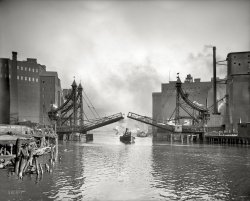
Buffalo, New York, circa 1905. "Jack-Knife Bridge, City Ship Canal, foot of Michigan Street." Detroit Publishing Company glass negative. View full size.
Wonderful mechanical artWhat a great photograph, I just got lost in it. And that bridge! The lifting design is amazing. Look at those rolling counterweights, articulated steam-powered lifting arms, and the beautifully engineered iron-work that contains it all. I love it!
From Google Earth photo: this the bridge at the end of Michigan Street now.
(yawn):  http://www.panoramio.com/photo/12074755
Smoke all overI just wonder what it has been to live in a city that time while smoke was in one's nose all the time. Many of these old city photos seem to reveal an air pollution problem. But I would still be happy to make a visit back to those times!
Toot, toot!What a great photo! You can almost smell the smoke and hear the tugboat's horn!
First built in 1873, apparentlyThere's a lot of interesting history about the Buffalo grain industry here. And I should really get back to work.
And LoSteampunks and boatnerds across the land rejoiced.
IncredibleGreat to see more pictures of Buffalo in its prime. 
AtmosphereI love the way the photo captures the steam/smoke from the tug under the bridge. The steam/smoke is enveloping the left edge of the bridge. Very cool.
Long goneThe bridge in the picture here is no longer in existence.  The bridge shown in the picture from the comment entitled "Wonderful Mechanical Art" is the Michigan Street Bridge that crosses the Buffalo River, not the Buffalo Ship canal.
Lil TootThis must be the tug Disney based his classic cartoon on.
I wish I was the captainOf that steam tugboat. What a beautiful time trip I would make. Thanks again for this fantastic photo.
Kellogg BuildingsSorry Breakfast Clubbers, the Kellogg A and B Buildings didn't store or manufacture Corn Flakes or Rice Krispies. Spencer Kellogg & Sons compounded oils (cooking, vegetable and castor among others) from linseed.
Scuffy the Tugboat.A colorization candidate!  These squat tugs are likely "low-profile" Great Lakes Towing and Salvage boats and were painted dark green on the hull with red deckhouse and white trim, often named for a U. S. state.  Note the trident steam whistle. It must have produced a beautiful a sound.  They were very powerful tugs for their size and some were steered with a whip-staff rather than a large wooden wheel.  Also note the Erie Canal style barge tied up at the foot of the Kellogg warehouse.
Smoke all overIn days past a photo with smoke in the air denoted prosperity and industry going full steam ahead towards the future. The smokier the more prosperous an area was.
Connelly Bros. Ship ChandlersThe business in the lower left, Connelly Bros., was a ship chandlery which served the equipment, etc. needs of Great Lakes freighters coming and going from the port of Buffalo.  It was founded by my great-grandfather John Connelly. He was born in Ireland in 1853 and emigrated to the US.  He and his brothers got started as young men buying and selling (used, I think) rope around the mouth of the Erie Canal and the Buffalo harbor.  I believe that between the chandlery and the bride was the dock of the fire boat. The Connelly Bros. building in the picture was destroyed in the late fifties when a freighter that was tied up for the winter up stream came loose and collided with the bridge.  The bridge tower came down into the business and all was destroyed by the collision and possibly a resulting fire.  I'm not sure if it was the same bridge or a later version.  I think the fire boat in service now(the Edward Cotter?) is still tied up there.  The business was moved to 43 Illinois St. which is right across from the parking structure at the HSBC Arena (now known as First Niagara).  Due to the opening of the Welland canal and the decline of steel and manufacturing in Buffalo, ship traffic became greatly reduced in the 1960s-80s. My father, John Connelly Norwalk, was forced to close the business down in the mid 1980s after operating for over 3 generations within our family.  Almost every member of my dad's family my age and older had a hand in working there at some point.  If you look closely you can see people, possibly my relatives, out in front of the building along the docks.  Thank you for this.  It will make a fantastic family keepsake.
(The Gallery, Boats & Bridges, Buffalo NY, DPC)

Clinton Square: 1905
... to. Also great to see products moved by boat, what canal is that?? [The Erie Canal. -Dave] Detailed Picture! The headboard and chairs appear ... 
 
Posted by Dave - 07/30/2012 - 4:36pm -

Syracuse, New York, circa 1905. "Clinton Square." 8x10 inch dry plate glass negative, Detroit Publishing Company. View full size.
Syracuse Savings BankThe big Victorian Gothic structure at the right is Joseph Lyman Silsbee's Syracuse Savings Bank Building of 1875-1876. Silsbee became proficient in several architectural styles in rapid succession; in 1886 he moved his office to Chicago where he designed many Shingle Style houses and became the first employer of a young man from Wisconsin named Frank Lloyd Wright.
By the names on the shopsWe can see where the Irish migrated to. Also great to see products moved by boat, what canal is that??
[The Erie Canal. -Dave]
Detailed Picture!The headboard and chairs appear to me to be carefully wrapped, perhaps in cotton batting and twine.
The young roustabout near the grocery wagon is looking at the toppled grain sack as if it's a wonder of nature. I wonder if he got motivated enough to clean it up or pulled a "Bart Simpson"?
The gent in the nice threads probably should make that much. He might be the barge captain, owner or both.
Just in front of D. Moran's grocery wagon across the street is that a boy pushing a woman in a wheelchair?
The lawn and flower beds are nicely tended. The garder (street cleaner?) and the young girls all have their attention drawn across the street. Was that horse startled?
Some serious window cleaning on the second floor above O'Herin's. There is a woman in the first floor window. Taking a break or a "desperate houswife" of 1905?
Mailbox, policeman and young boy with a basket on the corner. I wonder what the boy is doing? I know the policeman is on his way from the cigar store to the doughnut shop.
Great bridge design.
Interesting wagon-mounted two man lift.
Great picture but it takes an hour to view!
OverseerThere's a guy with a pipe watching the three guys roll the barrel up the ramp into the boat. I assume he earns as much per hour as all three laborers put together.
AbridgedNow there's something you don't see every day, or ANY day for that matter, a pedestrian lift bridge that is usable in both the lowered and raised positions!  Clever!
Hubbard's Empty CupboardThe empty wagon proclaiming "Chas Hubbard Son & Co, esale, STS" belonged to Charles Hubbard, Wholesale Druggists, 211-213 North Water Street, Syracuse, NY. That address no longer exists, being now part of the James Hanley Federal Building in downtown Syracuse. Mr. Hubbard's rise to pharmaceutical prominence can be read about here.
(The Gallery, DPC, Stores & Markets, Syracuse)

Lafayette Square: 1905
... de LaFayette's visit to Buffalo in 1825, the same year the Erie Canal was completed. This location is just a few blocks north of the Ellicott ... 
 
Posted by Dave - 07/22/2012 - 10:42am -

Buffalo, New York, circa 1905. "Lafayette Square." 8x10 inch dry plate glass negative, Detroit Publishing Company. View full size.
You can't park that here!  Parking next to a fire hydrant is illegal!
The Lafayette Hotelin the center of the shot in currently undergoing a $35M-$40M renovation that will result in one and two bedroom apartments and up to 50 hotel rooms, as well as several businesses on the ground floor.  The exterior and much of the interior are being painstakingly restored to their original appearance.  Target date for completion is May 1.
Three dimensionalThe depth of field and scope of the lens have created one of the coolest looking images yet seen. Great job of scanning to maintain the effect. I feel like I'm looking out a window onto the actual scene.
Your policy has expiredI had no intention of commenting until something struck me as humorous in the building on the right hand side.  I would bet that the New York "Life Insurance" company did not appreciate one of their employees perching himself in an open fourth story window.
Plus 107and the bystanders are less ghostly and considerably less well-dressed.
View Larger Map
Good to seeThat at least two of the major buildings has survived.  What was that glorious masonry gem on the far side of the Square?
[The Buffalo Public Library, dedicated 1887, demolished 1963.]
Shame
What Is It?OK, I have to ask this.  Sure, I have only been on Shorpy about 3 months, but have traveled all over Europe and seen these http://www.urinal.net/pissar/
But I have never seen them in old photos such as here.
Is this a pissoir?  Something for the horse buggies?  Fresh water?  Something for the drivers to "dispose" certain things of?
[Whatever it is, it has an electrical connection to the streetcar grid. - Dave]
*MrK replying*
I see that Dave, thanks!  Missed it the first time.   Also, looking at the shadow, the object looks like it does not have the same dimentions all around.  Looks wide, but not deep according to the shadow.
The photo here on the page is a little too low res to discern where the wire goes or what it is connected to (Dave can you help?).  I see what appears to be a fire call box on the furthest trolley pole in that block corner.
I will ask a few trolley experts here about it and hope to report back :)
Not a lot of automobiles yetbut a year later, on July 4 1906, Buffalo would record its first instance of a pedestrian being fatally mowed down by one of the infernal machines when Henry A Ward, founder of Ward's Natural Science Establishment (and taxidermist of Jumbo the Elephant mount fame) succumbed.
re: The TardisIf it is connected by wire, then so are the horses or the coachman standing close by.
No, I think the wire simply is passing above, to support another segment of the trolley cable running overhead.
[You're looking at the wrong wire. - Dave]
Formerly Courthouse SquareThis location was renamed to commemorate the Marquis de LaFayette's visit to Buffalo in 1825, the same year the Erie Canal was completed.  This location is just a few blocks north of the Ellicott Square Building, designed by Daniel Burnham and opened in 1896 (the world's largest office building at the time).  The Ellicott Square Building was featured on Shorpy a while back:  https://www.shorpy.com/node/10750
Big GunThe large cannon at left center is a Civil War-era Parrott Rifle, named after its designer  Robert Parker Parrott. These were cutting edge when introduced in 1861 and came in variety of sizes. Both the Army and Navy used them up through the early 1890s.
This particular Parrott seems to be a big one, possibly a 200 pounder, meaning it could fire a pointed shell weighing 200 pounds.
Military technology moved swiftly in the late 19th century and Parrotts were phased out  as more modern artillery came into use. Many obsolete Parrotts and other Civil War cannon ended up as martial ornaments in city parks and military cemeteries. 
The scrap drives of World War II took a huge toll on ornamental cannon. Wonder if this Parrott survived?
The Tardis-identity revealedThis is a police call box. Very common at the time. I've attached a picture of a rather more ornate one, but of the same general layout. I think the wire DOES go to the box, for the telephone inside. 
The Tardis-identity revealedVery nice find.  Makes sense now, following that wire to the fire pull box with this police call box makes sense to bundle the wires and be routed back to the same place.
Darn that Chameleon circuit, looks like it will never get fixed!
KleinhansI wonder if Kleinhans wouldn't sell their building, so they built the U-shaped New York Life building around it?
[That's an integral part of the Brisbane Building, constructed 1894-1896. The previous structure, The Arcade, was completely destroyed by fire in 1893.]
Buffalo Tardis: real identity revealedNot a call box, although many had telephone connections in a box OUTSIDE this "booth".  These were used by walking patrolmen as one-man jails.  A rowdy would be stuffed inside, locked up, and the paddy wagon sent for.  They were at various  intersections all over Buffalo, until about 1940.   See photo and caption here.
Hotel LafayetteHere's an update to the previous post about the rehabilitation of the Hotel Lafayette.
I appreciate that their original 1905 sign indicated that the hotel is "Fire Proof". Sleep in safety!
As a side note, the hotel was designed an built by the first accredited female architect in the AIA, Louise Blanchard Bethune.
QuestionsTwo questions.
Where is the smoke coming from?  It looks to be a warm summer day, so it wouldn't be from furnaces in the buildings. It seems to originate on top of the building between the Hotel LaFayette, and Kleinhans.  Or, is it some kind of smudge on the photo plate?
[Buffalo was an industrial center with many factories as well as coal-fired locomotives and steamships. - Dave]
And, did no one ride horses in the city?  Or, did no one ride horses downtown?  I don't see any riders in any downtown photos, and I don't see where you'd tie one up.  All I see s carriages and cars and streetcars.
[City folk didn't ride horses like they were bicycles. They took the streetcar or sidewalk (or biked) to get where they were going. - Dave]
If you go to Buffalo, do check out the renovated Hotel LaFayette.  Its gorgeous!
(The Gallery, Buffalo NY, DPC, Horses, Streetcars)

Rochester: 1904
... with her family as a young child on a packet boat on the Erie Canal. One of my favorite stories to tell when I volunteered at her home as a ... 
 
Posted by Dave - 08/06/2012 - 6:03pm -

"Powers Building, Rochester, N.Y., 1904." Detroit Publishing. View full size.
One for the PreservationistsA nice tour of Western New York the past few days, Dave.
This one's still there:
View Larger Map
Powers CloseupClick to enlarge.

Not Just OneBoth of those large buildings still exist. The left one has had some remodeling to the facade and the roof line has been altered.
StoneworkAbout that construction site: it looks like there is a lot of stonework being done at this phase. I'm going to guess that the picket-like debris is crating for precut stones, possibly Greek style columns that are built up from many smaller stone disks.
5 to 3The men on the bottom left intrigue me for some unknown reason. I wonder what they're doing in the late afternoon amongst all that junk.
[That's a construction site full of building materials. - Dave]
Hustle and BustleThe ghostly elongated motions of people and transportation devices adds further artistic complexity to this fantastic image. You sense the dynamics.
Shorpy Construction Co.Don't think we don't notice how the Shorpy watermark is angled to look like it's painted on the construction site fence!
That Great-Grandpa Shorpy sure knew how to put up a building.
Modernizing It's good to see that this building with its magnificent ornamentation has largely escaped modernization -- but they still managed to muck up the ground floor. I'm trying to figure out where the basement with the hot & cold showers went. 
Some Like it ColdAs always, it is the incredible detail that makes these photos and site come to life. Notice competing insurance companies upstairs from the main entrance of Fidelity Trust: You have Phoenix Mutual Life, and a little higher up, Ashley & Loewenguth. On the ground floor you have a One Price Hatters and Furriers. (Doesn't say it is a low price. Could be a high price. Just says it is one price).
But the best sign in this picture has to be down in the basement. It reads Hot, Cold Shower Baths 25 cents.
I know that many hotel/apartment buildings of the era had a single bathroom down the hall, for all the residents of a floor. But does that really mean that people were excited to go take a cold shower in 1904? Brrrrr.

[And let's not forget "Pony Moore" next door. - Dave]
Super PowersThanks for posting this! The Powers Building is my favorite building in town. So cool to see such an old photo of it in high resolution!
Elevation changeNotice the huge elevation change...there used to be many steps leading up to the front door, now it's at grade.
I guess that's where the underground baths went, further underground!
Grand Union IntersectionThis is the first photo I've ever seen of a "grand union" track junction -- where two two-track railway lines meet, usually at a street intersection, and railroad switches allow any streetcar coming from any direction to turn either left or right onto the intersecting line.
http://www.nationmaster.com/encyclopedia/Grand-union
A girl named SueI'm so very late to the party on this one, but this is the corner of West Main (running left-right) and State/Exchange.  Many of the buildings on State Street (the far right) are still standing today, and I walk by them regularly.
Suffragist Susan B. Anthony was a Rochester resident for most of her life, coming to the area with her family as a young child on a packet boat on the Erie Canal.  One of my favorite stories to tell when I volunteered at her home as a docent was what transpired when she was arrested in 1872 for voting.  The deputy planned to make her pay for her trolley ride to the police station, but she refused, stating that she was traveling at the expense of "this fine gentleman here, and he will pay my fare."  She would have traveled down Main Street that day on these very tracks to the police station.
Thank you for presenting this photo!
How do streetcars turn?Geezer's spotting of the Grand Union Junction gives me incentive to ask something I've long wondered -- when a street car approaches a junction (switch point) how does the operator make the car go in the desired direction? It seems unlikely that he stops and gets out, or that someone is standing by to throw a switch externally. And what ensures that both trucks make the same turn?
Directionality>> how does the operator make the car go in the desired direction
In most cases there is no question of "desired direction." The car follows the tracks, which have already been switched. To change the switch points, the operator would have to stop the car and use a track bar.
(The Gallery, DPC, Rochester, Streetcars)

Buffalo: 1905
... whole way from Buffalo to Chicago by water, through Lakes Erie, Huron, and Michigan, without change of steamer. — The ‘North ... They had to be a little narrow to get through the Welland Canal, which enabled them to bypass Niagara Falls (the direct trip was a little ... 
 
Posted by Dave - 07/20/2012 - 7:17pm -
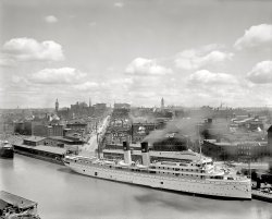
Buffalo, New York, circa 1905. "Looking up Main Street. Steamer North Land at Long Wharf." 8x10 inch glass negative, Detroit Publishing Co. View full size.
Splendid New SteamshipBuffalo Enquirer. January 5, 1895


SAFELY LAUNCHED.
The New Northern Steamship, NORTH LAND,
Launched in Cleveland.
      A Sister Ship to the NORTH WEST and Similar
in Construction and Equipment.
              Cleveland Jan. 5. -- The splendid new steamship NORTH LAND was successfully launched at 2:30 this afternoon at the shipyards of the Globe Iron Works.
         As the launching signal was given by Miss Gertrude Hanna, daughter of President M. H. Hanna, cheers went up from the thousands who had gathered to watch the great vessel slide into the water. The christening ceremony over this magnificent steel vessel, now the finest on the lakes, was performed by Mrs. F. P. Gordon, wife of the Assistant General Manager of the Northern Steamship Company. For the purpose a large platform had been built under the bow of the big vessel, and here the traditional bottle of wine was broken by Mrs. Gordon. The boat was launched sidewise, room being insufficient for a direct plunge.
              The new vessel, which, both the Globe Company and the steamship people say is the finest that ever left these yards, dropped gracefully into the water amid repeated cheers of the crowd. The launching was carried out successfully, and now the Northern Steamship Company has two exclusive steel passenger steamboats, the best constructed and speediest vessels on the lakes.
              The NORTH LAND is quite similar in beauty of design and in elegance of interior construction to the NORTH WEST. The Globe Company had the advantage of the experience gained in the building of the sister vessel, the NORTH WEST, and have made some improvements over what was last year supposed to be pretty nearly perfect in the way of construction. As one of the representatives of the steamship company said, the builder made improvements just as an architect is able to do when he builds a second house. He can learn to perfect his work after the first production. This experience has assisted the company in another way; it has enabled them to have the new steamer ready for launching 30 days earlier than last year.
              This morning the Globe Iron Works were inspected by the officials of the Northern Steamship Company and the representatives of the Buffalo, Cleveland and Detroit newspapers, guests of the steamship company. At these works are built a great many vessels for lake traffic, and the facilities for the purpose are unexcelled. The works are among the largest industries in Cleveland, and employ a large number of men.
              The NORTH LAND, which was launched today, is built of steel throughout, and its hull has been strengthened and subdivided through transverse and longitudinal bulkheads into numerous water-tight compartments. Strength and safety were as much requisites in building the vessel as are speed and comfort. The hull is of novel design, and is constructed around the shafts, giving as little resistance as possible, and also great strength.
              In general the dimensions of the NORTH LAND is 383 feet over all, 360 feet between perpendiculars, the molded breadth is 44 feet, and depth 26 feet.
        The interior arrangements of the boat are as fine as money and excellent taste can make them. Electricity is used in lighting, and one might fancy he was in the parlor of some elegant private residence on terra firma. Mahogany has been largely used in the wood work.
I love the SteamerI admire the photo and I love the "North Land" at first sight. As i read about the steamer a little bit and I know she has an interesting story. The steamer was built in 1895 by (as we all see) the Northern Steamship Company. Mark Tawin wrote about her, whilst travelling on his own tour of America: "All that has been said of this fine ocean ship on the Great Lakes is not exaggerated." "North Land" operated between Chicago and Buffalo, from June through late September. In 1919 she was sold and cut into two pieces at Buffalo and was towed to Montreal, Quebec. Plans to convert and operate her as an ocean liner or troop ship never materialized. She lay in her dock until 1921, when she was dismantled and scrapped. Unfortunately. 
Admirably Appointed


The United States with an Excursion into Mexico,
Handbook for Travellers, by Karl Baedeker. 1904. 


46. From Buffalo to Chicago.
e. By Steamer.

It is possible to go the whole way from Buffalo to Chicago by water, through Lakes Erie, Huron, and Michigan, without change of steamer. — The ‘North Land’ and ‘North West’, the two magnificent steamers of the Northern Steamship Co. (each 386 ft. long, of 5000 tons burden, and accommodating 500 passengers), leave Buffalo (wharf at foot of Main St.) every Wed. and Sat. in summer at 8 p.m. (central time). The — The ‘North Land’ goes through to Chicago, which it reaches on Sat. at 1 p.m.; the ‘North West’ goes to (3 days) Duluth (comp. p. 372), and Chicago passengers must change at (1½ day) Mackinac Island. Through-fare to Chicago $13.50, berths extra (to Mackinac from $3 up). Luggage up to 150 lbs. is free. Fares to Cleveland, $2.00: to Detroit, $4.75; to Mackinac Island, $8.50; to Sault-Ste-Marie, $10.75; to Duluth $17.00. These steamers are admirably appointed in every way and afford most comfortable quarters.

BeautifulAmazing view of Buffalo in its prime. You can see several landmarks that are still standing, including the Ellicott Square Building, and the old post office (now ECC city campus). Looking forward to more photographs of Buffalo!
She's YarHow beautiful she is. It's a shame old ships and old buildings don't live forever.
1895-1921Built in 1895 by Globe Iron Works of Cleveland, Ohio for the Northern Steamship Company. One of two sister-ships. Originally built with three funnels. By 1910 she had new boilers and two funnels as shown in this picture.
In 1905 was running a passenger service between Buffalo and Chicago.
The North Land had been built to undertake the round voyage between Buffalo and Duluth in a week and her owners, the Northern Steamship Company, became the first to introduce seven day cruises.
Scrapped in 1921.
ElegantGrowing up in Western New York State, I passed through Buffalo many times.  I've always loved the graceful lines of those Lake steamers.  They had to be a little narrow to get through the Welland Canal, which enabled them to bypass Niagara Falls (the direct trip was a little precipitous).
Just about all gone now.  Like ghosts.
Sherwin WilliamsI didn't realize the Sherwin Williams logo was that old. I figured maybe 1940's or 1950's.
It's changed in 100 yearsI live in buffalo and looking at this is a bit odd.  Most of what you see there was torn down to make room for RT5 and the I190.
 First, that's not Main Street anymore, it's looking east down Church Street.  The new Main Street would start around were the tall flagpole is, I think. The large white building to the right of the street looks like the Ellicott Square building (completed 1896, the largest office building at the time).  The large tower to the right of that is the old post office, now Erie Community Collage. The problem is it should be closer to the Ellicott Square building.
 The steeple to the left of the street is Asbury Delaware Methodist Church.  Now it's the home of Hallwalls Contemporary Arts Center.  The clock tower left of that is the old town hall.
SpiresSadly, I've never been to Buffalo. There are a number of interesting church spires in this photo. Do any of them still exist?
Map linkThe street centered in this photograph is indeed Main Street.  A map from 1894, depicting the buildings along the left side of the photograph and along Main Street up to Seneca can be found here.
The trapezoid shaped building with the large overhangs is the Delaware, Lackawanna, and Western passenger station.
It is Main streetTo David_T
It looks strange to you because it is in fact Main Street. Then the location of the landmarks make sense. For example, the Ellicott Square building is on Main street.
(The Gallery, Boats & Bridges, Buffalo NY)

Sault Ste. Marie: 1905
Michigan circa 1905. "Sault Sainte Marie Canal celebration. Reviewing stand and Indian village." Dry plate glass ... her stern. Also, parts of the Wolverine have survived in Erie, PA, and the wreck of the Essex does exist in Duluth, MN. See the work of ... 
 
Posted by Dave - 10/27/2019 - 3:23pm -
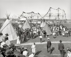
Michigan circa 1905. "Sault Sainte Marie Canal celebration. Reviewing stand and Indian village." Dry plate glass negative, Detroit Publishing Co. View full size.
GunshipsThese two vessels are Navy gunships -- the U.S.S. Michigan and Essex. The Michigan, renamed Wolverine in 1905, was launched in 1844 as a sidewheeler.  The Essex was launched in 1876 as a full rigged propeller steamer. Neither vessel survives.
I'll betMany a pocket was picked that day. Dense crowds with plenty of teepees to duck behind.
The Soo!Yes that is correct English. You can look it up!
Colorful CelebrationThe Semi-Centennial Celebration, held on August 3, 1905, was evidently a very big deal. A commemorative book and history of the St. Mary's Falls Canal was published in Detroit in 1907 by the Semi-Centennial Commission, with this color frontispiece.
Hats!You just never left the house without a topper.
Any Shipshape Shorpsters...know anything about these ships?  It looks like they are powered by steam and sail.
Ahead of their timeNot only are the three young men walking toward us across the field flaunting flouting convention by going hatless, the lad on the left is clearly talking on a cell phone.
First Class TravelThere are some baby carriages to die for on the right.
Wave to the Canadians across the riverThat's Sault Ste. Marie, Ontario, Canada in the background. The clock tower of the Post Office (now the Sault Ste. Marie Museum) at Queen and East Streets is visible above the dory on the ship on the left.
Slice of AmericanaWhat a terrific photograph for studying faces.
The Indian LodgeIt is possible that not every Shorpy reader has had the privilege of camping in a tipi. Since I have done so at Mountain Man rendezvous, I can attest to the superiority of this ingenious abode. The lodges shown in the picture are canvas, which replaced buffalo hide covers once supplies became available in the 1850's. The upper right lodge shows evidence of much use, judging by the well-smoked top. Although it can be a considerable source of amusement to watch several inexperienced men erect a lodge, with experience the poles can be erected, canvas wrapped, and all tied down in no great length of time. Although mountain men of yore spent much of their time sleeping outdoors or under simple shelters, the man with an Indian wife and lodge lived in comparative luxury. Sheltered from wind and rain, gathered around a flickering fire, coffee or food cooking, lounging at ease with possessions hung from the poles at a convenient height, life is good. As they eyes go heavy and sleep is sought in blankets or buffalo robes, the final sight is the night sky as seen through the smokehole with its welter of poles.
As may generally be known, the doorway is traditionally oriented to the east to catch the morning sun, by which we can infer this picture was taken in mid-afternoon, and the two flaps are directed by their poles to point downwind to encourage smoke to leave the lodge, or in the worst weather, to close up the smokehole. The circle of lodges with openings pointed inwards, as seen in movies were a director's artistic pretension. And of course, we now know where the lodgepole pine got its name. 
SteamshipsGreat picture, thanks!  The ships in the foreground look rather older than 1905, but ships on the Great Lakes often live a long time because fresh water doesn't rust them as quickly as seawater.  The one on the left is rigged as a schooner, the one on the right as a barque, but they obviously have main propulsion by steam with the size of the rig reduced because in light winds the iron tops'l would be doing the work.  Note that sails are not bent except for the schooner's mizzen, but smoke is coming from the schooner's funnel. 
Maddeningly, the name of the schooner can be read easily -- but only the first 4 letters, GLOR, the rest obscured by bunting decorations.  Perhaps GLORIANA, or GLORY?  There was a sailing yacht by the former name in this period but she was totally different, it couldn't be the same one.
Note the huge steering wheel on top of the barque's bridge and what is almost certainly a polished brass binnacle next to it.  Among 19th C. sailors it was considered unseamanlike to steer a vessel from an inside station while under sail because the helmsman had to respond promptly to wind changes.  There is a glassed in pilothouse on the level below that was doubtless used more often when under steam.
The schooner is a side wheeler -- you can make out part of the paddle box -- but the barque is evidently equipped with the more "modern" propeller.
On the right background there is a handsome steam yacht that looks like it could have been new or very recent in 1905.
Hats! Hats! Hats!A picture like this makes you wonder how many milliners have fallen by the wayside.
The TepeesThe Tepees were part of a "historical" demonstration purportedly showing the descendants of the Ojibwe Indians who lived on the site before being driven off my the white settlers.
A troupe of Indians were brought in by Louis Oliver Armstrong, a Canadian, who was a minister and self-styled "expert" on Native lore and history. He worked for the Canadian Pacific Railway and was a proponent of opening the west to settlement. He was involved in mapping the west and eventually moved into filmmaking, which started with movies in the early 1900s designed to entice European settlement in the Canadian west.
It was L.O. Armstrong who turned the tale of Hiawatha into a play and spread the mythic appeal of the story. This led to the wide fascination with all things "Red Man."
He assembled several troupes of Indian actors - Ojibwe from the Garden River Reserve (which is near Sault Sainte Marie) and Mohawks from Kanewakhe, near Montreal. They put on tableaus, plays and did reenactments based on real historical events. However, because their traditional costumes often didn't register as "authentic" with the public, they were put into more theatrical costumes (buckskin and feather headdresses of the Plains Indians and used tipis instead of the traditional shelters of the area they were supposed to be representing.
In this case, we see Plains Indian tipis, not the wigwams of the Ojibwe (dome-shaped structures made from saplings, bent wood, covered with bark and skins).
The irony is that a good number of the crowd appear to be native, themselves, and are as well dressed as any other European in the crowd. May of them are the descendants of the Indians the troupe are supposedly depicting.
Not the EssexFrom the comments section above: The vessel in the rear of the photo is not the USS Essex, she is the USS Yantic. We know this for many reasons; what little of the beak head can be seen is the Yantic (vertical slats vs scroll work  on the Essex) and Essex wasn't painted white until after 1910. Also, depending on when this photo was taken, USS Michigan became USS Wolverine on 17 June 1905; so, if this photo was taken after that precise date, she is the Wolverine. She is not Gloria - that is a flag flying in front of the vessel and not her name. Her name would be on her stern. Also, parts of the Wolverine have survived in Erie, PA, and the wreck of the Essex does exist in Duluth, MN. See the work of Maritime Heritage Minnesota for more on Essex; we have digitized all her known logbooks and have been monitoring the wreck's condition yearly. USS Essex is the only known example of the work of shipbuilding Donald McKay known to exist anywhere in the world and the wreck of the Essex is on the National Register of HIstoric Places.
(The Gallery, Boats & Bridges, DPC, Native Americans)

Badger State: 1900
... "leg" was a huge structure on wheels -- on the City Ship Canal, next to the Marine Elevator. View full size. Sis ahoy! I ... old Laker beside her are fascinating, however the little "Erie Canal barge" is amazing. American Colossus This image appears in ... 
 
Posted by Dave - 08/14/2012 - 8:22pm -
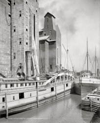
Buffalo, N.Y., circa 1900. "An old-timer at C.T.T. elevator." The Badger State at the Connecting Terminal grain elevator -- whose loading "leg" was a huge structure on wheels -- on the City Ship Canal, next to the Marine Elevator. View full size.
Sis ahoy!I believe her sister ship, the Empire State, was photographed in Duluth circa 1905.
Amber WavesThis photo boggles my mind with all of its incredible detail and sharpness.  It forces me to imagine what it was like to work inside one of the open windows in the grain elevators.  What are the dangers that may lurk inside.  Grain dust explosions or falling from heights hazards?
It begs for color!
Badger State bioBuilt in 1862 as a passenger/freight steamer.
Converted in 1905 to a floating pool hall.
Back to work in 1906 carrying lumber.
Burned and sank in 1909.
Now a popular wreck for divers in the St. Clair River, Michigan.
I've got a mule and her name is Sal...Both the Badger and the old Laker beside her are fascinating, however the little "Erie Canal barge" is amazing.
American ColossusThis image appears in William Brown's book, "American Colossus: the Grain Elevator, 1843 to 1943" (Colossal Books, 2009).
http://american-colossus.blogspot.com
RivetsWhat a nice shot! We can see every rivet on the tube! That ship at the right side seems made of wood.
Wooden steamerThe steamer to the right of the Badger State is the Robert Mills, built in Buffalo in 1888. I cannot identify the canal barge.
Robert Mills historyThat laker sandwiched between the Badger and canal boat was built in 1888 with a 256 by 40-foot wooden hull. Got a new 800 hp boiler in 1893. Sank and abandoned at Manitowoc but raised to become an automobile carrier named "Fellowcraft" in 1918. Abandoned again in 1929.
(The Gallery, Boats & Bridges, Buffalo NY, DPC)

Buffalo Dredging: 1905
... The right side of this picture includes the Black Rock Canal, while the left side is the Niagara River. As a child in the '60s (long ... I believe that the canal was an extension of the old Erie Canal that brought barges down from Lockport and North Tonawanda into the ... 
 
Posted by Dave - 03/10/2021 - 4:02pm -

Circa 1905. "Waterworks and Niagara River, Buffalo, N.Y." Panorama made from three 8x10 inch glass negatives. Detroit Publishing Company. View full size.
Childhood memoryThe right side of this picture includes the Black Rock Canal, while the left side is the Niagara River.  As a child in the '60s (long after this picture was taken) we boys would fish from this breakwall.  The local rowing club would practice in the canal as well.  I believe that the canal was an extension of the old Erie Canal that brought barges down from Lockport and North Tonawanda into the port of Buffalo.  Wow, talk about a bygone era!!  Buffalo was one of the ten largest cities in the US at the time of this picture.  
I'm impressedI can tell from the amount of smoke and the number of smokestacks that you are a modern, prosperous city, Buffalo!
I don't see any buffaloin the dredge scoop yet.
Three legged dredgerThe three legs are driven down into the river bottom. It can raise itself up and level using the three legs. Also helps stabilize its position. I have seen modern versions of this kind of dredger but didn't know the concept has been around so long. Another great Shorpy history lesson.
Also kudos to either Detroit Publishing or Shorpy for the excellent job of stitching these negatives together. 
Spud bargeThe dredge is built on a spud barge. The legs drop by gravity and are not driven into the bottom by any other force. The barge could not jack itself up on them, as is done with some modern drill rigs.
The picture appears to be taken from the Bird Island Pier, looking north along the Black Rock Channel toward the International Railway Bridge (on the left) and the Ferry Street Bridge (on the right, the old one, not the current 1914 iteration) leading to the docks on the Niagara River side of Squaw Island.
Rail traffic over the international Bridge was probably over 200 trains a day at the time this photo was taken, peaking at 264 in 1916. 
(Panoramas, Boats & Bridges, Buffalo NY, DPC)

Harlem River: 1890
... removed when they widened the Harlem River and created The Erie Ship Canal. Today the arch piers that touch the river are now one large arch like ... 
 
Posted by Dave - 07/20/2012 - 1:33pm -
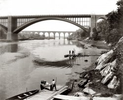
The Washington Bridge and High Bridge over the Harlem River along the northern boundary of Manhattan, looking south. Circa 1890 albumen print from a photograph by William Henry Jackson. Detroit Publishing Co. View full size.
Graffiti on the rocks?Beautiful picture!  I never realized how beautiful the High Bridge had been -- it calls to mind a Roman aqueduct...
Hey, do you think the large rocks in the right foreground have graffiti on them?  I thought first it was some natural geologic pattern, but it sure looks like an "A" on one of them. If so, I wonder what it says ...
High BridgeIt looks like an aqueduct because it was an aqueduct.  The Croton Aqueduct carried water from Westchester county into Manhattan.  Hidden by the Washington Bridge is the still-standing High Bridge tower.  From the tower, water was gravity fed to the rest of Manhattan.
Harlem River BridgesThe Washington bridge (at 181st Street) looks largely the same, but the Harlem High Bridge (at about 174th Street), once famously the prettiest bridge to Manhattan, has been significantly reworked. The entire middle section, over the water, has been replaced with a now-rusting metal structure. It is sadly ugly, but presumably provides easier passage for boats.
There is now a third bridge that sits between the two at about 178th Street.
Here is a view of the two northernmost bridges from the south:

That's the Harlem River Parkway on the left; it follows the route of the old Harlem Speedway, of which I am sure there are many photos in the archives, perhaps to be delivered to us by Shorpy in the future.
Here is an image of the High Bridge showing the replaced section in the middle:

The High Bridge does not carry cars or trains; there is some kind of water pipe embedded under the roadway, and the surface has been closed since the 1960s. Supposedly, local kids used to walk out to the middle and drop rocks on tourist boats passing underneath. Personally, I do not believe this.
The city of New York has allocated money for repairing the surface of the bridge and it is scheduled to reopen as a pedestrian and bicycle route across the East River.
BeautifulNicely architected and nicely implemented! This gives the lie to my boyhood fantasy that nothing significant was accomplished before I was born.
Harlem River SpeedwayLook through the Washington Bridge on the right side and see Highbridge water tower.  It's still there, although the reservoir that was beneath it is now a park.  The muddy shore on the right was later made into the Harlem Speedway for horse & buggy racing.  Today the Speedway is a "Class A" bicycle path on the river side, and the Harlem River Drive inboard of that! The arches that stepped across the river (farthest bridge) were removed when they widened the Harlem River and created The Erie Ship Canal.  Today the arch piers that touch the river are now one large arch like the Washington Bridge in the foreground of this photo. The NYC Parks Department "owns" Highbridge now and they are refitting it for a linear park and bike path. It should be open by 2009.
Historic slide show of the Harlem RiverSee a slideshow of historic images of the majestic Harlem River here.
(The Gallery, Boats & Bridges, DPC, NYC, W.H. Jackson)

Dog Cakes: 1910
... 70 Genesee Street in downtown Utica, within sight of the Erie Canal. In 1937, the building was tripled in size to accommodate the needs ... 
 
Posted by Dave - 08/15/2012 - 3:06pm -

Utica, New York, circa 1910. "United Commercial Travelers of America building." On a block offering a cornucopia of goods and services: Dog Cakes (not to be confused with Twentieth Century Lunch three doors down), dog collars, bananas, cigars, an amusement arcade (the Shooting Gallery), coal, shoes, trunks and, finally, crockery and glassware. 8x10 inch glass negative View full size.
Close to homeThis building is now an apartment complex, but most of the buildings to the right are gone, lost in a massive fire in 1948.  Among them was my father-in-law's store, just out of the picture.   If you could pan to the right, I'd appreciate it!
[Done. - Dave]
OK I'll BiteWhat's a dog cake? 
What better to eat with Dog Cakes butDog Milk!
I took this photo of a can of Dog Milk that I saw in a  Restaurant where I was dining in Japan a few years ago. 
I asked the waitress how many dogs had to be milked to get a whole can of Dog Milk, but she didn't seem to understand.
70 Genesee StreetIn 1905, the company needed more office space and moved to this building, at 70 Genesee Street in downtown Utica, within sight of the Erie Canal.
In 1937, the building was tripled in size to accommodate the needs of more than 200,000 policyholders.
View Larger Map
The lunch is up to dateI'm reassured. If they advertised a 19th Century lunch, it would be ten years past its expiration date. Which is only four years past the Pure Food and Drug Act.
Kid-Free Eatery"20th Century Lunch -- For Ladies and Gentlemen"
Penny ArcadeThat's a great view of an old penny arcade, taken at a time when many of the attractions actually did cost only one cent.  At the doorway is what appears to be a 44-note piano.  These were usually set up to play a tune for a nickel, although the operator could have set it to play continuously as a means to entice passersby to enter.  Along the right wall can be seen a row of Mutoscopes similar to the ones in the photo below.  These played a moving picture supplied by individual frames printed on cards and formed into a reel.  Each real contained one short movie, and since each Mutoscope held only one reel, the arcade would have many Mutoscopes in order to offer a variety of movies.
"Dog Cakes" - No dogs addedSpratts "Dog Cakes" was the first mass-produced dog food. James Spratt came up with "Patented Meat Fibrine Dog Cakes" after seeing dogs eating hardtack biscuits. The biscuits were initially marketed to country gentlemen in England for their hunting dogs.
Production was relatively limited until after James Spratt's death. However, in the 1880s, the company went public and became one of North America's marketed company in the 20th  Century. They were eventually bought out by Purina.
Charles Crufts, who founded the Cruft's Dog Show began as a clerk for Spratt's.
Spratt was secretive about the actual meaty ingredient in his "cakes" and early ads in England intimated it was buffalo.
(The Gallery, Dogs, DPC, Stores & Markets, Utica)

Power and Light: 1904
... me Reminds me of the powerhouse at Lock 7 on the Erie canal when I worked there. Originally the dynamo/generator was run by a water ... 
 
Posted by Dave - 09/15/2012 - 3:28pm -
Circa 1904 somewhere in North America. "Switchboard in dynamo room." (UPDATE: Also seen here.) 8x10 inch glass negative. View full size.
Confidence!The electrical lighting dynamo room has a GAS light fixture - that's confidence for you!
Crossroads of technologyJust above the right side appears to be a gaslight. If it is, what a juxtaposition of technologies. Love the seashell lamp covers.
Polished Slate SwitchboardThe switchboard on the left is constructed with sheets of highly polished black slate held in metal frames, recognizable to me from a similar and much larger switchboard installation in the old San Diego Fire Alarm building. Heavy slate panels were used as non-conducting mounts for high voltage switches, voltage regulators, gauges and other electrical devices.
This photo is very similar to an illustration in the 1902 first edition of "Handbook for the Use of Electricians in the Operation and Care of Electrical Machinery and Apparatus of the U.S. Seacoast Defenses," published by the War Department in 1902, with a second edition in 1904. The book includes descriptions and specs for the construction of power houses for electrical searchlights, which could also have been the function of this setup. Page 56 neatly describes the installation seen here. The entire manual is available online here.
I'm afraid!On the other side of the room by chance, is there a man on an operating table with bolts through his neck?
I'll take a light-power twist, pleaseThis could just as easily be an early soft-serve ice cream machine.
GaslightThat's called "emergency lighting", for when the dynamo stops!
Reminds meReminds me of the powerhouse at Lock 7 on the Erie canal when I worked there. Originally the dynamo/generator was run by a water turbine, but when I was working there in 1998 it had long since been changed to be run by an AC motor. All the Lock motors that ran the gates and valves were still DC so it was a quick and easy way of converting AC to DC. 
 Pretty but dangerousThose old slate switchboards were a work of art but very dangerous. When operating the switches you had to be very careful to touch only the small insulated handle. The slightest contact with the exposed metal parts could be fatal. And even if you were careful you could still get flash burns from an arc as the contacts open. These days switches are required to be enclosed in boxes and even then protective "flash suits" are often worn when operating them.
Knob & TubeWouldjah look at the "Knob & Tube" wiring up on the wall?
(Technology, The Gallery, DPC)

S.S. Utica: 1910
... the Interstate Commerce Commission, citing the 1912 Panama Canal Act, ruled that American railroads could not also engage in marine transportation, and the NYC (as well as Erie, Pennsylvania, and Lehigh Valley) sold their steamship operations on the ... 
 
Posted by Dave - 08/14/2012 - 8:50pm -

Circa 1910. "Freighter S.S. Utica, New York Central and Hudson River Railroad Line." 8x10 inch glass negative, Detroit Publishing Company. View full size.
1904-1949Constructed by the Detroit Ship Building Co., this 325-foot package freighter was launched April 28, 1904, at Wyandotte for the Western Transit Company, the marine operation of the New York Central on the Great Lakes.
In 1915 the Interstate Commerce Commission, citing the 1912 Panama Canal Act, ruled that American railroads could not also engage in marine transportation, and the NYC (as well as Erie, Pennsylvania, and Lehigh Valley) sold their steamship operations on the Great Lakes.  Many of the vessels were consolidated under a new firm, Great Lakes Transit Corporation, for which the Utica ran from 1916 until 1945.  That year, GLTC sold her to Chilean interests who renamed her Quintay.  She was towed down the Chicago River, the Chicago Sanitary and Ship Canal, the Illinois River, and eventually the Mississippi to New Orleans.
The Quintay stranded and became a total loss on Penguin Island in the Messier Channel, Chile, on April 28, 1949, on a voyage from Callao to Punta Arenas while carrying general cargo and drums of oil.
Steamship Utica

Beeson's Marine Directory of the Northwestern Lakes, 1908 

Steamship Utica, built in 1904 for the Western Transit Co. of Buffalo, N.Y.  Gross tonnage: 3533, length: 325 ft., beam: 44 ft.

HmmmmI wonder what the three planks on the side of the hull are.
[Docking fenders. - Dave]
Rounding the Eastern Continent?I was not aware a vessel of this size could move South out of Lake Michigan and down thru to New Orleans in the canal/river system.
[As noted below, the Utica was a Great Lakes freighter. - Dave]
(The Gallery, Boats & Bridges, DPC)

Meet the Loomises: 1939
... days to create farmland. However, once the Erie Canal, and later, the railroads, came in and opened up the fertile (and ... 
 
Posted by Dave - 06/12/2020 - 7:01pm -

        Social Distancing 1.0 -- no matter how close you get, these folks are always at least six feet away.
October 1939. "Graveyard, Shaftsbury Center, Bennington County, Vermont." You can exhume the hi-res Loomises by clicking here. Acetate negative by John Vachon. View full size.
United AboveDivided Below.  (Okay, I'll bite: What's that ball?)
Now, but before the trees in frontFoo. Having once again forgotten how to embed a Street View.
(Edit: Thanks. I've told others in the past how to embed Street View, but, as happens, this time didn't find the trick. A note in the FAQ/Instructions would be handy.
2008:

)
Anyway, trees and jet trails now, but the fence remains.
Vachon had such a good eye.
An acorn?If it is a giant acorn, it is a clumsy image, given its disproportion to the tree. But a tree by itself, or an acorn by itself, might not convey anything, and an acorn proportional to the tree would not be noticed. It brings to my mind the verse from the gospel of John, "Unless a grain of wheat falls into the earth and dies, it remains alone; but if it dies, it bears much fruit." It might be difficult to portray the fall of a grain of wheat in sculpture, but a tree and an acorn seem readily intelligible.  
Not much has changedExcept for more trees.  It's always interesting to see how many more trees exist today than in America of the early 20th century.

AcornThank you for that, Archivist.  But what does the oak signify in this context?  I must confess I’m a bit adrift here.  I get that the chain is united above and divided below (whatever that really means), but does it also refer to the family – united in life, divided in death?  I’m puzzled.
Forests in New England come full circleMuch of New England was clear cut of timber in the pre-Revolutionary days to create farmland. However, once the Erie Canal, and later, the railroads, came in and opened up the fertile (and flatter) lands of the Midwest to farming, most of the agricultural lands were abandoned, and the forests regrew.  It took a couple of hundred-odd years, but now the forests are more verdant than before.
Never mind the acornThe more important part of the carving is the broken chain, symbolizing an ended life. This can also refer to the "divided below," meaning the family circle which is now broken, while "united above" refers to the deceased reunited with God in Heaven.
Clarrisa, ClarissaAnyone else notice that Clarissa's name is misspelled on her headstone?
[Or if her name is Clarrisa, the typo is on her son's headstone. - Dave]
Ah, the Loomis clan.Fairly prolific bunch of New England settler folk. Among their many descendants are such luminaries (Loomis-naries?) as Doodles Weaver and his niece Sigourney.
Got a Loomis in my own family tree, too—the same one on both sides, as a matter of fact. She's the reason my parents were seventh cousins, and the reason an ex and I (who met by chance a quarter of a world away, on another continent entirely) are eleventh cousins on both sides of our families.
New England genealogy, the source of endless amusement.
Interesting IconHere's my take. The tree is a symbol of Jesus and the cross in a lot of Christian communities worldwide. A fruit (or acorn) bearing tree would be a symbol of spiritual rebirth and to family. The chain and the caption of "United above, divided below" represents the passing away of a loved one who will be reunited with family again in heaven. Now tell me I'm wrong.
Illicit Loomis branchOne branch of New England Loomises drifted West to Madison County, New York, and for several generations were known as the “Loomis Gang,” operating out of the Nine-Mile Swamp, not far from Utica.  They alternated horse theft with other larcenies, and were adept at escaping raids by the local sheriff.  Witnesses to their offenses were often stricken with amnesia around the time the cases reached the court docket.  Only the eventual deaths of the key figures brought an end to the Gang’s colorful adventures.
(The Gallery, John Vachon)

Beautiful Utica: 1905
... Elevated Streetcar? The streetcar is rolling over the Erie Canal, which was later filled in at that location, and named Oriskany Blvd. The ... 
 
Posted by Dave - 11/14/2013 - 2:32pm -
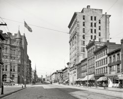
Circa 1905. "Lower Genesee Street -- Utica, New York." Note the streetcar switch tower. 8x10 inch glass negative, Detroit Publishing Co. View full size.
First Time CommenterI've been an avid Shorpy follower for a few years and am just now getting around to signing up for an account. 
This picture, for some reason, spoke to me and I did some digging around on Genesee Street in Utica. Fairly close angle below of current day. The vacant lots across the whole downtown area are pretty sad, especially considering the beauty of the turreted building in the photo. 
View Larger Map
The View TodayThe spire in the background is the steeple on Grace Church.  Built in 1856, it's still there today.
Elevated Streetcar?The streetcar is rolling over the Erie Canal, which was later filled in at that location, and named Oriskany Blvd. The NY State Barge Canal, a short distance north of the Erie's route, replaced it.
Utica Seed CompanyThe sliver of building shown on the far right later housed my father-in-law's business, Utica Seed Co.  In January 1948 a fire started in an adjacent building and the blaze destroyed a large section of the block.  He later rebuilt and a coffee roaster occupies the site, and the area is being redeveloped.
(The Gallery, DPC, Stores & Markets, Streetcars, Utica)

A Foggy Day: 1941
... Transportation Hub The first two versions of the Erie Canal, along with the West Shore railroad, passed directly through Fort Hunter ... 
 
Posted by Dave - 11/05/2013 - 11:06pm -
October 1941. "Freight and passenger station. Fort Hunter, New York." Continuing our jaunt Upstate, courtesy of John Collier. View full size.
Flanger signThe post with the angled blade is a flanger sign, and evidence that we are upstate in serious snow country.
A flanger is a pair of plow blades that are lowered between the rails to clear snow that can build up and cause a derailment. It is either mounted beneath a snowplow or rotary snow blower, or under a separate dedicated car. The flanger must be raised at each switch and grade crossing to prevent severe damage, hence a signpost tall enough to show above a deep snowfall.
Flanger signs came in many forms. Sometimes there were several angled blades, apparently to describe the hazard, sometimes a signboard, either triangular or odd pretzel shaped.
Transportation HubThe first two versions of the Erie Canal, along with the West Shore railroad, passed directly through Fort Hunter and crossed Schoharie Creek with a succession of slackwater dam, stone aqueduct and steel truss bridge. All the railroad tracks are gone, but the roadbed remains as the Canalway bike and hiking path. Several original canal locks and other structures have been restored or preserved and there's a visitor center and historical markers to explain it all; see this.
The third and final version of the Erie Canal adapted the adjacent Mohawk River to its purposes. The modern Lock 12 and its associated river control dam are located at Fort Hunter.
Flanger notes.Most railroads used converted cabooses for their flanger cars. However, some companies utilized cars that looked not unlike a flatcar with two (for bi directional running) angled blades under the car.  It took quite a man to operate the latter open air types in the dead of winter.
Up in these parts, we called them a freight "house"I see the agent is in evidenced by presence of his car.
He must get lonely working by himself.
Let's pay him a visit!
(The Gallery, John Collier, Railroads)

Bedded Wheat: 1906
... to get to the Eastern Seaboard communities it had to go by Erie Canal barge. It made sense to mill it in Buffalo so it could be packed more ... 
 
Posted by Dave - 08/20/2012 - 11:06am -
Niagara Falls, New York, circa 1906. "Natural Food Conservatory. The whole wheat cleaned and ready for use." Incipient Shredded Wheat. 8x10 inch dry plate glass negative, Detroit Publishing Company. View full size.
MeowKitty's dream come true!
Shredded FarkFarked again!
The Wheat Stops HereAs I recall from my school days in suburban Buffalo, it was milling that made Buffalo a "big" city.  Grain could easily be transported on large ships from the upper Midwest to the Buffalo/Niagara area on large freighters, but to get to the Eastern Seaboard communities it had to go by Erie Canal barge. It made sense to mill it in Buffalo so it could be packed more efficiently on the barges.
Eventually railroads replaced the canal and the milling centers moved farther west.
(The Gallery, DPC, Factories, Farked)

Flour Power: 1911
The Buffalo River, city ship canal and flour mill elevators circa 1911. "A busy section of the canal -- Buffalo, N.Y." 8x10 inch glass negative. View full size. ... launched 2 July 1892 also by Globe, ran for the Erie & Western Transportation Company, a subsidiary of the Pennsylvania ... 
 
Posted by Dave - 08/06/2014 - 10:50am -
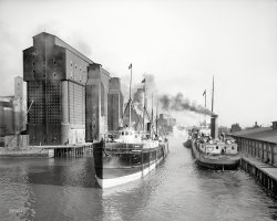
The Buffalo River, city ship canal and flour mill elevators circa 1911. "A busy section of the canal -- Buffalo, N.Y." 8x10 inch glass negative. View full size.
Freighters' FateToward the end of the 19th century and into the 20th a handful of Eastern railroads established steamboat lines as extensions of their services that carried freight westward and mostly grain eastward.
The Bethlehem, launched 29 February 1888 as the E. P. Wilbur by the Globe Iron Works at Cleveland, ran for the Lehigh Valley Transit Company, a subsidiary of that railroad.
The Schuylkill, launched 2 July 1892 also by Globe, ran for the Erie & Western Transportation Company, a subsidiary of the Pennsylvania Railroad, to connect with the Northern Pacific at Duluth.
The railroads were forced to divest these steamship lines by the Panama Canal Act of 1912. Aside from their builder and similar service, both vessels shared a common experience of lake package freighters upon the advent of the United States' entry into the Great War: Requisition or outright sale for wartime service on saltwater. The Bethlehem was cut in half at Ashtabula in 1917 and reassembled at Montreal and slightly enlarged.  It survived the war and entered British registry in 1921, and was dismantled two years later.
The Schuylkill was halved at Buffalo and reassembled at Quebec. On its first voyage on saltwater the Schuylkill was torpedoed by German submarine U-39 on its delivery voyage to Greece, 21 November 1917, becoming one of the 157 vessels sunk by the U-39 during the war, second largest total among Germany's U-boat fleet.
The Blue PeterThe flag on the foremast of the ship on the left is the flag for the letter "P". When it was raised in port it indicated that the ship would be sailing soon and all passengers and crew should make haste to get on board. The flag was called the Blue Peter as it had a white square in the center of a blue flag.
(The Gallery, Boats & Bridges, Buffalo NY, DPC)

River City: 1900
... is imported via the Peace Bridge between Buffalo and Fort Erie, Ontario, I believe. The import arm of the brewery is located in Buffalo. ... boards, and water bikes so one can paddle in the Erie Canal and Buffalo River to investigate the silos, and returning wildlife. A ... 
 
Posted by Dave - 09/22/2017 - 8:39am -
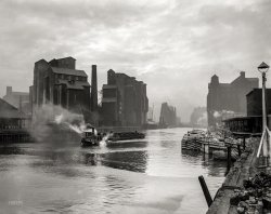
Buffalo, New York, circa 1900. "Buffalo River and elevators, foot of Main Street." 8x10 inch dry plate glass negative, Detroit Publishing Company. View full size.
A Great PhotographI have spent more time studying this anonymous photo than any I have seen on Shorpy--and I've seen them all. It is an amazing composition. The range of tones and textures, the surface of the river, smoke, steam and clouds, the weathered dock and coal in the foreground. Those elevators look like sets for a Fritz Lang film. And the overall oppressiveness. A great photograph.
Flour millingMinneapolis was the flour milling capitol back at that date, but Buffalo was its big rival. Eventually, by about 1930, Buffalo became the biggest flour producer, largely due to shipping costs and a special political deal to allow Canadian wheat to be milled "in bond" in the US and passed on to European markets, which gave Buffalo a clear cost advantage.
Reimagined grain silosToday, a few of the old grain silos have been painted as Labatt's beer cans.  Labatt's, a popular Canadian pilsener, is imported via the Peace Bridge between Buffalo and Fort Erie, Ontario, I believe.  The import arm of the brewery is located in Buffalo. The repainted silos are a tribute to what is arguably western NY's most popular beer.
You just have to see it to believe it!
Also, you can tour the silos now, and even go up inside one.  This is not for those afraid of heights (like me), something the tour operator stresses.  One silo is used on occasion for recording music.  There are also companies in the area that rent out kayaks, canoes, water boards, and water bikes so one can paddle in the Erie Canal and Buffalo River to investigate the silos, and returning wildlife.
A great job has been done on the Buffalo waterfront, there is ice skating in the winter, there are new restaurants, breweries, and many wildlife habitats recreated from what was once a polluted wasteland.  The City of Buffalo has a lot to be proud of for once.
(The Gallery, Boats & Bridges, Buffalo NY, DPC)

City of Ottawa: 1907
... Rail Road. Sold in 1906 to the Montreal & Lake Erie Steamship Company, reflagged Canadian, repowered, and renamed the City of ... was brought down the Chicago River, Sanitary and Ship Canal, and the Illinois and Mississippi Rivers for a conversion that never ... 
 
Posted by Dave - 01/22/2018 - 11:21pm -

Cleveland circa 1907. "Steamer City of Ottawa entering Cuyahoga Creek." 8x10 inch dry plate glass negative, Detroit Publishing Company. View full size.
What is supporting that bridge?Was this photo somehow manipulated or am I just not seeing the bridge/ferry landing properly? The shadows do not look correct, nor does the water beneath it. Is the dark pile which is barely visible made of steel, and all that is bearing the weight?
[It's a swing bridge in the open position. -tterrace]
Thanks Dave...makes perfect sense now! I hadn't considered that it was pointing 90 degrees from its normal orientation :-) (even though I have a defunct center pivot one close by)
The Name GameCity of Ottawa had a pretty long life on the lakes, a nearly went further. Christened the INDIA in 1871, she joined sister ships in service known as CHINA and the JAPAN. From the annals of the Toronto Maritime Society, these were no run of the mill steamers plying the Great Lakes.
"...The passenger cabin of each was a veritable palace compared to other ships then operating. The staterooms opened off a long open passageway in which the dining tables were set at mealtimes. At the forward end of the cabin was the men's smoking room, while at the after end of the passenger area the cabin opened out into a spacious and luxuriously appointed ladies' cabin, complete with grand piano. The woodwork up to the level of the clerestory was varnished, while the deckhead was painted white. Woodcarvings were in evidence everywhere. The entire cabin was fitted with carpeting and an elegant companionway led down to the main deck where the purser's office was located. As usual for the period, bathroom facilities were not provided in the staterooms but each room did boast "running water" in that reservoirs mounted over the sinks were filled daily by the stewardesses and after that gravity did the rest. The galley was located on the main deck and the food (of excellent repute) was brought to the cabin by means of a primitive lift."
Ironically, while she went by City of Ottawa renaming for most of her sailing days, the ship started as INDIA and ended that way as well, while being refitted for saltwater use during WWII. She was sent down the Mississippi River to New Orleans but deemed too old and unfit, was eventually laid up along Lake Ponchartrain, where it's believed she meet her end to scrappers in 1945.
Launched on June 20, 1871 at Buffalofor the Atlantic, Duluth & Pacific Company by Gibson & Craig and the King Iron Works, the India was the first of a trio of state-of-the-art iron passenger and freight vessels running between Buffalo and Duluth, the others the China and Japan.  Beginning the next year and for the next decade it ran for the Lake Superior Transit Company, allied with a pool of railroad-related steamship companies and after that with the Anchor Line, part of the Pennsylvania Rail Road.  Sold in 1906 to the Montreal & Lake Erie Steamship Company, reflagged Canadian, repowered, and renamed the City of Ottawa, the vessel operated as the firm's name implies.  Its passenger accommodations were removed in 1913 when Canada Steamship Lines Ltd. acquired the vessel and placed it in the package freight trade between Hamilton and Montreal.  Laid up in 1926, the City of Ottawa was sold back into American registry briefly in 1928 and renamed India, and the next year back into Canadian registry for the Algoma Central Railway Company and renamed Sault Ste. Marie, running between Fort William and Toronto.  In 1930 it again entered American registry and reverted again to the name India, cut down to a coal barge.  Requisitioned by the Maritime Commission for war service in 1942, the India was brought down the Chicago River, Sanitary and Ship Canal, and the Illinois and Mississippi Rivers for a conversion that never occurred.  The India was dismantled on the shore of Lake Pontchartrain in 1945.
The William L. Scott was built at Buffalo in 1890 by the Union Dry Dock Company for that city's Hand & Johnson Tug Line.  It was abandoned and dismantled in 1915, probably at Erie, Pennsylvania. 
Swing bridge?Never was a real fan of bridges that move. Really like them sitting still and anchored.
Getting A LiftFor fans and non-fans of moving bridges, the current edition at or near that same spot is a rather impressive rail lift bridge, rather than swing version. Everything's up to date in Cleveland.
Tugging at your heartThe tug WILLIAM L. SCOTT, built in 1890, was steam powered and of wood construction, weighing 54 gross tons, with dimensions of 67.9 x 17.4 x 10 feet.  It was dismantled in 1915 at Union Dry Dock, Buffalo Shipbuilding.
I suspect the boat may have been named for Pennsylvania congressman William Lawrence Scott (1828-1891).  
(The Gallery, Boats & Bridges, DPC)

High Bridge: 1905
... started out as an axeman(clearing trees and brush) on the Erie Canal, and advanced to one of the lead engineers. The water supply system of ... 
 
Posted by Dave - 06/05/2015 - 11:45am -
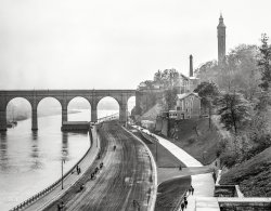
New York circa 1905. "High Bridge and the Speedway looking south." The 1840s aqueduct over the Harlem River, closed since 1970, is reopening next week after a $60 million restoration. 8x10 inch glass negative. View full size.
Sic TransitIt's generally a long, uncertain road in the United States from the merely out-of-date to the venerable, and in 1927 the High Bridge barely escaped demolition, losing its magnificent river-spanning center arches to a single, uninspiring steel span, to allow larger ships to pass beneath.
John B.John B. Jervis, who engineered the Croton Aqueduct (and thus the High Bridge) was a remarkable guy. A largely self-taught engineer, he started out as an axeman(clearing trees and brush) on the Erie Canal, and advanced to one of the lead engineers. The water supply system of NYC had become a morass of political inaction and infighting when he took over the Croton construction, and he was in large part personally responsible for its successful completion. Port Jervis, NY is named for him. His autobiography is an inspiring read.
Major landmarks remain
(The Gallery, Boats & Bridges, DPC, NYC)

Midland King: 1910
... that would bring the grain to Montreal for export, or to Erie Canal barges or eastern railroad connections. On its return trips it carried ... 
 
Posted by Dave - 10/14/2018 - 3:45pm -
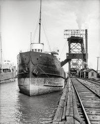
Circa 1910. "Freighter Midland King, Cleveland, Ohio." 8x10 inch dry plate glass negative, Detroit Publishing Company. View full size.
The Midland Kingwas the second "upper laker" built for the Canadian Great Lakes grain trade, too large to navigate the old Welland and St. Lawrence canals.  Launched 19 August 1903 by the Collingwood Shipbuilding Company, Ltd., at Collingwood, Ontario, for the Midland Navigation Company, Ltd., it delivered grain from the Canadian lakehead, the twin ports of Fort William and Port Arthur, to Port Colborne, Ontario, or Buffalo, for transshipment to smaller vessels that would bring the grain to Montreal for export, or to Erie Canal barges or eastern railroad connections.  On its return trips it carried coal, especially to fuel the Canadian Pacific and, after 1918, Canadian National, the railroads that brought the grain to the lakehead.  It is receiving such a cargo in this photograph.  The vessel was scrapped at Hamilton, Ontario, in 1937.
(The Gallery, Boats & Bridges, Cleveland, DPC, Railroads)
Syndicate content  Shorpy.com is a vintage photography site featuring thousands of high-definition images. The site is named after Shorpy Higginbotham, a teenage coal miner who lived 100 years ago. Contact us | Privacy policy | Accessibility Statement | Site © 2024 Shorpy Inc.